
SFS5a
Location: Brewster
Australian Soil Classification: Vertic (& Ferric), Mottled-Hypernatric, Grey SODOSOL (with very thick subsurface horizon)
General Landscape Description: Undulating plain.
Site Description: Simple slope with gilgai microrelief - depression component.
Land Use: Raised bed cropping.
Geology: Quaternary - Newer Volcanics
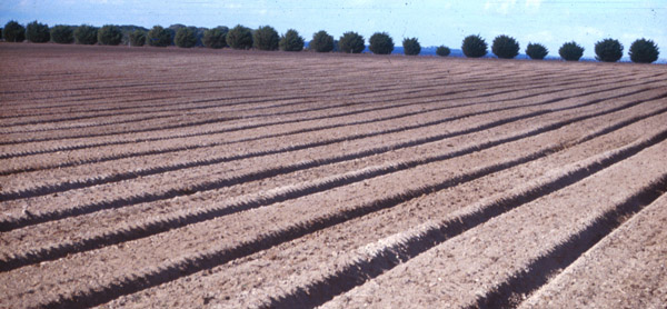 SFS5a Landscape. Note: slight undulation in bed lines due to gilgai, as well as pockets of A2 material bought to surface with cultivation. |
Soil Profile Morphology:
| Surface Soil | 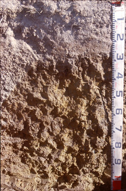 SFS5a Profile | |||
| Ap | 0 - 20 cm | Brown (10YR4/3); fine sandy loam; weak to very firm consistence dry; pH 5.5; clear change to: NOTE: highly variable and mixed material from cultivation, Ap originally likely to be less than 10 cm in depth and is now dominated by apedal A2 material. | ||
| A2 | 20 – 20/90 cm | Light brownish grey (10YR6/2) conspicuously bleached (10YR8/2 dry); fine sandy loam or gravelly loam; pockets of medium to very coarse (5-30 mm) buckshot gravel where <10% is magnetic; pH 6.1; clear, irregular and wavy change to: NOTE: buckshot comprises up to 80% of this horizon in places and can form a layer 100-400 mm thick, at some sites this is cemented into a pisolitic mass. | ||
| Subsoil | ||||
| B21gt | 20/90+ cm | Dark grey (10YR4/1) (50%) with yellowish brown (10YR5/6) and fine dark red (2.5YR4/8) mottles becoming weak red (2.5YR5/4) at depth; medium clay; fine (<5 mm) polyhedral structure; smooth fabric; pH 7.0. | ||
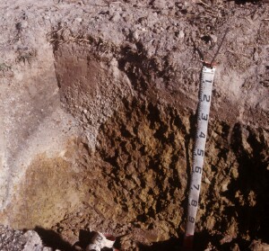 SFS5a profile showing extremely variable horizon thickness associated with gilgai. | ||||
Key Profile Features:
- Soil profile variability due to gilgai microrelief.
- Strong texture contrast between surface (A) horizons and subsoil (B21) horizon.
- Conspicuously bleached surface (A2) horizon and ‘buckshot’ gravel.
Soil Profile Characteristics:
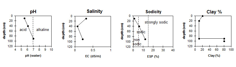
pH | Salinity Rating | |||
Surface (A1 horizon) | Strongly Acid | Medium | Non-Sodic | None |
Subsoil (B21 horizon) | Neutral | Low | Sodic | Strong |
Horizon | Horizon Depth (cm) | pH (water) | pH (CaCl2) | EC dS/m | NaCl % | Organic Carbon % | Nitrogen % | Exchangeable Cations | |||
Ca | Mg | K | Na | ||||||||
meq/100g | |||||||||||
Ap | 0-20 | 5.5 | 5.1 | 0.31 | 0.02 | 2.9 | 0.27 | 4.1 | 0.8 | 0.6 | <0.1 |
A2 | 30-50 | 6.1 | 5.4 | 0.07 | 0.86 | 0.57 | 0.15 | 0.19 | |||
B21gt | 80-100 | 7 | 6 | 0.21 | 5.8 | 12 | 0.66 | 3.9 | |||
Horizon | Horizon Depth (cm) | Exchangeable Aluminium mg/kg | Exchangeable Acidity meq/100g | Field Capacity pF2.5 | Wilting Point pF4.2 | Coarse Sand (0.2-2.0 mm) | Fine Sand (0.02-0.2 mm) | Silt (0.002-0.02 mm) | Clay (<0.002 mm) |
Ap | 0-20 | <10 | 11 | 33 | 9.1 | 4.1 | 37.7 | 27.5 | 20 |
A2 | 30-50 | <10 | 1.4 | 22 | 3.1 | 2.2 | 48.8 | 37.5 | 10.5 |
B21gt | 80-100 | 11 | 53.6 | 30.8 | 1 | 8 | 5.5 | 80.5 |
Management Considerations:
Whole Profile
- Plant available water capacity (PAWC) is considered to be low (estimated at 81 mm) in the upper 100 cm of this soil profile.
- Described by the owner as ‘crabhole country’, this slightly elevated, gently sloping land has well developed ‘gilgai’ features in the subsoil. The very variable nature of this soil is evident in material in the beds which have white A2 horizon material, buckshot, pisolitic cemented buckshot and subsoil clay all present at the ground surface. ‘Spew’ or ‘hollow units’ are elongated downslope (~10 m). ‘Puffs’ are of smaller lateral dimensions than the ‘hollows’ being 1–3 metres across. In the excavated pit, two faces were picked back. SFS5a to show deep A2 with buckshot and SFS5b to show puff unit (shallow depth to clay).
- This soil presents real problems to the agriculturalist. Water holding properties are extremely different in the ‘puff’ compared with the hollow and this is often evident in the crop. The topsoil is not well structured, disintegrates to a ‘flour’ when dry-tilled, is weak and ‘spewy’ when wet and hard set when dry. Protection of the surface with ground cover is essential to reduce the slaking and sealing effects of rain. Under high rainfall / runoff conditions this soil is potentially highly erodible. The subsoil is sodic and has a high clay content so this soil is also prone to severe waterlogging. The slope of the land and the forming of beds should alleviate this in the surface horizons but erosion is a potential hazard should the furrows carry excessive runoff.
- Paddock in pasture since 1948. Turnips in 1997. Raised beds for wheat in 1998 (5 t/ha). crabhole country, slightly elevated, gently sloping. Very variable soil visible in material in beds. White spew horizon material, buckshot, pisoltic cemented buckshot and subsoil clay all present at bed surface. Spew/hollow units are elongated downslope, ~10 m. Puffs infrequent 1-3 m. Pit excavated 100 m upslope from gate into raised bed paddock and 4 m inside fence. 2 faces picked back. SFS5a to show deep A2 with buckshotsand SFS5b to show puff unit (shallow depth to clay).
© State of Victoria (Agriculture Victoria) 1996 - .

This work, Victorian Resources Online, is licensed under a Creative Commons Attribution 4.0 licence. You are free to re-use the work under that licence, on the condition that you credit the State of Victoria (Agriculture Victoria) as author, indicate if changes were made and comply with the other licence terms.
The licence does not apply to ‘branding’ or some ‘images or photographs’ that may be owned by third parties. We ask you to seek prior approval to use images using the VRO feedback form. Access to higher quality images can also be provided on request.
This page was last updated on .