
Coastal Acid Sulfate Soils
Coastal acid sulfate soils (CASS) occur naturally along many parts of Victoria's coastal zone and, if left undisturbed, are largely benign. However, if disturbed, i.e. water drains from the soil and air enters, they can react with oxygen and produce sulfuric acid. This can be detrimental to the environment with impacts that include acidification of water and soil, de-oxygenation of water, poor water quality, dissolution of soil, rock and concrete, and corrosion of metals. Sometimes impacts can be extreme, e.g resulting in fish kills.
The following animation provides a simple illustration of how acid sulfate soils are formed and how they may be exposed to oxygen through various means of soil disturbance.
This page deals specifically with acid sulfate soils in coastal environments that are connected to the sea or have been in the recent past (from 10,000 years ago to the present, i.e. the Holocene epoch).
Victoria may also have coastal acid sulfate soils that have been preserved from earlier times, especially the last inter-glacial warming of the Pleistocene Epoch (130,000 to 114,000 years ago). If these exist, predicting where they are is problematic.
This page does not deal with Coastal Acid Sulfate Soils in the inter-tidal zone, i.e. land between the high and low tides.
There are also acid sulfate soils in inland environments such as peats, inland water bodies and inland water-ways that are not and have not been connected to the sea. These are called Inland Acid Sulfate Soils and they are not dealt with here.
This page is intended to help manage high risk activities on land that has the potential to contain Coastal Acid Sulfate Soil. The Victorian Coastal Acid Sulfate Soils Strategy should also be consulted.
What are Acid Sulfate Soils?
Acid sulfate soils have one or more layers of soil that
- contain metal sulfides, or
- contain metal sulfides and, because of partial oxidation of the metal sulfides, also contain sulfate, and are acidic.
- are acidic and contain sulfate due to the complete oxidation of the metal sulfides to sulfuric acid.
How do Coastal Acid Sulfate Soils form?
Acid Sulfate Soils can form in coastal environments where microbial decomposition of organic matter in water logged soils and sediments which are rich in metal cations and sulfate, creates the reducing conditions which produce metal sulfides. The metal sulfide is usually pyrite (FeS2).
In many coastal environments, the sea is effectively an endless supply of sulfate. Accumulation of large quantities of pyrite is only limited by the supply of iron rich sediments, organic matter and the maintenance of anoxic conditions, i.e. the soil must remain waterlogged or sediment remain submerged, for pyrite to be preserved. Examples of environments where coastal acid sulfate soils are found include estuaries, morasses, lochs, marshes, swamps, lagoons, lakes, abandoned meanders, and the land surrounding these features.
Where are Coastal Acid Sulfate Soils in Victoria?
New research was conducted by the former DPI and DSE, to improve our knowledge of where Coastal Acid Sulfate Soils occur along Victoria’s coast. Land was mapped that has the potential to contain Coastal Acid Sulfate Soils, i.e. Prospective Land, rather than mapping the individual bodies of Coastal Acid Sulfate themselves since they are often hidden below more recent soils.
This is new mapping was based on:
- analysis of coastal geomorphology,
- understanding how Coastal Acid Sulfate Soils form,
- understanding that sea levels have varied and that during the mid-Holocene, the sea was 1.5 m higher than it is today,
- and soil sampling.
|
This low quality video clip runs for 40 seconds and is 2.6MB in size, which will take some time to automatically download if you are using a slow internet connection. We also provide a high quality version of the clip, and to view this you need to click on the 'HD' button that appears in the navigation controls for the player. This high quality version of the clip is 4.0MB. |
Consequently, conditions conducive to the formation of Coastal Acid Sulfate Soils, would have occurred at elevations higher than would be expected at current sea levels. Where conditions are suitable for their preservation, these relict soils can be found in areas above those currently affected by today’s tides. In some of these more elevated Coastal Acid Sulfate Soils, the soil layers containing metals sulfides have been found under more recent sediments and soils. For example, under alluvial sediments, sand sheets, dunes, beach ridges, levees, or peat. Therefore, land at elevations above the 2 m AHD contour has also been mapped as Prospective Land.
Coastal Acid Sulfate Soils have also been found below the waters edge, i.e. in soils formed from sediments that are usually or intermittently flooded or water-logged, e.g. swamps, morasses and marshes. Note that sediments under permanent water bodies, e.g. lakes, and waterways in coastal environments should
be assumed to have metal sulfides.
Some parts of Victoria’s coast have been modified so that the original geomorphic features are no longer present. The potential of this modified land must be assessed from information that pre-dates the modification such as geology maps or soil maps. Modified landscapes that have the potential to contain Coastal Acid Sulfate Soil have been mapped as Made Land.
Current results of the new research are studied using the links immediately below. These maps are subject to change without notice, as new information becomes available (Maps 1, 2 and 3 have been updated in May, 2010). Mapping has identified that most of the Prospective Land is located in the coastal lowlands. A list of locations is available.
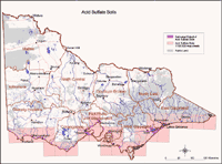
The new maps update the previously available coastal acid sulfate soil hazard maps produced by Paul Rampant and co-workers (Rampant et al., 2003). However, their report and their maps are provided below as an historical reference.
Prospective Land: land that has the potential to contain Acid Sulfate Soils
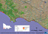 Far South West Coast (from Peterborough) | 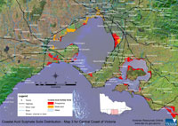 Central Coast (from Torquary to San Remo) | |
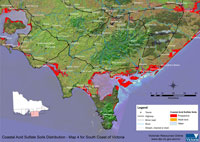 South Coast (from San Remo to Seaspray) | 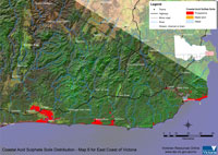 East Coast (from Marlo to Mallacoota) |
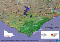
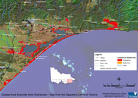
The report on a pilot study of Victorian coastal acid sulfate soils produced by Rampant et al., (2003), is available for download below. The maps from this report are available by clicking the map to the right. |
 | Coastal Acid Sulfate Soils Report (PDF - 939 KB) Coastal Acid Sulfate Soils Report (DOC - 5.8 MB) To view the information PDF requires the use of a PDF reader. This can be installed for free from the Adobe website (external link). | 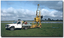 Gemco sampling rig in operation. This was used to mechanically extract samples to a depth of 5 metres. |
A spatial dataset of Coastal Acid Sulphate Soils (DOI 10.4226/92/58e723a645d1f) is freely available through the DataVic website.
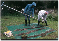 | Hand Augering for acid sulfate soils close to Melbourne. Note the grey and black layering typical in the soils from this environment . Often there may be layers of shell (sometimes up to 70%) within the profile. Hand augering to 4-5 m was quite common during this study. |
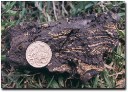 | The straw-coloured material in this black clay is the mineral Jarosite. Jarosite is evidence that there is oxidised acid sulfate soils. It is found in places where the ASS has been disturbed (excavated or drained) so that the previously inundated ASS layers have been exposed to air. This shows the typical Jarosite formation in drained soil: first appearing along the root channels. This sample was taken from South Melbourne. |
Related Links
- The new strategy on Coastal Acid Sulfate Soils in Victoria, can be found on the DELWP website. The strategy explains why CASS is a management issue in Victoria. The strategy helps land owners, and land and water managers to avoid disturbing CASS.
- Acid Sulfate Soil and Rock. Downloadable document on the EPA Victoria website.
- Information about Acid Sulfate Soils on the Queensland Department of Environment and Science
- Information about Acid Sulfate Soils in NSW - on the NSW Department of Primary Industries website. Includes information on distribution of ASS; causes of acid sulfate soil oxidation; effects of acid sulfate soils; management and remediation of ASS in NSW; online technical papers.
- The Government of Western Australia provides several sources of information on acid sulfate soils specific to WA. The Department of Environment and Conservation provides information, links and downloadable documents on managing acid sulfate soils as well as links to spatial information on the extent of acid sulfate soils in WA.
- Western Australian Planning Commission website provides downloadable Planning Bulletins - to provide advice and guidance on matters that should be taken into account in the rezoning, subdivision and development of land in WA that contains acid sulfate soil.
- Information about National Coastal Acid Sulfate Soils on the Department of the Environment, Water, Heritage and the Arts.
© State of Victoria (Agriculture Victoria) 1996 - .

This work, Victorian Resources Online, is licensed under a Creative Commons Attribution 4.0 licence. You are free to re-use the work under that licence, on the condition that you credit the State of Victoria (Agriculture Victoria) as author, indicate if changes were made and comply with the other licence terms.
The licence does not apply to ‘branding’ or some ‘images or photographs’ that may be owned by third parties. We ask you to seek prior approval to use images using the VRO feedback form. Access to higher quality images can also be provided on request.
This page was last updated on .