
Distribution of Gully Erosion in Victoria
Gully Erosion Home | Gully Initiation & Development | Gully Reclamation Techniques | Conclusions | References
A brief discussion concerning the susceptibility of southeastern uplands of Australia to water erosion and the spatial pattern of gullying in relation to tunnel erosion is made in the entry on the latter topic. Leeper (1955) mentioned that sheet and gully erosion were evident in much of the northern foothills of the State. The map of soil erosion in Victoria produced in 1944 (State Regional Boundaries Committee, 1944) contained notation of `shallow', `occasional deep' and `numerous deep' gullies (see Land degradation in Victoria).
The notes which accompanied this map included reported gully erosion in the Barwon, Central Highlands, Corangamite, East Gippsland, Glenelg, Loddon, Port Phillip, Upper Goulburn, Upper Murray and Wimmera regions. Other published reports of gullying included the Avoca River (Rutherfurd and Smith, 1992), Cairn Curran Reservoir (Forbes, 1950), Campaspe River (Lorimer and Schoknecht, 1987), Eppalock (Department of Conservation, Forests and Lands, 1985; Davis et al.,1999), Melton Reservoir (Forbes, 1948) and Tullaroop Reservior (Forbes and Gloe, 1949) catchments and, specifically, land near Alexandra, Ararat, Beaufort, Colbinabbin, Crowlands, Darraweit Guim, Glenthompson, Inglewood and Landsborough (Milton, 1971).
The spatial link between tunnel and gully erosion at a state-wide scale is presented in the entry on tunnel erosion and estimates of rates of these types of (undifferentiated) land degradation for various basins covering the period 1985-1991 were published in the 1991 State of the Environment Report (Commission for the Environment, 1992).
| The following information relating to the map of gully density was provided by Ian Sargeant. The distribution of gully erosion in Victoria was derived from the unpublished research of Lindsay Milton in the 1970s and reassessed by Sargeant in the 1980s. Four categories of land were delineated on the basis of gully length (km) per unit area (km2). The gullies were identified on 1:16 000 or 1:80 000 aerial photographs using a stereoscope and were then plotted on to 1:250 000 map sheets. However, field checking showed that the length of gullies mapped in this way was underestimated by approximately 10 % to 20 %, so a correction factor was applied. The most common source of error was that gullies along unsealed roads were difficult to distinguish on the aerial photographs. |
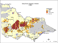
| A major factor governing the distribution of gullies in Victoria is the presence of erodible material in those landscape positions where concentrated surface or subsurface runoff can occur; i.e. confined alluvial deposits, unconsolidated sediments and deeply weathered rocks and sediments. Generally speaking, the highest incidence of gullying is usually found on cleared uplands which support erodible sodic duplex soils (Sodosols) in areas where the mean annual rainfall is at least 500 mm. The incidence of gully erosion around Nhill in the Wimmera region occurs where the rainfall is lower than 500 mm p.a. and is more likely to be a result of high rainfall events taking place when ground cover is minimal. Zones of very low gully density would be expected on broad alluvial plains, the undulating aeolian landscape (i.e. Mallee region), basalt plains and uncleared land. The cleared uplands to the southeast and southwest of Melbourne (including the Otway and Strzelecki ranges) receiving more than 1 000 mm of annual rainfall, tend not to be subject to gully erosion. The factors responsible involve various landscape (e.g. steep slopes and high drainage density) and soil characteristics (e.g. low subsoil sodicity, high infiltration rates and shallow soil depth). However, many of the small, steeper drainage lines in these areas are actively eroding but are not classified as gullies owing to their smaller dimensions. | 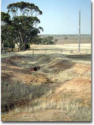 A gully near Nhill - initiated from a single heavy rainfall event. Photograph: Mark Imhof. |
Gully Density (km/km2) | Area Affected | |
(km2) | (%) | |
low | 179 750 | 79.0 |
low to 0.2 | 11 470 | 5.0 |
0.2 to 0.5 | 17 790 | 7.8 |
> 0.5 | 18 590 | 8.2 |
Total | 227 600 | 100.0 |
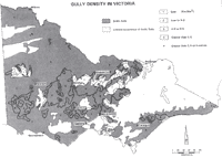 Gully density in relation to soil sodicity in Victoria (Ford et al., 1993). © CSIRO Reproduced with permission of CSIRO PUBLISHING. http://www.publish.csiro.au/journals/ajsr/ (external link) |
© State of Victoria (Agriculture Victoria) 1996 - .

This work, Victorian Resources Online, is licensed under a Creative Commons Attribution 4.0 licence. You are free to re-use the work under that licence, on the condition that you credit the State of Victoria (Agriculture Victoria) as author, indicate if changes were made and comply with the other licence terms.
The licence does not apply to ‘branding’ or some ‘images or photographs’ that may be owned by third parties. We ask you to seek prior approval to use images using the VRO feedback form. Access to higher quality images can also be provided on request.
This page was last updated on .