
Land Degradation - Costerfield District
An allotment which became both extensively and severely tunnelled allotment (see tunnel erosion) was surveyed on 17 June 1882 and covered an area of 319 acres, 1 rood and 10 perches (i.e. approximately 129.3 ha) (Boucher 2002, VPRS 626/P Unit No. 2083, File Reference: 3319/19.20, Public Record Office, Victoria).
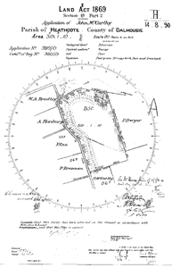 The survey plan of the allotment contained in file no. Public Record Office, Victoria No. VPRS 626/P Unit No. 2083, File Reference: 3319819.20. Reproduced with the permission of the Keeper of Public Records, Public Record Office (PDF 65KB) | The block was described by the surveyor as being 'rangy' and having a 'poor' cover of grass with stringy bark, box and iron bark, 'poor' soil and Silurian lithology. The following summary details the improvements listed between 1 February 1883 and 4 March 1889. The land was fully-enclosed and fencing comprised 40 chains (i.e. approximately 0.80 km) of chock and log and 2 miles and 25 chains (i.e. approximately 3.74 km) of log and brush. A dam was excavated to the dimension of 24' (i.e. approximately 7.3 m) by 24' and 5' (approximately 1.5 m) deep. The land was considerd as being 'unfit for cultivation' and ringbarking had been undertaken. An aerial photograph taken on 24 March 1949 reveals that tunnel and gully erosion were present and the distinction between various erosion features on part of the allotment is made clear using a photograph taken in 1971. |
 An aerial view of the allotment taken in 1949. Photograph reproduced courtesy of Geoscience Australia (PDF 448KB) | 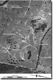 An enlarged view of part of the allotment taken in 1971. (This photograph is Copyright (c) Crown (State of Victoria) 2006. All rights reserved. It has been reproduced with the permission of the Surveyor General, Victoria). (PDF 666KB) |
To view the information PDF requires the use of a PDF reader. This can be installed for free from the Adobe website (external link).
© State of Victoria (Agriculture Victoria) 1996 - .

This work, Victorian Resources Online, is licensed under a Creative Commons Attribution 4.0 licence. You are free to re-use the work under that licence, on the condition that you credit the State of Victoria (Agriculture Victoria) as author, indicate if changes were made and comply with the other licence terms.
The licence does not apply to ‘branding’ or some ‘images or photographs’ that may be owned by third parties. We ask you to seek prior approval to use images using the VRO feedback form. Access to higher quality images can also be provided on request.
This page was last updated on .