Your gateway to a wide range of natural resources information and associated maps

Victorian Resources Online

Soils of the Cranbourne - Koo Wee Rup Region - West

Back to: Port Phillip & Westernport - Soils of the Cranbourne - Koo Wee Rup Region

Click on a unit name to get further information about each Mapping Unit and relevant soil types.
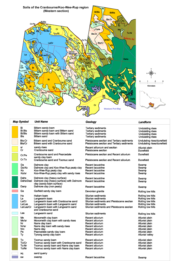
Map:  Soils of the Cranbourne/Koo Wee Rup Region West


Soils of the Cranbourne - Koo Wee Rup Region - West
Bi - Bittern sandy loamLa/LasLangwarrin loam with Langwarrin sand
Bi:Bis - Bittern sandy loam and Bittern sandLa/Las/Cr - Lanwarrin loam with Langwarrin sand and Cranbourne sand
Bi/Bis - Bittern sand loam with Bittern sandLas - Langwarrin sand
Bis - Bittern sandMn - Monomeith clay loam
Bis:Cr - Bittern sand and Cranbourne sandMn/sr - Monomeith clay loam with sandy rises
Bis/Cr - Bittern sand with Cranbourne sandNr - Narre clay loam
Cr - Cranbourne sandNr/sr - Narre clay loam with sandy rises
Cr:Pe - Cranbourne sand and Pearcedale sandy clay loamNrc - Narre clay
Da - Dalmore clayPe - Pearcedale sandy clay loam
Ko - Koo Wee Rup peaty clayTy - Tynong sandy clay loam
Ko/sr - Koo Wee Rup peaty clay with sandy risesTo - Toomuc sandy loam
Daha/Dasl - Dalmore clay (heavy surface) with Dalmore clay (sandy loam surface)To/Cr - Toomuc sandy loam with Cranbourne sand
Danp - Dalmore clay (non peaty)To:Nr - Toomuc sandy loam and Narre clay loam
Ga - Garfield sandy clay loamTo/Nr - Toomuc sandy loam with Narre clay loam
Ha - Hallam loamsw - swamp
La - Langwarrin loam
La/Cr - Langwarrin loam with Cranbourne sand


A high resolution version of the 'Soils of the Cranbourne - Koo Wee Rup Region - West' map (PDF 1.5 MB) is available to download

The high resolution PDF file provided on this page can be viewed using the free Adobe PDF reader, this software can be installed for free from the Adobe website (external link). This PDF is provided with a high level of detail and with the intent that it should be printed at a high resolution.

Page top