
Cranbourne Sand
Symbol: Cr
Geology - Pleistocene aeolian sediments comprising siliceous sand dunes and sheets.
Cranbourne sand is the main soil type occurring within the dunefields around Cranbourne. Areas of deep sand have been extensively quarried and the surface soil used for topdressing of lawns and playing fields. The immediate subsoil is often used as packing sand and the deep subsoil used for bricklaying and concrete production.
Landform - Dunefield
Soils - Cranbourne sand was named by Holmes et al. (1940). This soil typically has a dark grey sand surface becoming light grey by about 200 to 300 mm. Dark brown and yellow brown cemented sands (termed 'coffee rock') usually occur at about 1 m. Mottled light yellow-brown and light grey sands occur under the 'coffee rock', and mottled yellow-brown and light grey sandy clays occur at greater depths. Site GP 20 is an example of Cranbourne sand. These soils can be described as Pipey Podosols using the Australian Soil Classification system (Isbell 1996).
Typical profile of Cranbourne Sand
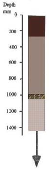 | 0 - 250 mm. Dark grey, or grey, sand or loamy sand, clear transition to: 250 mm - 1.0 m. Pale grey to pale greyish brown sand, which may become pale brown with depth, abrupt and wavy transition to: 1.0 m. Dark brown and yellow brown variably cemented sand, 50 to 100 mm thick, gradual transition to: 1.1 m continuing. Mottled light yellow-brown and grey sands, sandy clays at a variable depth. |
These soils are poor chemically, and because they are sandy they retain little water. However, with irrigation, fertilisers and additional organic matter they become highly productive. The main attraction of these soils is that they can be cultivated over most of the year. This capability makes these soils the most sought after for vegetable cropping.
The 'coffee rock' layer can sometimes impede the downward movement of water, in which case subsurface drainage may be required.
Cranbourne sand and Toomuc sandy loam
Symbol: Cr:To
This mapping unit describes areas which comprise both Cranbourne sand and Toomuc sandy loam. The proportion of each soil ranges between 30 and 70% of the total area.
Cranbourne sand and Pearcedale sandy clay loam
Symbol: Cr:Pe
This mapping unit describes areas which comprise both Cranbourne sand and Pearcedale sandy clay loam. The proportion of each soil ranges between 30 and 70% of the total area.
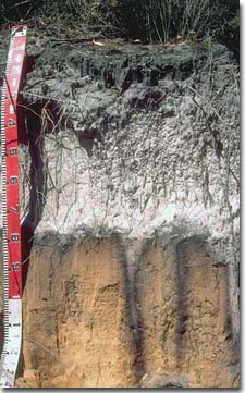 | Roadside cutting near Pearcedale showing Cranbourne sand profile. Note the deep bleached A2 horizon and 'coffee rock' zone overlying yellow sand. This soil has distinctive 'pipes' of subsurface (A2) soil material penetrating through the 'coffee rock'. |

© State of Victoria (Agriculture Victoria) 1996 - .

This work, Victorian Resources Online, is licensed under a Creative Commons Attribution 4.0 licence. You are free to re-use the work under that licence, on the condition that you credit the State of Victoria (Agriculture Victoria) as author, indicate if changes were made and comply with the other licence terms.
The licence does not apply to ‘branding’ or some ‘images or photographs’ that may be owned by third parties. We ask you to seek prior approval to use images using the VRO feedback form. Access to higher quality images can also be provided on request.
This page was last updated on .