
Port Phillip and Westernport Region Soil Pits
A number of soil pits have been characterised and described associated with various Departmental projects within the Port Phillip and Westernport Region.
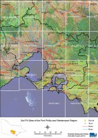 Port Phillip and Westernport Region Soil Pits - Mapsheet Grid | This is a clickable map of the Port Phillip and Westernport Region of Victoria. Click on this regional map to access the Port Phillip and Westernport mapsheet grid that highlights the soil pits characterised in this region. |
Port Phillip and Westernport Region Soil Pit Sites
NOTE: This page is under construction, some pit sites do not have data linked to them at present.
| BACCHUS MARSH MAPSHEET | |||||||||
| PPW10 | PPW11 | ESAS11a | YP5 | ||||||
| MELBOURNE MAPSHEET | |||||||||
| ASSS20 | ASSS21 | ASSS22 | LSQ1 | ||||||
| PPW1 | PPW2 | PPW3 | PPW4 | PPW5 | PPW6 | PPW7 | PPW8 | PPW9 | |
| HUCC1 | HUCC2 | HUCC3 | HUCC4 | HUCC5 | HUCC6 | HUCC7 | |||
| RINGWOOD MAPSHEET | |||||||||
| ASSS15 | ASSS16 | ASSS17 | ASSS18 | ASSS19 | |||||
| SORRENTO MAPSHEET | |||||||||
| MOP3 | |||||||||
| WARRAGUL MAPSHEET | |||||||||
| ASSS14 | GW03 | ||||||||
| GP26 | GP27 | GP28 | GP52 | GP55 | GP56 | GP79 | GP80 | GP81 | GP82 |
| SPDS1 | SPDS2 | ||||||||
| WESTERNPORT MAPSHEET | |||||||||
| ASSS2 | ASSS3 | ASSS4 | ASSS5 | ASSS6 | ASSS7 | ASSS8 | ASSS9 | ASSS10 | ASSS11 |
| ASSS12 | ASSS13 | ||||||||
| GP20 | GP21 | GP22 | GP23 | GP24 | GP25 | GP53 | GP54 | GP57 | GP58 |
| GP59 | GP60 | GW01 | GW02 | ||||||
| MOP1 | MOP2 | MOP4 | MOP5 | MOP6 | MOP7 | ||||

© State of Victoria (Agriculture Victoria) 1996 - .

This work, Victorian Resources Online, is licensed under a Creative Commons Attribution 4.0 licence. You are free to re-use the work under that licence, on the condition that you credit the State of Victoria (Agriculture Victoria) as author, indicate if changes were made and comply with the other licence terms.
The licence does not apply to ‘branding’ or some ‘images or photographs’ that may be owned by third parties. We ask you to seek prior approval to use images using the VRO feedback form. Access to higher quality images can also be provided on request.
This page was last updated on .