
Langwarrin loam
Symbol: La
Geology - Silurian sediments or on material derived from these sediments.
Landform - Rolling low hills.
Soils - This soil is identical to Hallam loam but is so named because of its locality, which is in the west of the surveyed area. The surface soil is a grey or light grey loam to silty loam about 150 mm deep. It is likely to set very hard. This overlies a paler grey to brownish grey similarly textured subsurface horizon, often with iron nodules just above the subsoil clay. This horizon also becomes hard when dry. The subsoil generally occurs at about 400 mm to 500 mm and is generally a mottled light brownish grey and yellow-brown medium to heavy clay. On the slopes, weathered rock occurs at a depth of about 1.0 to 1.5 m.
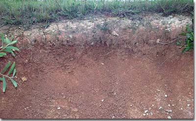 | Roadside cutting near Langwarrin showing soil profile which has developed on Silurian sediments. Note the presence of a deep bleached A2 horizon overlying a clayey subsoil. This profile occurs in a well-drained position and is consequently redder in colour than a more poorly drained soil profile. |
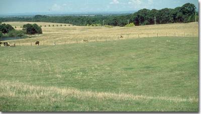 | Typical rolling hills landscape which has developed on Silurian sediments. Langwarrin loam and Hallam loam soils have formed on such landscapes. |
Typical profile of Langwarrin loam
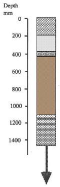 | 0 - 150 mm. Grey loam or silty loam, clear transition to: 150 - 400 mm. Light grey slity loam to clay loam often with concretions of ironstone just above the clay, clear transition to: 400 mm continuing to decomposing rock. Brownish grey with yellow-brown mottles medium to heavy clay. Red-brown mottles with depth. Decomposing siltstone or mudstone generally occurs before 2m. |
Although this soil is well drained externally, its internal drainage is very slow because of the impermeable clay subsoil. During the wetter parts of the year the subsurface becomes waterlogged. When wet, the surface soil tends to "run together" and sets hard on drying. This soil type is usually not well suited for intensive vegetable production. The soils here are either unused or used for grazing of cattle and horses.
Similar soils occur on Silurian sediments in the Yarra Valley and north of Pakenham. Here they are used for vineyards, orchards, flower growing and market gardens, mainly winter growing cruciferous crops such as cabbages, cauliflowers and broccoli.
Langwarrin loam with Cranbourne sand
Symbol: La/Cr
This mapping unit describes areas which comprise mostly Langwarrin sand with some Cranbourne sand. The percentage of the dominant soil, Langwarrin sand, is at least 70% of the total area.
Langwarrin loam with Langwarrin sand and Cranbourne sand
Symbol: La/Las/Cr
This mapping unit describes areas which comprise mostly Langwarrin loam with some Langwarrin sand and Cranbourne sand. The percentage of the dominant soil, Langwarrin loam, is at least 70% of the total area.
Langwarrin loam with Langwarrin sand
Symbol: La/Las
This mapping unit describes areas which comprise mostly Langwarrin loam with some Langwarrin sand. The percentage of the dominant soil, Langwarrin loam, is at least 70% of the total area.

© State of Victoria (Agriculture Victoria) 1996 - .

This work, Victorian Resources Online, is licensed under a Creative Commons Attribution 4.0 licence. You are free to re-use the work under that licence, on the condition that you credit the State of Victoria (Agriculture Victoria) as author, indicate if changes were made and comply with the other licence terms.
The licence does not apply to ‘branding’ or some ‘images or photographs’ that may be owned by third parties. We ask you to seek prior approval to use images using the VRO feedback form. Access to higher quality images can also be provided on request.
This page was last updated on .