
Narre clay loam
Symbol: Nr
Geology - Recent alluvium
Landform - Alluvial plain
Soils
This soil occurs in the lower parts of the landscape and in areas adjoining the western and northern parts of the former swamp. It was first described by Holmes et al. (1940) and is essentially similar to the "Swamp Fringe Type" described by Goudie (1942).
Most of the soils are dark brownish grey to dark greyish brown clay loams to sandy clay loams overlying, at about 250 mm, brownish grey to greyish brown with rusty brown mottled sandy clay loams to light clays. This layer is generally, but not always, bleached. Mottled grey and brown medium to heavy clays occur from about 400 mm and extend to at least 1.8 m. The depth to the clay may vary from 200 mm to 500 mm. On the higher parts of the landscape adjoining the drainage lines the soil profile may be sandier. Soil Pit Site GP27 is an example of a sandier soil profile within the Narre clay loam mapping unit.
It should be noted that small areas of Toomuc sandy loam may also occur within this mapping unit.
Typical profile of Narre clay loam
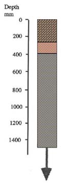 | 0 - 250 mm. Dark greyish brown clay loam, clear transition to: 250 - 400 mm. Greyish brown mottled with rusty brown sandy clay loam to light clay, abrupt transition to: 450 mm continuing. Brown and grey mottled medium to heavy clay. |
External drainage is generally poor on these soils and in many situations surface ponding occurs after rain. These soils are rarely cultivated and are mainly used for grazing cattle.
However, when Narre clay loam occurs in drainage depressions within areas of sandy soils such as Cranbourne sand and Bittern sand, the surface soil is deeper and generally a sandy clay loam. Given good external drainage these areas can support horticultural crops.
Narre clay loam with sandy ridges
Symbol: Nr/sr
Areas on the soil map delineated "with sandy ridges" indicate that about 20% of the area is comprised mostly of gravelly to sandy soils. These sandy ridges are the remnants of the beds and levees of streams that flowed from the Eastern Highlands. The distribution of sandy ridges can be seen from an aerial photo taken in an area with Koo-Wee-Rup peaty clay and Narre clay loam.

© State of Victoria (Agriculture Victoria) 1996 - .

This work, Victorian Resources Online, is licensed under a Creative Commons Attribution 4.0 licence. You are free to re-use the work under that licence, on the condition that you credit the State of Victoria (Agriculture Victoria) as author, indicate if changes were made and comply with the other licence terms.
The licence does not apply to ‘branding’ or some ‘images or photographs’ that may be owned by third parties. We ask you to seek prior approval to use images using the VRO feedback form. Access to higher quality images can also be provided on request.
This page was last updated on .