
Waygara (Symbol: Wy)
EG220 | EG221 | EG248 | EG249 | EG250 | EG251 | Site 147 (Rees unpublished) | Site 153 (Rees unpublished)
Geology
Neogene (late Tertiary) alluvial sediments. The Tertiary sediments form the oldest ‘terraces’ and outwash fans from the uplands. The soils close to the Eastern Highlands the soil profile often has a gravelly component, but further south the soils are finer textured, with loamy fine sands to fine sandy loams overlying clays.
This early depositional sequence has been strongly dissected over time and sands, probably windblown from the many drainage lines, cover about 10 – 30% of the area. These soils often have organic matter and iron cemented sands in the subsoil, generally from about 70 cm – 1m.
Landform
The Waygara map unit encompasses undulating rises to rolling low hills. In the late Tertiary it is most likely that the area was an alluvial plain but since then this has been dissected and subject to periods of aridity, resulting in areas of deep sand cover. Consequently the map unit may be subdivided into two components.
Original vegetation
Lowland forest.
Soils
Component 1
Most of the soils of the Waygara map unit are texture contrast soils. The surface soils are strongly to moderately acidic and range from dark greyish brown loamy sands to sandy loams generally with a bleached subsurface soil. Brown medium to heavy clays, which are generally strongly to moderately acidic, occur at a variable depth, generally before 50 cm, typically with yellowish brown, grey or strong brown mottles. The sandy surface soils have a low nutrient and water holding capacity where the organic matter levels are low and are also prone to wind erosion; see EG 221, EG 248, EG 249, EG 250, EG 251. Areas of soils with sandy clay loam subsoils may also occur (Newell and Woodruff, 1962); see Site 147 Rees (unpublished).
Component 2
About 10 – 30% of the area is covered by deep sand generally with organic matter and iron cemented sands in the subsoil. In the Newell and Woodruff report (1962) it is called the Tostaree map unit (See EG 220).
Land use
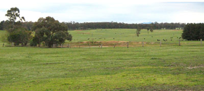
Areas which have been cleared are used for grazing, but most of the uncleared land is public land and subject to forestry or is national park.
Previous maps and reports
A reconnaissance of soil and vegetation was made of an area south of Princes Highway between the Nowa Nowa River and Newmerella comprising about 20 250 ha, as well as a detailed survey of about 450 ha was made by J. W. Newell and B. J. Woodruff in 1962. This report is titled ‘Soils and Vegetation in the Hartland Area’, Soil Survey Report 34, Soils Section, Department of Agriculture.
Site EG220
| Location: Lake Tyers | Geo. Ref. 0597100E 5813000N |
| Australian Soil Classification: Melacic, Humosesquic, Aeric PODOSOL | Uniform textured deep sand |
| General landscape description: Undulating rises | |
| Geology: Tertiary sediments | |
| Site description: Simple mid slope 3%, north east aspect | |
| Land use: Grazing | |
| Native vegetation: Lowland forest | |
| Mapping unit: Waygara (Component 2) |
Soil profile morphology
| Surface soil |  | ||
A11 | 0 – 25 cm | Very dark grey (10YR3/1); sand; apedal, single grain structure; diffuse change to: | |
A12 | 25 – 60 cm | Dark grey (10YR4/1); sand; apedal, single grain; clear change to: | |
A2 | 60 – 75 cm | Greyish brown (10YR5/2); sand; apedal, single grain; diffuse change to: | |
Subsoil | |||
Bhs | 75 – 95 cm | Greyish brown (10YR5/2); sand; apedal, single grain; with pockets of a mainly very dark brown (10YR3/2) weakly cemented organic pan; clear change to: | |
C | 95 – 120 cm | Light brownish grey (10YR6/2); sand; apedal, single grain. | |
Key profile features
| |||
Soil profile characteristics
| pH | Sodicity | Slaking | Dispersion Dry | Dispersion Remoulded | |
| Surface soil (A1 horizon) | Strongly acid | Non sodic | Minimal aggregation | Minimal aggregation | Minimal aggregation |
| Subsurface (A2horizon) | Strongly acid | Non sodic | Minimal aggregation | Minimal aggregation | Minimal aggregation |
| Deeper subsoil (70-95 cm) | Moderately acid | Non sodic | Minimal aggregation | Minimal aggregation | Minimal aggregation |
| Horizon | Depth cm | Field texture | pH water | pH CaCl2 | EC dS/m | Coarse sand % | Fine sand % | Silt % | Clay % | Field cap. % w/w | Wilt. point % w/w | PAW* water % w/w |
| A1 | 0-25 | S | 5.3 | 4.2 | <0.05 | 69 | 20 | 1 | 2 | 10.6 | 5.4 | 5.2 |
| A2 | 25-60 | S | 5.5 | 4.3 | <0.05 | 68 | 24 | 1 | 2 | 8.4 | 1.5 | 6.9 |
| A3 | 60-75 | S | 5.9 | 4.8 | <0.05 | 64 | 27 | 1 | 3 | 6.7 | 1.2 | 5.5 |
| Bhs | 75-95 | S | 6.0 | 5.0 | <0.05 | 58 | 30 | 4 | 4 | 9.2 | 2.4 | 6.8 |
| Depth | OrgC# | Total N | Free Fe2O3 | Exch. Al | Exchangeable cations cmol(+)/kg | Ca:Mg | ESP | ||||||
| cm | % | % | % w/w | ppm | Ca | Mg | K | Na | Total | H | CEC | ||
| 0-25 | 1.8 | <10 | 2.2 | 0.77 | 0.18 | 0.1 | 3.2 | 7.1 | 10.3 | 2.8 | 1 | ||
| 25-60 | 0.66 | <0.05 | 20 | 0.76 | 0.22 | <0.05 | 0.06 | 1.1 | 4.0 | 5.1 | 3.4 | 1 | |
| 60-75 | <0.30 | <0.05 | <10 | 0.55 | 0.38 | <0.05 | 0.08 | 1.1 | 1.4 | 2.5 | 1.4 | 3 | |
| 75-95 | 0.5 | <0.05 | <10 | 1.1 | 1.4 | <0.05 | 0.18 | 2.6 | 4.9 | 7.5 | 0.8 | 2 | |
Management considerations
Whole profile
- If the soil is under pasture with an effective rooting depth of 70 cm, the plant available water capacity is considered to be low (estimated at 52 mm). Because of the low wilting points throughout the profile, plants will be able to use very light rains when the soil is dry. Due to the low water storage capacity of the soil, plants will suffer water stress unless further rains occur.
- The soil has a low organic matter content, but there are sufficient coarse roots to hold the soil together.
- The soils are strongly acidic and, if under pasture, may show a response to lime. Test strips should be first used to evaluate the cost/benefits.
- The nutrient holding capacity of the soil is very low (based on the sum of the exchangeable basic cations).
- Potassium levels are deficient and a strong response to potassium fertilizers would be expected if the soils are under pasture.
- Even though this layer is cemented, it is sufficiently porous and well drained.
| Location: Lake Tyers | Geo. Ref. 597003E 5812972N |
| Australian Soil Classification: Bleached Sodic, Magnesic, Brown KUROSOL | Sodic brown texture contrast soil |
| General landscape description: Undulating rises | |
| Geology: Neogene sediments (Late Tertiary) | |
| Site description: Simple upper slope 2%, north east aspect | |
| Land use: Grazing | |
| Native vegetation: Lowland forest | |
| Mapping unit: Waygara |
Soil profile morphology
| Surface soil | 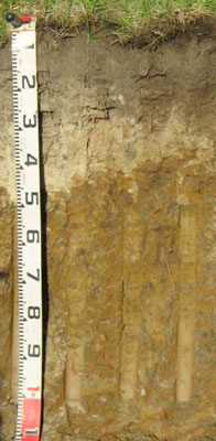 | ||
A1 | 0 – 20/30 cm | Dark greyish brown (10YR4/2); sandy loam; weak medium (10 – 20 mm) polyhedral structure; firm moist; clear wavy change to: | |
A2 | 20/30 – 50/35 cm | Pale brown (10YR6/3) conspicuously bleached (10YR/8/1d); sandy loam or loamy sand; apedal, single grain; firm consistence dry; sharp change to: | |
Subsoil | |||
B21 | 50/35 – 80 cm | Yellowish brown (10YR5/6); heavy clay; moderate coarse (20 – 50 mm) polyhedral structure; strong consistence moist; diffuse change to: | |
B22 | 80 – 110 cm | Yellowish brown (10YR5/6) with greyish brown (10YR5/2) and increasing yellowish red (5YR5/6) mottles; heavy clay; moderate coarse (20 – 50 mm) lenticular structure; strong consistence moist. | |
Key profile features
| |||
Soil profile characteristics
| pH | Sodicity | Slaking | Dispersion Dry | Dispersion Remoulded | |
| Surface soil (A1 horizon) | Moderately acid | Non sodic | Water stable | Nil (2 hours), Nil (20 hours) | Nil (2 hours), Nil (20 hours) |
| Subsoil (B21 horizon) | Strongly acid | Sodic | Partial | Slight (2 hours), Slight (20 hours) | Nil (2 hours), Slight (20 hours) |
| Deeper subsoil (80-110 cm) | Strongly acid | Strongly sodic | Considerable | Nil (2 hours), Nil (20 hours) | Slight (2 hours), Slight (20 hours) |
| Horizon | Depth cm | Field texture | pH water | pH CaCl2 | EC dS/m | Coarse sand % | Fine sand % | Silt % | Clay % | Field cap. % w/w | Wilt. point % w/w | PAW* water % w/w |
| A1 | 0-20/30 | SL | 5.9 | 4.6 | 0.06 | 43 | 29 | 11 | 8 | 12.9 | 5.7 | 7.2 |
| A2 | 20/30-50/35 | LS | 5.3 | 4.1 | <0.05 | 48 | 29 | 12 | 6 | 13.9 | 3.0 | 10.9 |
| B21 | 50/35-80 | HC | 5.0 | 4.0 | <0.05 | 12 | 14 | 13 | 59 | 39.2 | 22.3 | 16.9 |
| B22 | 80-110 | HC | 5.4 | 4.4 | <0.05 | 15 | 13 | 15 | 54 | 36.5 | 20.8 | 15.7 |
| Depth | Org C# | Total N | Free Fe2O3 | Exch. Al | Exchangeable cations cmol(+)/kg | Ca:Mg | ESP | ||||||
| cm | % | % | % w/w | ppm | Ca | Mg | K | Na | Total | H | CEC | ||
| 0-20/30 | 2.9 | 0.16 | 22 | 3.3 | 1.3 | 1 | 0.27 | 5.9 | 10.0 | 15.9 | 2.6 | 2 | |
| 20/30-50/35 | 0.57 | <0.05 | 74 | 0.51 | 0.33 | 0.15 | 0.12 | 1.1 | 3.6 | 4.7 | 1.5 | 3 | |
| 50/35-80 | 0.49 | <0.05 | 530 | 0.67 | 5.6 | 0.51 | 1.3 | 8.1 | 13.0 | 21.1 | 0.1 | 6 | |
| 80-110 | 0.37 | <0.05 | 110 | 0.21 | 9.9 | 0.32 | 3.2 | 14 | 8.0 | 22.0 | <0.1 | 15 | |
Management considerations
Whole Profile
- The plant available water capacity of the soil is considered to be low (estimated at 54 mm) for the top 50 cm of the soil profile.
- The dense and coarsely structured subsoil is likely to restrict root movement.
- The sand surface horizons are very well draining but have a low water storage capacity. The low wilting points (i.e. 5.7 and 3.0) indicate plants will be able to utilise light rains falling on dry soil. However, due to the low water storage capacity, plants will soon suffer moisture stress unless further rain occurs. Organic matter is an important source of nutrient holding capacity as well as enhancing water holding capacity in sandy soils.
- The sandy surface soil will also be prone to wind erosion if plant cover is removed where blow-outs can occur.
- The surface horizons have a moderate inherent fertility (based on the sum of the exchangeable cations).
- The surface soil is quite high in potassium and no response to potassium fertilisers would be expected.
- The dense and coarsely structured upper (B21) subsoil is sodic. This will restrict the downward movement of plant roots and water. The temporary build up of water on top of this less permeable layer may be beneficial for deeper-rooted plants as it prevents deep drainage of water away from plant roots.
- Sodic subsoils are typically moderately to strongly dispersive, but here are only slightly dispersive, mainly due to the high exchangeable aluminium.
- The upper (B21) subsoil has a relatively moderate inherent fertility throughout (based on the sum of the exchangeable calcium, magnesium and potassium cations). The cations are dominated by exchangeable magnesium which may create nutrient imbalances.
- The level of soluble salts is low.
| Location: Tostaree | Geo. Ref. 0604500E 5817500N |
| Australian Soil Classification: Bleached-Mottled, Eutrophic, Brown KUROSOL (Thick sandy surface horizons) | Brown texture contrast soil |
| General landscape description: Undulating rises | |
| Geology: Tertiary sediments | |
| Site description: 3% slope to east | |
| Land use: Plantation forest (Site CFTT 03) | |
| Native vegetation: Lowland forest | |
| Mapping unit: Waygara |
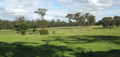
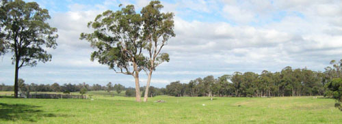
Landscape typical of this map unit near Newmerella
Soil profile morphology
| Surface soil | 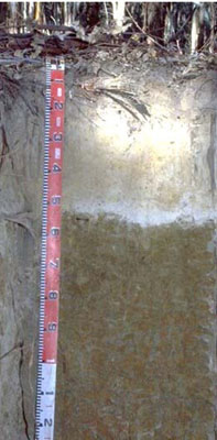 | ||
A1 | 0 – 15 cm | Very dark greyish brown (10YR3/2); loamy fine sand; weak fine granular structure; very weak consistence moist: clear and wavy transition to: | |
A2 | 15 – 55 cm | Light yellowish brown (10YR6/4), conspicuously bleached (10YR7/3d); loamy fine sand; very weak consistence dry; sharp and wavy transition to: | |
Subsoil | |||
B21 | 55 – 100 cm | Dark yellowish brown (10YR4/6) with common, coarse, distinct yellowish red (5YR4/6) mottles; light medium clay; moderate coarse subangular blocky structure; very firm consistence moist; gradual and smooth change to: | |
B22 | 100 – 140 cm | Red (2.5YR4/6, with many, coarse, prominent dark yellowish brown (10YR4/6) and light brownish grey (10YR106/2) mottles; mottling becoming more pronounced with depth; light medium clay; strong medium prismatic structure; strong consistence moist. | |
Key profile features
| |||
Soil profile characteristics
| pH | Salinity rating | Sodicity | Dispersion | Slaking | |
| Surface soil (A1 horizon) | Strongly acid | Very low | Non sodic | None | |
| Subsoil (B21 horizon) | Strongly acid | Very low | Non-Sodic | None | |
| Deeper subsoil (at 1 m) | Strongly acid | Very low | Non-Sodic | None |
| Horizon | Depth cm | Field texture | pH water | pH CaCl2 | EC dS/m | Coarse sand % | Fine sand % | Silt % | Clay % | Field cap. % w/w | Wilt. point % w/w | PAW* water % w/w |
| A1 | 0-15 | LFS | 5.3 | 4.3 | 0.08 | 28 | 44 | 13 | 9 | 17.9 | 8.4 | 9.5 |
| A2 | 15-55 | LFS | 5.4 | 4.6 | <0.05 | 32 | 48 | 15 | 6 | 15.5 | 2.3 | 13.2 |
| B21 | 55-100 | LMC | 5.5 | 4.9 | 0.11 | 3 | 9 | 4 | 83 | 49.1 | 31.0 | 18.1 |
| B22 | 100-140 | LMC | 5.5 | 4.7 | <0.05 | 1 | 20 | 7 | 71 |
| Depth | Org C | Total N | Free Fe2O3 | Exch Al | Exchangeable cations cmol(+)/kg | Ca:Mg | ESP | ||||||
| cm | % | % | % w/w | ppm | Ca | Mg | K | Na | Total | H | CEC | ||
| 0-15 | 160 | 0.81 | 0.93 | 0.18 | 0.19 | 2.1 | 16.0 | 18.1 | 0.9 | 1 | |||
| 15-55 | 22 | 0.33 | 0.19 | 0.08 | 0.06 | 0.66 | 2.3 | 3.0 | 1.7 | 2 | |||
| 55-100 | 27 | 1.4 | 11.0 | 0.13 | 1.1 | 13.6 | 13.0 | 26.6 | 0.13 | 4 | |||
Management considerations
- The subsoil has low calcium and a low calcium to magnesium ratio. Calcium deficiencies may occur as a result.
- The soil profile is strongly acid throughout. The availability of some elements (eg copper and molybdenum) may be low as a result. Aluminium toxicity can be a problem in strongly acid soils and the level here is likely to affect phosphorus availability. The use of test strips to see whether the addition of lime is going to be economical is recommended if the soil is to be used for pasture.
- Potassium is low and deficient and a response to potassium fertilizer would be expected.
| Location: Waygara | Geo. Ref. 0615500E 582900N |
| Australian Soil Classification: Bleached-Mottled, Magnesic, Yellow CHROMOSOL | Yellow texture contrast soil |
| General landscape description: Undulating rises | |
| Geology: Tertiary sediments | |
| Site description: Level plain | |
| Land use: Native forest (Site CFTT 04) | |
| Native vegetation: Lowland forest | |
| Mapping unit: Waygara |
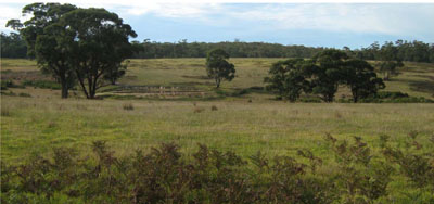
Landscape photo typical of this unit 7 km south of the sample site
Soil profile morphology
| Surface soil | 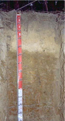 | ||
A1 | 0 – 15 cm | Dark grey (10YR4/1); fine sandy clay loam; weak medium granular structure; weak consistence moist; clear smooth change to: | |
A2 | 15 – 52 cm | Very pale brown (10YR7/4); conspicuously bleached; fine sandy clay loam; massive; weak consistence moist; clear smooth change to: | |
Subsoil | |||
B1 | 52 – 60 cm | Brownish yellow (10YR6/6); with common medium faint yellowish brown (10YR5/4) mottles; sandy clay; massive; weak consistence moist; clear wavy change to: | |
B21 | 60 – 90 cm | Light yellowish brown (10YR6/4), with many coarse distinct red (2.5YR4/6) mottles; light medium clay; moderate coarse polyhedral structure parting to moderate medium polyhedral structure; very firm consistence moist; diffuse change to: | |
B22 | 90 – 140 cm | Grey (10YR6/1) with many coarse prominent dark yellowish brown (10YR4/6) mottles; light medium clay; moderate coarse prismatic parting to fine polyhedral structure. |
Soil profile characteristics
| Horizon | Depth cm | Field texture | pH water | pH CaCl2 | EC dS/m | Coarse sand % | Fine sand % | Silt % | Clay % | Field cap. % w/w | Wilt. point % w/w | PAW* water % w/w |
| B21 | 60-90 | LMC | 5.9 | 5.1 | 0.05 | 21 | 16 | 12 | 50 | 32.4 | 19.1 | 13.3 |
| B22 | 90-140 | LMC | 5.7 | 4.8 | 0.07 | 15 | 14 | 11 | 57 | 30.6 | 22.3 | 8.3 |
| Depth | Org C | Total N | Free Fe2O3 | Exch Al | Exchangeable cations cmol(+)/kg | Ca:Mg | ESP | ||||||
| cm | % | % | % w/w | ppm | Ca | Mg | K | Na | Total | H | CEC | ||
| 60-90 | <10 | <0.05 | 7.9 | 0.07 | 0.65 | 8.6 | 8.6 | 17.2 | <0.1 | 4 | |||
| 90-140 | 32 | <0.05 | 8.6 | 0.06 | 0.91 | 9.6 | 9.9 | 19.5 | <0.1 | 5 | |||
Management considerations
- The calcium and potassium levels in the subsoil are extremely low, but the levels nearer the surface are not known.
- The subsoil has low calcium as well as a low calcium to magnesium ratio. Calcium deficiencies may occur as a result.
| Location: Waygara | Geo. Ref. 604500E 5817500N |
| Australian Soil Classification: Grey CHROMOSOL or KUROSOL (depends on pH) | Grey texture contrast soil |
| General landscape description: Undulating plain | |
| Geology: Tertiary sediments | |
| Site description: 4% slope to east | |
| Land use: Hardwood plantation (Site CFTT 01) | |
| Native vegetation: Lowland forest | |
| Mapping unit: Waygara |
Soil profile morphology
| Surface soil | 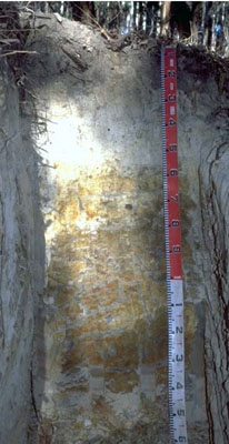 | ||
A1 | 0 – 15 cm | Very dark greyish brown (10YR3/2); loamy fine sand; weak coarse granular structure; very weak consistence moderately moist; clear and wavy change to: | |
A2 | 15 – 50 cm | Pale brown (10YR6/3), conspicuously bleached (10YR67/2 dry); loamy fine sand; massive; very weak consistence dry; clear and wavy change to: | |
A3 | 50 – 55/65 cm | Greyish brown (10YR5/2), many, coarse, distinct, yellowish brown (10YR5/6) and strong brown (7.5YR4/6) mottles; sandy clay loam; massive; weak consistence dry; abrupt and wavy change to: | |
Subsoil | |||
B21 | 55/65 – 110 cm | Light brownish grey (10YR6/2), many, very coarse, prominent strong brown (7.5YR5/6) mottles; light medium clay; moderate coarse polyhedralstructure, parting to moderate medium polyhedral structure; strong consistence moist; diffuse and smooth change to: | |
B22 | 110 – 150 cm | Grey (10YR5/1), many, very coarse, prominent strong brown (7.5YR5/6) and red (2.5YR4/6) mottles; light medium clay; moderate to coarse polyhedral structure, parting to moderate coarse polyhedral structure; strong consistence moist; veins of similarly coloured sandy clay appear with depth. |
Site EG251
| Location: Tostaree | Geo. Ref. 604500E 5817500N |
| Australian Soil Classification: Brown CHROMOSOL or KUROSOL (depends on pH) | Brown texture contrast soil |
| General landscape description: Undulating plain | |
| Geology: Tertiary sediments | |
| Site description: 6% slope to south | |
| Land use: Hardwood plantation (Site CFTT 02) | |
| Native vegetation: Lowland forest | |
| Mapping unit: Waygara |
Soil profile morphology
| Surface soil | 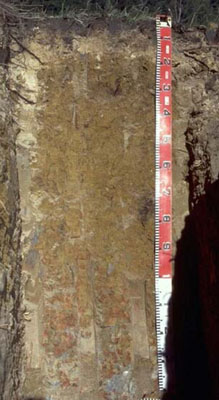 | ||
A1 | 0 – 8 cm | Very dark greyish brown (10YR3/2); loamy fine sand; weak fine granular structure; very weak consistence moderately moist; clear and wavy change to: | |
A2 | 8 – 15/20 cm | Pale brown (10YR6/3); loamy fine sand; very weak consistence dry; sharp and wavy change to: | |
Subsoil | |||
B21 | 15/20 – 85 cm | Yellowish brown (10YR5/4 and 10YR5/6); light medium clay; moderate very coarse angular blocky structure; strong consistence moist; diffuse and smooth change to: | |
B22 | 85 – 120 cm | Brown (10YR5/3), many, very coarse, prominent red (2.5YR4/6) mottles; light medium clay; moderate to very coarse angular blocky structure, parting to moderate medium angular blocky structure; strong consistence moist; diffuse and smooth change to: | |
B23 | 120 – 140 cm | Light grey (10YR6/1), with very many, very coarse, prominent dark red (2.5YR3/6) and yellowish brown (10YR5/6) mottles; sandy medium clay; moderate very coarse angular blocky structure, parting to moderate coarse angular blocky structure; fine subrounded quartz; strong consistence moist. |
Site 147 (Rees unpublished)
| Location: 2 km south of Cann River | Geo. Ref. 690000E 5838400N |
| Australian Soil Classification: Mottled, Mesotrophic, Brown KUROSOL | Acidic brown texture contrast soil |
| General landscape description: Undulating low hills | |
| Geology: Tertiary sediments | |
| Site description: Simple mid slope | |
| Land use: Native vegetation | |
| Native vegetation: Lowland forest | |
| Mapping unit: Waygara |
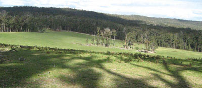
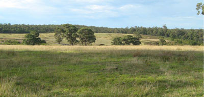
Photo taken on the west side of the Cann River Valley 4 km south of Cann River
Soil profile morphology
| Surface soil | ||
A11 | 0 – 20 cm | Dark greyish brown (10YR4/2); sandy loam; clear change to: |
A12 | 20 – 60 cm | Brownish yellow (10YR6/6); sandy loam; clear change to: |
Subsoil | ||
B2 | 60 – 90 cm | Strong brown (7.5YR5/6), few coarse red mottles; coarse sandy clay; apedal (single grain); diffuse change to: |
C | 90 – 110 cm | Strong brown (7.5YR5/6), with few coarse red mottles; sandy clay loam. |
Soil profile characteristics
| Horizon | Depth | Field texture | pH water | Exch Al | Org C | Exchangeable cations cmol (+)/kg | Ca:Mg | ||||||
| cm | ppm | % | Ca | Mg | K | Na | Total | H | CEC | ||||
| A!2 | 20-60 | FSL | 4.9 | 90 | 0.35 | 0.3 | 1.1 | 0.4 | 0.1 | 1.9 | 6.8 | 8.7 | 0.3 |
| B2 | 60-90 | KSC | 4.9 | 120 | 0.24 | 0.3 | 1.8 | 0.4 | 0.1 | 2.6 | 6.7 | 9.3 | 0.2 |
| C | 90-110 | SCL | 4.8 | 110 | 0.18 | 0.3 | 2.5 | 0.5 | 0.1 | 3.4 | 7.2 | 10.6 | 0.1 |
Site 153 (Rees unpublished)
| Location: 15 km south of Genoa, just south of Princes Highway | Geo. Ref. 717000E 5841400N |
| Australian Soil Classification: Bleached-Mottled, Magnesic, Brown KUROSOL | Acidic brown texture contrast soil |
| General landscape description: Undulating low hills | |
| Geology: Tertiary sediments | |
| Site description: Simple mid slope | |
| Land use: Native vegetation | |
| Native vegetation: Lowland forest | |
| Mapping unit: Waygara (Component 2) |
No photo available
Soil profile morphology
| Surface soil | 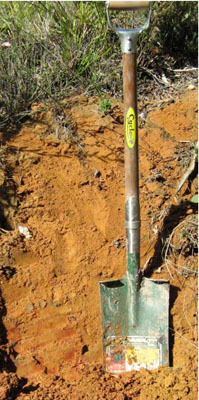 Red-brown sandy soil on Tertiary sediments. Photo taken near corner of Marlo-Cabbage Tree Road and Princes Highway | |||||||||||||||||||||||||||||||||||||||||||||||||||||||||||||||||||||||||||||||||||||
A11 | 0 – 5 cm | Dark greyish brown (10YR4/2); loamy sand; clear change to: | ||||||||||||||||||||||||||||||||||||||||||||||||||||||||||||||||||||||||||||||||||||
A12 | 5 – 15 cm | Light brownish grey (10YR6/2); loamy sand; clear change to: | ||||||||||||||||||||||||||||||||||||||||||||||||||||||||||||||||||||||||||||||||||||
Subsoil | ||||||||||||||||||||||||||||||||||||||||||||||||||||||||||||||||||||||||||||||||||||||
B2 | 15 – 35 cm | Brown (7.5YR5/4), few coarse red mottles; sandy clay; diffuse change to: | ||||||||||||||||||||||||||||||||||||||||||||||||||||||||||||||||||||||||||||||||||||
C | 35+ cm | Reddish yellow (7.5YR6/8), few coarse red mottles; coarse sandy clay. | ||||||||||||||||||||||||||||||||||||||||||||||||||||||||||||||||||||||||||||||||||||
Note: common (10 – 20%) medium quartz sand pebbles throughout the profile | ||||||||||||||||||||||||||||||||||||||||||||||||||||||||||||||||||||||||||||||||||||||
Soil profile characteristics
| ||||||||||||||||||||||||||||||||||||||||||||||||||||||||||||||||||||||||||||||||||||||
© State of Victoria (Agriculture Victoria) 1996 - .

This work, Victorian Resources Online, is licensed under a Creative Commons Attribution 4.0 licence. You are free to re-use the work under that licence, on the condition that you credit the State of Victoria (Agriculture Victoria) as author, indicate if changes were made and comply with the other licence terms.
The licence does not apply to ‘branding’ or some ‘images or photographs’ that may be owned by third parties. We ask you to seek prior approval to use images using the VRO feedback form. Access to higher quality images can also be provided on request.
This page was last updated on .