
CFTT1
| SITE: CFTT 1 | |
| Location: Mt Worth East | Aust. Soil Class.: Melacic (& Acidic), Dystrophic, Black DERMOSOL. |
| Great Soil Group: brown podsolic | General Landscape Description: Waning upper 10% slope to north-east. |
| Site Description: Eucalypt plantation. | Geology: Cretaceous sediments |
| Mapping Unit: Strzelecki. | |
Note: No landscape photo as the site is in the middle of a plantation forest.
Soil Profile Morphology:
Surface Soil
| A1 | 0 – 20 cm | Very dark brown (10YR2/2) clay loam; strong medium granular structure; very weak consistence moist; pH 4.4; gradual and smooth transition to: | 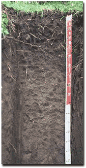 | |
| Subsoil | ||||
| B21 | 20 - 50 cm | Dark brown (7.5YR3/2) light clay; moderate medium polyhedral structure; very weak consistence moist; pH 4.5; diffuse and smooth transition to: | ||
| B22 | 50 – 90 cm | Dark brown (7.5YR3/2) light clay; moderate medium polyhedral structure; weak consistence moist; pH 4.6; diffuse and smooth transition to: | ||
| B23 | 90 – 140 cm | Dark brown (10YR4/3) light medium clay; moderate coarse polyhedral structure; weak consistence moist; pH 4.6; gradual transition to | ||
| B24 | 140-180 cm | Yellowish brown (10YR5/4) light clay; moderate coarse polyhedral structure; weak consistence moist; pH 4.6. | ||
Key Profile Features:
- Lack of strong texture contrast between surface (A) horizon and subsoil (B) horizons
Soil Profile Characteristics:
pH | Salinity Rating | |||
Surface (A1 horizon) | Extremely acid | Very low | Non-sodic | none |
Subsoil (B21 horizon) | Very strongly acid | Very low | Non-sodic | none |
Deeper subsoil (at 1.4 m +) | Very strongly acid | Very low | Non-sodic | none |
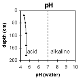 | This profile is strongly acid throughout. | 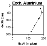 | The aluminium levels are high throughout the profile. |
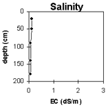 | The salinity rating is very low though the whole profile. | 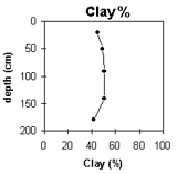 | The clay content is low in the surface, and sharply increases at the A/B interface. |
Horizon | Horizon Depth (cm) | pH (water) | pH CaCl2 | EC (dS/m) | Exchangeable Cations | |||
Ca | Mg | K | Na | |||||
meq/100g | ||||||||
A1 | 0-20 | 4.4 | 4 | 0.12 | 1 | 0.95 | 1.3 | 0.23 |
B21 | 20-50 | 4.5 | 4.1 | 0.12 | 0.41 | 0.43 | 1.2 | 0.3 |
B22 | 50-90 | 4.6 | 4.1 | 0.08 | 0.47 | 0.39 | 0.89 | 0.23 |
B23 | 90-140 | 4.6 | 3.9 | 0.07 | 1.4 | 1.3 | 0.46 | 0.17 |
B24 | 140-180 | 4.6 | 3.9 | 0.07 | 1.8 | 2.2 | 0.31 | 0.24 |
Horizon | Horizon Depth (cm) | Acidity meq/100g | Exchangeable Aluminium mg/kg | Field Capacity pF2.5 | Wilting Point pF4.2 | Coarse Sand (0.2-2.0 mm) | Fine Sand (0.02-0.2 mm) | Silt (0.002-0.02 mm) | Clay (<0.002 mm) |
A1 | 0-20 | 31 | 180 | 48.6 | 26.7 | 3 | 14 | 28 | 45 |
B21 | 20-50 | 30 | 190 | 47.2 | 24.9 | 1 | 13 | 26 | 49 |
B22 | 50-90 | 29 | 170 | 42.4 | 23.5 | 1 | 13 | 28 | 51 |
B23 | 90-140 | 31 | 140 | 38.8 | 22.4 | 0.3 | 14 | 31 | 50 |
B24 | 140-180 | 32 | 120 | 40.7 | 20.4 | 0.2 | 18 | 38 | 42 |
Management Considerations:
- The soil pit was excavated to 2 metres depth. No physical impeding layers were evident. The soil profile is friable throughout when moist and should provide good conditions for root movement.
- The upper soil profile has high levels of exchangeable potassium (K) relative to other basic cations (37% in surface soil and 50% in upper subsoil).
- The soil profile has high wilting point values. This indicates that plants will be unable to extract soil moisture when levels are low.
- The surface soil has a high clay content – making it susceptible to compaction from heavy trafficking or overstocking when in a moist to wet condition.
- Availability of some trace elements (e.g. copper, molybdenum) may be low in very strongly acid soils.
© State of Victoria (Agriculture Victoria) 1996 - .

This work, Victorian Resources Online, is licensed under a Creative Commons Attribution 4.0 licence. You are free to re-use the work under that licence, on the condition that you credit the State of Victoria (Agriculture Victoria) as author, indicate if changes were made and comply with the other licence terms.
The licence does not apply to ‘branding’ or some ‘images or photographs’ that may be owned by third parties. We ask you to seek prior approval to use images using the VRO feedback form. Access to higher quality images can also be provided on request.
This page was last updated on .