
Walnut (Symbol: Wn)
EG201 | Profile No. 22 (Aldrick et al, 1992)
Geology
Holocene and Pleistocene alluvium.
Landform
Level plain with slopes generally less than 1% with a relief <9 m.
Terraced alluvial floors at low elevation, comprising flood plains, older alluvial terraces and alluvial fans, stream channels.
These terraces are confined to the Tambo River and its tributaries, mostly between 300 and 500 m.
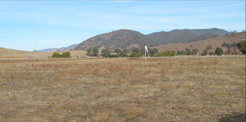
Tambo valley flood plain north of Swifts Creek
Original vegetation
Dry valley forest.
Soils
Component 1: Soils on flood plains
Most of the soils of this map unit occur on the flood plains. Generally they are dark greyish brown deep fine sandy to silty loams and clay loams, but layers of coarser material such and stones and gravel may occur deeper in the subsoil (Site EG201). Parts of the valley have been dredged for gold bringing the stones to the surface.
Component 2: Soils on the older alluvial terraces
Older alluvial terraces are a minor component of this map unit and where they do occur are above the level of the current flood plain. The surface soils are commonly very dark greyish brown loamy sands to sandy clay loams overlying brown or reddish brown subsoils with variable texture and structure. No pits have been dug on this component.
Component 3: Soils on the alluvial fans.
These are a very minor component of this map unit and would vary greatly in colour, texture and rock fragments.
Component 4: The stream channel.
Bed and bank erosion is common along the stream channels.
Site EG201
| Location: Swifts Creek | Geo. Ref. 0563288E 5877374N |
| Australian soil classification: Melanic, Eutrophic, Brown DERMOSOL | Dark brown uniform textured soil |
| General landscape description: Valley flat | |
| Geology: Recent alluvium | |
| Site description: Level | |
| Land use: Grazing on annual pasture | |
| Native vegetation: Dry valley forest | |
| Mapping unit: Walnut (Component 1) |
Soil Profile Morphology
| Surface soil | 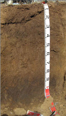 | ||
| A11 | 0 – 20 cm | Dark brown (10YR3/3); silty clay loam; strong fine (2 – 5 mm) granular structure; firm consistence dry; clear change to: | |
| A12 | 20 – 45 cm | Very dark greyish brown (10YR3/2); silty clay loam; strong fine (2 – 5 mm) granular structure; firm consistence dry; diffuse change to: | |
| A13 | 45 – 85 cm | Dark brown (10YR4/3); fine sandy clay loam; weak fine (2 – 5 mm) granular structure; firm consistence dry; clear change to: | |
| Deep subsoil (buried soil) | |||
| D | 85 – 105+ cm | Very dark grey (10YR3/1); clay loam; moderate medium (5 – 10 mm) polyhedral structure; firm dry | |
Key profile features
| |||
Soil profile characteristics
| pH | Salinity rating | Sodicity | Dispersion | Slaking | |
| Surface (A1 horizon) | Strongly acid | Very low | Non sodic | None | Water stable |
| Subsoil (A12 horizon) | Slightly acid | Very low | Non sodic | None | Slakes partially |
| Deeper subsoil (D horizon) | Slightly alkaline | Very low | Non sodic | None | Slakes considerably |
| Horizon | Depth cm | Field texture | pH water | pH CaCl2 | EC dS/m | Coarse sand % | Fine sand % | Silt % | Clay % | Field cap. % w/w | Wilt. point % w/w | PAW* water % w/w |
| A11 | 0-20 | ZCL | 5.5 | 4.9 | 0.12 | 5 | 42 | 26 | 19 | 35.4 | 10.9 | 24.5 |
| A12 | 20-45 | ZCL | 6.5 | 5.7 | 0.05 | 12 | 38 | 25 | 19 | 33.3 | 10.3 | 20.0 |
| A13 | 45-85 | FSCL | 7.2 | 6.4 | <0.05 | 8 | 46 | 24 | 18 | 30.4 | 9.1 | 21.3 |
| D | 85-105 | CL | 7.5 | 5.8 | 0.05 | 3 | 26 | 37 | 27 | 40.1 | 15.6 | 24.5 |
| Depth | Org C# | Total N | Free Fe2O3 % w/w | Exch. Al | Exchangeable cations meq/100 g | Ca:Mg | Na % | ||||||
| cm | % | % | ppm | Ca | Mg | K | Na | Total | H | CEC | |||
| 0-20 | 3.3 | 0.26 | <10 | 7.6 | 1.6 | 0.99 | 0.084 | 10.2 | 8.3 | 18.5 | 4.9 | <1 | |
| 20-45 | 2.1 | 0.12 | 9.3 | 1.9 | 0.29 | 0.14 | 11.6 | 4.4 | 16.0 | 4.9 | 1 | ||
| 45-85 | 0.95 | 9.2 | 2.7 | 0.18 | 0.22 | 12.3 | 12.3 | 3.4 | 2 | ||||
| 85-105 | 1.8 | 14 | 5.3 | 0.25 | 0.37 | 19.9 | 19.9 | 2.6 | 2 | ||||
Management considerations
Whole profile
- Plant available water capacity is considered to be low. This is based on an estimated effective rooting depth of 85 cm (i.e. the surface soil and the upper subsurface soil).
- The relatively deep surface soil is well structured.
- Infiltration of water into the well structured surface soil will be quite high. This horizon is also very well drained.
- The nutrient holding capacity of the surface (A1) horizon is moderate (based on the sum of the exchangeable cations). The organic matter for this soil is high which adds in both water and nutrient holding capacity.
- The upper subsurface soil is also well structured.
| Location: Swifts Creek | Geo. Ref. 0563300E 5877800N |
| Australian soil classification: Humose, Eutrophic, Brown DERMOSOL | Dark brown uniform textured soil |
| General landscape description: Valley flat | |
| Geology: Recent alluvium | |
| Site description: Level | |
| Land use: Grazing on annual pasture | |
| Native vegetation: Dry valley forest. Mostly Yellow Box, some Manna Gum | |
| Mapping unit: Walnut (Component 1) |
Soil Profile Morphology
| Surface soil | ||
| A0 | 0 – 7 cm | Loam; moderate crumb structure; abundant roots; abrupt wavy boundary to: |
| A11 | 4 – 11 cm | Dark brown (10YR3/3); fine sandy clay loam; apedal; slightly hard dry; abundant roots; abrupt wavy boundary to: |
| A12 | 11 – 44 cm | Very dark greyish brown (10YR3/2); fine sandy clay loam; apedal; common roots; clear wavy boundary to: |
| Subsoil | ||
| C1 | 44 – 87 cm | Dark brown to brown (10YR4/3); sand; apedal; 60 % fine gravel (3 mm); wavy boundary to: |
| C2 | 87 – 97 cm | Dark brown to brown (10YR4/3); sand; apedal; 60 % fine gravel (3 mm); wavy boundary to: |
| C3 | 97 – 107+ cm | Very dark brown (10YR3/2) with common distinct yellowish brown mottles; silty clay loam; apedal; soft consistence dry. |
Key profile feature
- Little colour or texture changes down the soil profile
| pH | Salinity rating | Sodicity | Dispersion | Slaking | |
| Surface (AO horizon) | Strongly acid | Low But harmless | Non sodic | ||
| Subsurface (A11 horizon) | Slightly acid | Very low | Non sodic | ||
| Deeper subsurface (A12 horizon) | Slightly alkaline | Very low | Non sodic |
| Horizon | Depth cm | Field texture | pH water | pH CaCl2 | EC dS/m | Coarse sand % | Fine sand % | Silt % | Clay % | Field cap. % w/w | Wilt. point % w/w | PAW* water % w/w |
| A0 | 0-7 | L | 5.4 | 0.38 | 0 | 26 | 16 | 17 | ||||
| A11 | 4-11 | FSL | 6.4 | 0.12 | 2 | 53 | 21 | 21 | ||||
| A12 | 11-44 | FSCL | 7.3 | 0.08 | 3 | 51 | 21 | 18 | ||||
| C1 | 44-87 | SL | 8.0 | 0.56 | 10 | 69 | 5 | 8 | ||||
| C2 | 87-97 | S | 10 |
| Depth | Org C# | Total N | Free Fe2O3 % w/w | Exch. Al | Exchangeable cations meq/100 g | Ca:Mg | Na % | ||||||
| cm | % | % | ppm | Ca | Mg | K | Na | Total | H | CEC | |||
| 0-7 | 22.0 | 1.74 | 0.9 | 14.7 | 4.7 | 2.1 | 0.1 | 21.6 | 38.8 | 60.4 | 3.1 | ||
| 4-11 | 2.7 | 0.23 | 1.5 | 9.4 | 2.4 | 1.6 | 0.1 | 13.5 | 8.0 | 21.5 | 3.9 | ||
| 11-44 | 1.0 | 0.10 | 1.5 | 7.8 | 2.3 | 1.0 | 0.1 | 11.2 | 4.6 | 15.8 | 3.4 | ||
| 44-87 | 1.4 | 3.9 | 1.0 | 1.0 | 0.1 | 6.0 | 2.3 | 7.3 | 3.9 | ||||
| 87-97 | |||||||||||||
© State of Victoria (Agriculture Victoria) 1996 - .

This work, Victorian Resources Online, is licensed under a Creative Commons Attribution 4.0 licence. You are free to re-use the work under that licence, on the condition that you credit the State of Victoria (Agriculture Victoria) as author, indicate if changes were made and comply with the other licence terms.
The licence does not apply to ‘branding’ or some ‘images or photographs’ that may be owned by third parties. We ask you to seek prior approval to use images using the VRO feedback form. Access to higher quality images can also be provided on request.
This page was last updated on .