
Omeo (Symbol: Om)
EG206 | EG55 | Profile No. 215 | EG71
Geology
Palaeozoic granite and associated metamorphic gniesses.
Landform
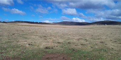
Enclosed low hills and valleys. Apart from the slopes adjoining the drainage lines, typical slope gradients are 8-20% with a relief of 30-90 m. The map unit may be subdivided into three components: crest and long gentle slopes, low lying open depressions and steep slopes adjoining drainage lines.
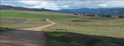
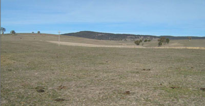
Cleared low hills on granite north of Lake Omeo
Original vegetation
Montane grassy woodland.
Soils
Component 1: Soils on crests and long gentle slopes
The majority of the soils of this unit are texture contrast soils with strongly acidic to moderately acidic surface soils. The surface soils are mostly brown to dark brown weakly structured sandy loams and overlie a bleached subsurface of similar texture. The subsoils, which occur about 30 to 60 cm, are brown to yellowish brown medium clays, often with paler coloured mottling. Rock generally occurs deeper than 1 m. (Sites EG 55, EG 206, Profile No. 215 (Rowe, 1967)). Very occasionally quartz stones occur which tend to accumulate in the surface soil just above the subsoil clay. These are believed to be due to lag deposits from narrow quartz rich dykes which can form in the granite rock.
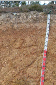
Quartz stones in the surface soil down-slope from a quartz rich dyke (left hand side of photo).
Component 2: Soils in low lying open depressions
The surface soils are generally very dark grey sandy loams to sandy clay loams overlying dark grey coarsely structured medium to heavy clays. (Site EG116).
Component 3: Soils on steep slopes adjoining drainage lines
On the steep slopes rock outcrops are common. No soil pits were excavated on this component.
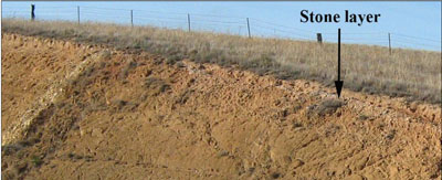
 Stone layer in cutting on Omeo – Swifts Creek road near Livingston Road | 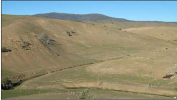 On steep slopes adjoining streams rock outcrops are common Land use All of the area is cleared and used for grazing. |
Site EG206
| Location: Omeo south | Geo. Ref. 0557479E 5887924N |
| Australian soil classification: Eutrophic, Mottled-Subnatric, Brown SODOSOL | Sodic brown texture contrast soil |
| General landscape description: Undulating low hills | |
| Geology: Palaeozoic granite | |
| Site Description: Convex lower slope, 2 % slope to North | |
| Land use: Grazing on annual pasture | |
| Native vegetation: Montane grassy woodland | |
| Mapping unit: Omeo (Component 1) |
Soil profile morphology
| Surface soil | 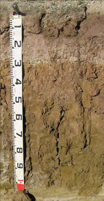 | ||
| A1 | 0 – 15 cm | Brown (7.5YR4/2); sandy loam; weak medium (10 – 20 mm) polyhedral structure; firm consistence dry; clear change to: | |
| A2 | 15 – 32 cm | Pale brown (10YR6/3) conspicuously bleached (10YR8/2d); sandy loam; apedal weak consistence dry; few (2 – 10 %) medium (2 – 6 mm) ferruginous concretions; sharp change to: | |
| Subsoil | |||
| B21 | 32 – 70 cm | Dark yellowish brown (10YR4/6) diffusely mottled with greyish brown (10YR5/2); medium clay; weak to moderate coarse (20 – 50 mm) prismatic structure; strong consistence dry; diffuse change to: | |
| B22 | 70 – 110+ cm | Brown (10YR4/3); medium clay; moderate coarse (20 – 50 mm) lenticular structure; strong consistence dry | |
Key profile features
| |||
Soil profile characteristics
| pH | Salinity rating | Sodicity | Dispersion | Slaking | |
| Surface soil (A1 horizon) | Strongly acid | Very low | Non sodic | Slight | Slakes partially |
| Subsoil (B21 horizon) | Slightly acid | Very low | Non sodic | None | Slakes considerably |
| Deeper subsoil (B22 horizon) | Slightly alkaline | Low | Sodic | None | Slakes considerably |
| Horizon | Depth cm | Field texture | pH water | pH CaCl2 | EC dS/m | Coarse sand % | Fine sand % | Silt % | Clay % | Field cap. % w/w | Wilt. point % w/w | PAW* water % w/w |
| A1 | 0-15 | SL | 5.3 | 4.6 | 0.07 | 22 | 36 | 28 | 7 | 23.3 | 5.2 | 18.1 |
| A2 | 15-32 | SL | 5.4 | 4.7 | <0.05 | 22 | 37 | 28 | 8 | 17.7 | 3.5 | 14.2 |
| B21 | 32-70 | MC | 6.5 | 5.7 | 0.14 | 15 | 15 | 12 | 54 | 31.0 | 18.8 | 12.2 |
| B22 | 70-110 | MC | 7.3 | 6.6 | 0.31 | 6 | 12 | 20 | 60 | 38.8 | 22.2 | 16.6 |
| Depth | Org C# | Total N | Free Fe2O3 % w/w | Exch. Al | Exchangeable cations meq/100 g | Ca:Mg | Na % | ||||||
| cm | % | % | ppm | Ca | Mg | K | Na | Total | H | CEC | |||
| 0-15 | 2.1 | 0.15 | <10 | 2.7 | 0.56 | 0.16 | 0.12 | 3.5 | 5.6 | 9.1 | 4.8 | 1 | |
| 15-32 | 0.59 | <0.05 | <10 | 1.4 | 0.36 | <0.05 | 0.11 | 1.9 | 2.1 | 4.0 | 3.8 | 3 | |
| 32-70 | 0.55 | 6.3 | 7.4 | 0.26 | 1.3 | 15 | 5.8 | 20.8 | 0.8 | 6 | |||
| 70-110 | 0.38 | ||||||||||||
Management considerations
Whole profile
- The soil shows marked texture contrast between the surface soil and the subsoil.
- Plant available water content is quite low based on a root depth of 45 cm. The dense and coarsely structured subsoil is likely to restrict root growth and confine most of the roots to the surface soil.
- The low wilting points (5.2 and 3.5 %) of the surface soils indicates the plants are able to utilize very light rains when the soil is dry. However, due to the low water storage capacity, plants will soon suffer moisture stress unless further rains occur.
- The surface soils are strongly acid. However the level of exchangeable aluminium is reasonably low 16 mg/kg) and is unlikely to affect the growth of aluminium sensitive species, except the most sensitive. Lime can be used to increase soil pH but a pH/aluminium test is best performed by taking samples across the paddock and bulked together. The use of test strips to observe lime response could be used as an aid in evaluating its cost/benefit. For this soil a response to lime (about 1-2 tonnes/ha) would be expected.
- The organic matter content of the soil is moderate. Such levels result in a moderate structural condition and moderate structural stability. Careful pasture management is needed to maintain organic matter levels.
- Potassium is too low for pastures and a response to potassium fertilisers would be anticipated.
- Salinity is not a problem in the surface soil.
- The nutrient holding capacity of the surface (A1 and A2) horizons is very low (based on the sum of the exchangeable calcium, magnesium, potassium and sodium cations).
- The bleached subsurface layer lacks structure, sets hard when dry, impedes plant growth and slakes when wet.
- The coarsely structured and high clay subsoil is sodic with a low calcium to magnesium ratio of 0.8. Water and root movement in the subsoil will be restricted by these conditions.
- Root and water movement is likely to be restricted in the dense and coarsely structured subsoil. Mottled colours indicate the subsoil is imperfectly drained in wet periods.
- This soil is highly prone to water erosion.
- The roots tend to follow cracks between the soil aggregates and can only extract part of the soil water.
- Salinity in the deep subsoil (70 cm) is higher than normal and may restrict the growth of deep rooted species.
| Location: Upper Livingston Road | Geo. Ref. 0548363E 5884687N |
| Australian soil classification: Bleached, Eutrophic, Yellow CHROMOSOL | Yellow texture contrast soil |
| General landscape description: Rolling low hills | |
| Geology: Ordovician metamorphosed sediments (gneiss) | |
| Site Description: Lower slope (unspecified gradient) | |
| Land use: Grazing on annual pasture | |
| Native vegetation: Montane grassy woodland | |
| Mapping unit: Omeo (Component 1) |
Soil profile morphology
| Surface soil | 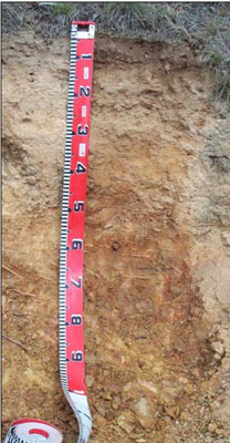 | ||
| A1 | 0 – 10 cm | Dark brown (7.5YR3/2); sandy loam; weak polyhedral structure; clear change to: | |
| A21 | 10 – 25 cm | Yellowish brown (10YR5/4) conspicuously bleached dry; loamy sand; massive; gradual change to: | |
| A22 | 25 – 45 cm | Light yellowish brown (2.5YR6/4) conspicuously bleached dry; coarse sandy loam; massive; common (10 – 20%) fine gravel (2 – 6 mm); clear change to: | |
| Subsoil | |||
| B2 | 45 – 85 cm | Yellowish brown (10YR5/4); medium clay; strong coarse prismatic structure parting to angular blocky structure; slight (2 – 10%) fine gravel (2 – 6 mm), with increasing amounts of angular tabular pebbles (20 – 60 mm) becoming larger in size with depth; clear change to: | |
| C | 85 cm+ | Decomposing rock |
Soil profile characteristics
| pH | Salinity rating | Sodicity | Dispersion | Slaking | |
| Surface soil (A1 horizon) | Strongly acid | Very low | Non sodic | Slight | Water stable |
| Subsurface (A22 horizon) | Moderately acid | Very low | Non sodic | Strong | Slakes partially |
| Deeper subsoil (B2 Horizon) | Moderately acid | Very low | Non sodic | Strong | Slakes partially |
| Horizon | Depth cm | Field texture | pH water | pH CaCl2 | EC dS/m | Coarse sand % | Fine sand % | Silt % | Clay % | Field cap. % w/w | Wilt. point % w/w | PAW* water % w/w |
| A1 | 0-10 | SL | 5.5 | 4.8 | 0.11 | 33 | 35 | 16 | 11 | 20.5 | 7.5 | 13.0 |
| A21 | 10-25 | LS | 5.8 | 5.1 | 0.06 | 40 | 36 | 15 | 10 | 14.6 | 3.6 | 11.0 |
| A22 | 25-45 | KSL | 5.8 | 5 | 0.05 | 35 | 33 | 13 | 19 | 15.2 | 6.5 | 8.7 |
| B2 | 45-85 | MC | 6.0 | 5.1 | 0.07 | 20 | 19 | 12 | 50 | 30.7 | 17.3 | 13.4 |
| Depth | Org C# | Total N | Free Fe2O3 % w/w | Exch. Al | Exchangeable cations meq/100 g | Ca:Mg | Na % | ||||||
| cm | % | % | ppm | Ca | Mg | K | Na | Total | H | CEC | |||
| 0-10 | 4.0 | 0.2 | <10 | 2.9 | 1.6 | 0.71 | 0.11 | 5.4 | 9.1 | 14.5 | 1.9 | 1 | |
| 10-25 | <10 | 1.0 | 0.69 | 0.39 | 0.06 | 2.2 | 3.4 | 5.6 | 1.5 | 1 | |||
| 25-45 | 15 | 0.98 | 1.6 | 0.35 | 0.09 | 3.1 | 3.7 | 6.8 | 0.7 | 1 | |||
| 45-85 | 15 | 2.0 | 5.0 | 0.87 | 0.25 | 8.2 | 7.7 | 15.9 | 0.4 | 2 | |||
Management considerations
Whole profile
- The soil shows marked texture contrast between the surface soil and the subsoil.
- Plant available water content is considered to be low, based on a root depth of 55 cm. The massive and hard setting nature of the subsurface soils (A21 and A22) and the dense and coarsely structured subsoil is likely to restrict root growth and confine most of the roots to the surface soil.
- The low wilting points (7.5 and 3.6 %) of the surface soils indicates the plants are able to utilize very light rains when the soil is dry. However, due to the low water storage capacity, plants will soon suffer moisture stress unless further rains occur.
- The surface soils are strongly acid. However the level of exchangeable aluminium is low (less than 10 mg/kg) and is unlikely to affect the growth of aluminium sensitive species, except the most sensitive. Here the subsurface soil is moderately acidic and a response to lime may not occur.
- The organic matter content of the soil is high. Such levels result in a high structural condition and high structural stability. Careful pasture management is needed to maintain organic matter levels, particularly in these soils as they have a hard setting subsurface soil.
- Potassium is high for pastures and no response to potassium fertilisers would be anticipated.
- Salinity is not a problem in the surface soil.
- The nutrient holding capacity of the surface (A1 and A2) horizons is low (based on the sum of the exchangeable calcium, magnesium, potassium and sodium cations).
- The bleached subsurface layer lacks structure, sets hard when dry, impedes plant growth and slakes when wet.
- The coarsely structured and high clay subsoil is non-sodic but has a low calcium to magnesium ratio of 0.4. Water and root movement in the subsoil will be restricted by these conditions. Little can be done to overcome these soil properties.
- Root and water movement is likely to be restricted by the dense and coarsely structured subsoil.
- This soil is highly prone to water erosion.
| Location: Bald Hills Road Omeo south | No Geo. Ref. available |
| Australian soil classification: Eutrophic, Subnatric, Yellow SODOSOL | Sodic yellow texture contrast soil |
| General landscape description: Undulating low hills | |
| Geology: Palaeozoic granite | |
| Site Description: None given | |
| Land use: Grazing on annual pasture | |
| Native vegetation: Montane grassy woodland | |
| Mapping unit: Omeo (Component 1) |
No photo available
Soil profile morphology
Not available, but observations of shallow road exposures along Bald Hills Road show surface soils overlying bleached subsurface soils with yellow brown clay subsoils.
Soil profile characteristics
| Horizon | Depth cm | Field texture | pH water | pH CaCl2 | EC dS/m | Coarse sand % | Fine sand % | Silt % | Clay % | Field cap. % w/w | Wilt. Point % w/w | PAW* water % w/w |
| A1 | 0-8 | L | 5.6 | 0.05 | 27 | 26 | 24 | 20 | ||||
| A2 | 15-30 | LS | 6.0 | <0.05 | 39 | 36 | 16 | 7 | ||||
| B21 | 30-60 | C | 6.5 | 0.08 | 16 | 15 | 7 | 61 | ||||
| B22 | 90-120 | C | 8.4 | 0.16 | 41 | 31 | 12 | 17 |
| Depth | Org C# | Total N | Free Fe2O3 % w/w | Exch. Al | Exchangeable cations meq/100 g | Ca:Mg | Na % | ||||||
| cm | % | % | ppm | Ca | Mg | K | Na | Total | H | CEC | |||
| 0-8 | 1.7 | 0.15 | 1.0 | 4.6 | 1.7 | 0.4 | 0.1 | 6.8 | 7.4 | 14.2 | 2.7 | 1 | |
| 15-30 | 0.2 | 0.02 | 0.8 | 1.3 | 0.6 | 0.1 | 0.05 | 2.1 | 2.9 | 5.0 | 2.2 | 1 | |
| 30-60 | 2.9 | 3.7 | 12.4 | 0.3 | 1.9 | 18.3 | 20.5 | 28.8 | 0.3 | 7 | |||
| 90-120 | 1.8 | 3.3 | 9.5 | 1.9 | 2.8 | 15.7 | - | 15.4 | 0.4 | 18 | |||
Management considerations
Surface (A) horizons
- The soils are moderately acid but may show a slight response to lime applications.
- The potassium levels are moderate and no response to potassium fertilisers would be expected.
- Salinity is not a problem in the surface soil.
- The nutrient holding capacity of the surface (A1 and A2) horizons is low to very low (based on the sum of the exchangeable calcium, magnesium, potassium and sodium cations).
- The coarsely structured and high clay subsoil is sodic with very low calcium to magnesium ratio of 0.3. Water and root movement in the subsoil will be restricted by these conditions.
- This soil is highly prone to water erosion.
| Location: Omeo, Barbers Lane | Geo. Ref. 0555912E 5892285N |
| Australian soil classification: Yellow SODOSOL | Sodic yellow texture contrast soil |
| General landscape description: Undulating low hills | |
| Geology: Palaeozoic granite | |
| Site Description: Hill-slope, gradient unspecified | |
| Land use: Grazing on annual pasture | |
| Native vegetation: Grassy woodland | |
| Mapping unit: Omeo (Component 1) |
Soil profile morphology
| Surface soil | 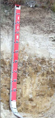 | ||
| A1 | 0 – 25/30 cm | Very dark greyish brown (10YR3/2); sandy loam (light and high in organic matter); weak polyhedral structure; common (10 – 20%) fine (2 – 6 mm) gravel; clear wavy change to: | |
| A2 | 25/30 – 50/55 cm | Very pale brown (10YR7/3) conspicuously bleached (10YR8/2d); loamy sand; massive; strong consistence dry; slight (2 – 10%) fine (2 – 6 mm) gravel; clear wavy change to: | |
| Subsoil | |||
| B21 | 50/55 – 100 cm | Yellowish brown (10YR5/4); medium heavy clay; coarse prismatic structure parting to angular blocky structure; strong consistence dry; slight (2 – 10%) fine (2 – 6 mm) gravel. |
© State of Victoria (Agriculture Victoria) 1996 - .

This work, Victorian Resources Online, is licensed under a Creative Commons Attribution 4.0 licence. You are free to re-use the work under that licence, on the condition that you credit the State of Victoria (Agriculture Victoria) as author, indicate if changes were made and comply with the other licence terms.
The licence does not apply to ‘branding’ or some ‘images or photographs’ that may be owned by third parties. We ask you to seek prior approval to use images using the VRO feedback form. Access to higher quality images can also be provided on request.
This page was last updated on .