
Hinnomunjie (Symbol: He)
EG51 | EG205 | EG60
Geology
Ordovician metamorphosed sediments, mainly schists and phyllites; deeply weathered and associated colluvium.
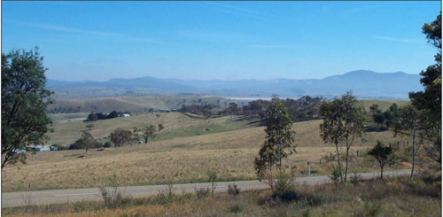
Landform
Rolling low hills. Elevation range 600 – 800 m with local relief 30 – 90 m, and typical slope gradients 8 – 20 %. Broad concave drainage lines with slope gradients up to 5 %.
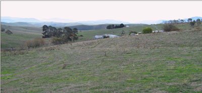
The Hinnomunjie map unit may be subdivided into three components: Moderate to gentle slopes on hard rock are the most extensive component, crests and upper slopes, and open depressions.
Original vegetation
Montane dry woodland
Soils
Component 1: Crest and upper slopes
The soils on the crests and upper slopes are likely to be shallower and have a less pronounced B horizon than that down-slope. No soils were examined in detail on this component but a soil exposure is given (EG51).
Component 2: Soils on moderate to gentle slopes
Most of the soils on this map unit are texture contrast soils, which mean they have light textured surface soils abruptly overlying clay subsoil. The surface soils are dark brown to reddish brown fine sandy loams to fine sandy clay loams, sub-surfaces occasionally bleached; abruptly overlying reddish brown to red clay subsoils at about 25 to 50 cm. Decomposing rock generally occurs between 0.6 and 1.0 m. Surface soils range in pH from strongly acidic to moderately acidic, have moderate organic matter and a moderate water and nutrient holding capacity. The strongly structured subsoil clays are well drained with pHs ranging from moderately acid to slightly acid. Although the subsoils do not disperse, many tend to slake considerably when wet. Gully erosion may occur where water is channelled, for example along road reserves and in open depressions. (See EG205, EG51 and EG60).
Component 3: Soils in open depressions
No soils were examined on this component but it would be anticipated the depth of soil would be deeper towards the bottom of the slope and thus deepest in the foot slopes and open depressions. Deep gullies have formed in many of the open depressions, particularly when the slope exceeds 5%.
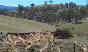
Gully erosion often occurs in the open depressions of the Hinnomunjie map unit
Site EG51
| Location: Hinnomunjie | 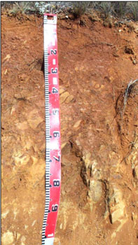 The soils on the crests and upper slopes generally have rock close to the surface. No landscape photo taken |
| Australian soil classification: Red DERMOSOL (stony) | |
| Geo. Ref. 0557873E 5902582N | |
| Shallow red gradational soil | |
| General landscape description: Rolling low hills | |
| Geology: Ordovician metamorphosed sediments | |
| Site Description: Upper slope, gradient unspecified | |
| Land use: Grazing on annual pasture | |
| Native vegetation: Montane dry woodland | |
| Mapping unit: Hinnomunjie (Crests and upper slopes, Component 1) | |
| Physical and chemical data: No physical or chemical data were determined for this site. |
Site EG205
| Location: Hinnomunjie | Geo. Ref. 0557480E 5901636N |
| Australian soil classification: Eutrophic, Brown CHROMOSOL | Red-brown texture contrast soil |
| General landscape description: Rolling low hills | |
| Geology: Ordovician metamorphosed sediments | |
| Site Description: Lower north-west facing slope (8% slope) | |
| Land use: Grazing on annual pasture | |
| Original vegetation: Montane dry woodland | |
| Mapping unit: Hinnomunjie (Component 2) |
Soil profile morphology
| Surface soil | 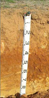 | ||
| A11 | 0 – 15 cm | Reddish brown (5YR4/3); clay loam; weak medium (10 – 20 mm) polyhedral structure; weak consistence dry; clear change to: | |
| A12 | 15 – 25 cm | Reddish brown (5YR5/4); clay loam; weak medium (10 – 20 mm) polyhedral structure; weak consistence dry; many (20 – 50%) angular tabular (20 – 60 mm) pebbles; clear change to: | |
| A13 | 25 – 30 cm | Red (2.5YR4/6); clay loam; strong fine (2 – 5 mm) granular structure; firm consistence dry; many (20 – 50%) angular tabular (20 – 60 mm) pebbles; diffuse change to: | |
| Subsoil | |||
| B1 | 30 – 40 cm | Red (2.5YR4/6); light medium clay; strong fine (2 – 5 mm) granular structure; firm consistence dry; clear change to: | |
| B21 | 40 – 65 cm | Reddish brown (7.5YR4/4); medium clay; strong fine (2 – 5 mm) granular structure; firm consistence dry; clear change to: | |
| C | 65 – 85 cm | Brown (7.5YR4/4); medium clay with soft rock; common (10 – 20 %) angular tabular (6 – 20 mm) pebbles; soft rock increasing with depth. |
Key profile features
- Gradual increase in soil texture down the soil profile.
| pH | Salinity rating | Sodicity | Dispersion | Slaking | |
| Surface soil (A1 horizon) | Strongly acid | Very low | Non sodic | None | Water stable |
| Subsoil (B21 horizon) | Moderately acid | Very low | Non sodic | None | Slakes considerably |
| Deep subsoil (B22 horizon) | Slightly acid | Very low | Non sodic | None | Slakes considerably |
| Horizon | Depth cm | Field texture | pH water | pH CaCl2 | EC dS/m | Coarse sand % | Fine sand % | Silt % | Clay % | Field cap. % w/w | Wilt. point % w/w | PAW* water % w/w |
| A11 | 0-15 | CL | 5.2 | 4.7 | 0.13 | 16 | 51 | 10 | 16 | 19.7 | 6.1 | 13.6 |
| A12 | 15-25 | CL | 5.2 | 4.6 | 0.07 | 18 | 52 | 8 | 18 | 18.3 | 5.4 | 12.9 |
| A13 | 25-30 | CL | 5.6 | 4.9 | <0.05 | 18 | 49 | 12 | 17 | 19.6 | 6.6 | 13.0 |
| B21 | 30-40 | LMC | 6.0 | 5.2 | <0.05 | 7 | 46 | 13 | 31 | 24.5 | 11.4 | 13.1 |
| B22 | 40-65 | MC | 6.5 | 5.6 | <0.05 | 2 | 16 | 9 | 70 | 37.9 | 24.7 | 13.2 |
| Depth | Org C# | Total N | Free Fe2O3 % w/w | Exch. Al | Exchangeable cations meq/100 g | Ca:Mg | Na % | ||||||
| cm | % | % | ppm | Ca | Mg | K | Na | Total | H | CEC | |||
| 0-15 | 2.5 | 0.19 | 3.4 | 12 | 3 | 1 | 0.5 | 0.07 | 4.6 | 5.7 | 10.3 | 3.0 | <1 |
| 15-25 | 1.2 | 0.09 | 18 | 2.3 | 0.83 | 0.22 | 0.08 | 3.4 | 5.1 | 8.5 | 2.8 | <1 | |
| 25-30 | 0.84 | 11 | 2.5 | 1.5 | 0.22 | 0.09 | 4.4 | 4.7 | 9.1 | 1.7 | <1 | ||
| 30-40 | 0.68 | <10 | 3.3 | 3.8 | 0.25 | 0.16 | 7.5 | 6.2 | 13.7 | 0.9 | 1 | ||
| 40-65 | 0.7 | N/A | 5.3 | 9 | 0.37 | 0.28 | 15 | 11.0 | 26.0 | 0.6 | 1 | ||
Management considerations
Whole profile
- Infiltration of water though the upper part of the soil profile will be rapid due to porous nature of the surface horizons.
- Plant available water content for this profile is considered to be moderate, based on a plant root depth of 65 cm.
- The clay content increases quite markedly at 40 cm.
- The low wilting point (6.1, 5.4 and 6.6) of the surface soils indicates the plants are able to utilise very light rains when the soil is dry. However, due to the low water storage capacity, plants will soon suffer moisture stress unless further rains occur.
- The organic matter content of the soil is high. Such levels result in a good structural condition and good structural stability.
- The surface soil is strongly acid and a pasture response to lime additions would be quite likely. As the soil is also fairly high in iron oxide, deficiencies in phosphorus and molybdenum are likely and lime applications would increase nutrient availability.
- Potassium at a moderate level for pastures and no response to potassium fertiliser would be expected.
- Salinity is not a problem in the surface soil.
- The nutrient holding capacity of the surface horizons is low (based on the sum of the exchangeable calcium, magnesium, potassium and sodium cations). Organic matter is important for maintaining soil fertility on such soils.
- The subsoil and the deep subsoil are not sodic and do not disperse. However both slake considerably and if the subsoil is exposed, for example by a gully head, headward erosion is very highly likely.
| Location: Hinnomunjie | Geo. Ref. 0556013E 5908785N |
| Australian soil classification: Eutrophic, Brown CHROMOSOL | Brown texture contrast soil |
| General landscape description: Rolling low hills | |
| Geology: Ordovician metamorphosed sediments | |
| Site Description: Mid-slope (slope not specified) | |
| Land use: Grazing on annual pasture | |
| Native vegetation: Montane dry woodland | |
| Mapping unit: Hinnomunjie (Component 2) |
Soil profile morphology
| Surface soil | 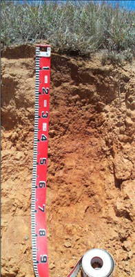 | ||
| A1 | 0 – 10 cm | Dark brown (7.5YR3/2); fine sandy loam; weak polyhedral structure; gradual change to: | |
| A2 | 10 – 25 cm | Yellowish brown (10YR5/4) conspicuously bleached (10YR7/3); fine sandy clay loam; apedal; clear change to: | |
| Subsoil | |||
| B2 | 25 – 85 cm | Brown (7.5YR5/4) mottled with reddish brown (5YR5/4); medium clay; strong angular blocky structure; strong consistence dry; slight amounts (2 – 10%) large pebbles (20 – 60 mm) overlying decomposing rock. | |
Key profile features
| |||
Soil profile characteristics
| pH | Salinity rating | Sodicity | Dispersion | Slaking | |
| Surface soil (A1 horizon) | Strongly acid | Very low | Non sodic | None | Water stable |
| Subsurface soil (A2 horizon) | Moderately acid | Very low | Non sodic | None | Water stable |
| Subsoil (B2 horizon) | Moderately acid | Very low | Non sodic | none | Water stable |
| Horizon | Depth cm | Field texture | pH water | EC dS/m | Coarse sand % | Fine sand % | Silt % | Clay % | Field cap. % w/w | Wilt. point % w/w | PAW* water % w/w | Free Fe2O3 % w/w |
| A1 | 0-10 | FSL | 5.5 | 0.07 | 7 | 53 | 19 | 16 | 31.5 | 10.0 | 21.5 | |
| A2 | 10-25 | FSCL | 5.6 | 0.06 | 9 | 54 | 17 | 21 | 28.4 | 7.6 | 20.8 | |
| B2 | 25-80 | MC | 5.6 | 0.06 | 1 | 28 | 11 | 60 | 41.1 | 21.1 | 20.0 |
| Depth | Org C# | Total N | Exch. Al | Exchangeable cations meq/100 g | Ca:Mg | Na % | ||||||
| cm | % | % | ppm | Ca | Mg | K | Na | Total | H | CEC | ||
| 0-10 | 2.5 | 0.2 | <10 | 3.0 | 1.9 | 0.4 | 0.07 | 5.4 | 8.2 | 13.6 | 1.6 | 1 |
| 10-25 | 15 | 2.2 | 2.1 | 0.23 | 0.07 | 4.6 | 6.0 | 10.6 | 1.1 | 1 | ||
| 25-80 | 74 | 3.0 | 7.1 | 0.25 | 0.32 | 11.0 | 13.0 | 24.0 | 0.5 | 1 | ||
Management considerations
Whole profile
- Infiltration of water though the upper part of the soil profile will be rapid due to the porous nature of the surface horizons.
- Plant available water content for this profile is considered to be moderate, based on a plant root depth of 65 cm.
- The clay content increases quite markedly at 25 cm.
- The low wilting point (10.0 and 7.6) of the surface soils indicates the plants are able to utilize very light rains when the soil is dry. However, due to the low water storage capacity, plants will soon suffer moisture stress unless further rains occur.
- The organic matter content of the soil is high. Such levels result in a good structural condition and good structural stability.
- The surface soil is moderately to strongly acid so a pasture response to lime would be likely. Deficiencies in phosphorus and molybdenum are also likely and lime applications would increase the availability of these nutrients.
- Potassium is bordering on deficient for pastures and a response to potassium fertiliser would be expected under rapid growing conditions
- Salinity is not a problem in the surface soil.
- The nutrient holding capacity of the surface horizons is low (based on the sum of the exchangeable calcium, magnesium, potassium and sodium cations). Organic matter is important for maintaining soil fertility on such soils.
- The subsoil and the deep subsoil are not sodic and do not disperse.
© State of Victoria (Agriculture Victoria) 1996 - .

This work, Victorian Resources Online, is licensed under a Creative Commons Attribution 4.0 licence. You are free to re-use the work under that licence, on the condition that you credit the State of Victoria (Agriculture Victoria) as author, indicate if changes were made and comply with the other licence terms.
The licence does not apply to ‘branding’ or some ‘images or photographs’ that may be owned by third parties. We ask you to seek prior approval to use images using the VRO feedback form. Access to higher quality images can also be provided on request.
This page was last updated on .