
Fraser (Symbol: Fr)
EG113
Geology
This unit comprises Tertiary basalt and associated colluvium. About 2.3 million years ago a basalt flow blocked the early course of Morass Creek. This basalt flow is referred to as the Deep Creek basalt as it is believed to have originated in the valley of that tributary of Morass Creek. The basalt extends from Uplands in the south to the junction of the Gibbo River and Morass Creek in the north. Remnants of the flow extend up the Gibbo River. These streams cut a new course flanking the basalt flow, leaving the basalt flow as a plateau.
Landform
Enclosed rises and plateaux. Elevation range 620 – 720 m with local relief up to 9-30 m, and typical slope gradients <3 %.
The Fraser map unit may be subdivided into two components: the most extensive being the plateau (level to rolling plains standing above a scarp extending around a large part of the perimeter) and the adjacent scarp. Hills above the level of the plateaux are mapped into the adjoining unit.
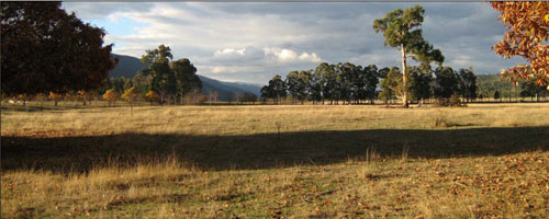
Fraser map unit: basalt plateaux near the junction of Morass Creek and Gibbo River
| Soils Component 1: Soils on the plateau These are deep red and brown clay loam soils formed on basalt. The typical soils are mostly dark reddish brown clay loams overlying reddish brown clay loams to medium clays. Dark brown soils may also be present. Basalt cobbles and stones may occur within the soil profile. Surface soils may be weakly structured to strongly structured, but the subsoil is generally strongly structured (i.e. very friable). Judging by road cuttings the depth to basalt rock is about 1.0 – 2.0 m. Mostly the land is used for grazing, but some walnuts are grown. Component 2: Soils on the adjacent scarp The western flank of the Fraser Tableland mostly has soils on granite, but some basalt colluvium and basalt boulders may be also present. No pits were excavated on the scarp.
Soils on the adjacent hills | 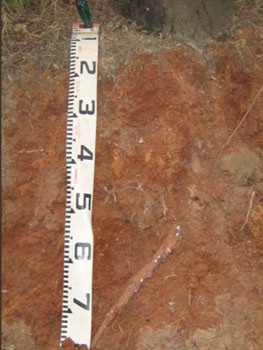 |
Site EG113
| Location: Tablelands road | Geo. Ref. 0562503E 5920654N |
| Australian soil classification: Eutrophic, Brown, FERROSOL (stony) | Brown gradational soil |
| General landscape description: Plateau | |
| Geology: Tertiary (Neogene) basalt | |
| Site Description: 2 – 5% slope | |
| Land use: Grazing on annual pasture | |
| Original vegetation: Grassy woodland | |
| Mapping unit: Fraser (Component 1) |
Soil profile morphology
| Surface soil | 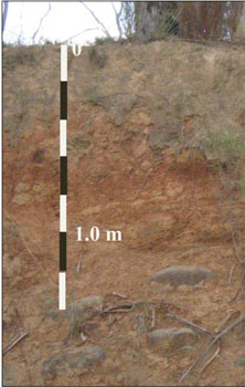 | ||
| A11 | 0 – 5 cm | Dark reddish brown (5YR3/2); clay loam; weak fine polyhedral structure; weak consistence dry; clear change to: | |
| A12 | 5 – 30 cm | Reddish brown (5YR4/3); clay loam; moderate fine polyhedral structure; firm consistence dry; few (2 – 10%) medium rounded (6 – 20 mm) pebbles; gradual change to: | |
| Subsoil | |||
| B21 | 30 – 60 cm | Dark reddish brown (2.5YR3/3); medium clay; strong medium polyhedral structure; very firm consistence dry; basalt pebbles increasing and becoming larger with depth; gradual change to: | |
| R | 60 cm - 1m+ | Decomposing basalt rock |
Key profile features
- Gradual increase in texture down the soil profile.
Soil profile characteristics
| pH | Salinity rating | Sodicity | Dispersion | Slaking | |
| Surface soil (A12 horizon) | Slightly acid | Very low | Non sodic | None | Water stable |
| Subsoil (B2 horizon) | Slightly acid | Very low | Non sodic | None | Water stable |
| Horizon | Depth cm | Field texture | pH water | pH CaCl2 | EC dS/m | Coarse sand % | Fine sand % | Silt % | Clay % | Field cap. % w/w | Wilt. point % w/w | PAW* water % w/w |
| A12 | 5-30 | CL | 6.2 | 5.5 | 0.07 | 13 | 34 | 32 | 22 | 17.5 | 4.4 | 13.1 |
| B21 | 30-60 | MC | 6.4 | 5.6 | 0.06 | 5 | 23 | 27 | 43 | 28.4 | 10.3 | 18.1 |
| Depth | OrgC# | Total N | Free Fe2O3 % w/w | Exch. Al | Exchangeable cations meq/100 g | Ca:Mg | Na % | ||||||
| cm | % | % | ppm | Ca | Mg | K | Na | Total | H | CEC | |||
| 5-30 | 2.7 | 3.4 | <10 | 5.7 | 3.2 | 1.2 | <0.05 | 10 | 17.8 | 1.8 | <1 | ||
| 30-60 | 5.1 | <10 | 9.3 | 7.0 | 1.5 | 0.07 | 18 | 29 | 1.4 | <1 | |||
Management considerations
Whole Profile
- The profile is slightly acid throughout.
- These soils are very well drained due to their strongly developed subsoil structure.
- Plant available water is considered to be moderate, based on the laboratory data and the effective rooting depth of 70 cm.
- The soil has moderate organic matter content. Organic matter will be better maintained under rotational grazing, which enables stronger pasture recovery, rather than set stocking.
- The nutrient holding capacity of the soil is moderate (based on the sum of the exchangeable cations). Organic matter is also important for maintaining soil fertility.
- Although the soils are fairly high in iron oxide (3.4%), the pH is high enough to minimise phosphorus fixation.
- The friable nature of the subsoil allows deep penetration of plant roots.
- The friable nature of the subsoil together with the shallow depth to rock, can lead to problems with sealing of earth dams.
© State of Victoria (Agriculture Victoria) 1996 - .

This work, Victorian Resources Online, is licensed under a Creative Commons Attribution 4.0 licence. You are free to re-use the work under that licence, on the condition that you credit the State of Victoria (Agriculture Victoria) as author, indicate if changes were made and comply with the other licence terms.
The licence does not apply to ‘branding’ or some ‘images or photographs’ that may be owned by third parties. We ask you to seek prior approval to use images using the VRO feedback form. Access to higher quality images can also be provided on request.
This page was last updated on .