
Combienbar (Symbol: Cm)
EG218
Geology
Late Devonian alluvial sediments (conglomerate, sandstone, mudstone) often referred to as the ‘red beds’.
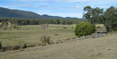
Landform
Rolling low hills. The Combienbar map unit occupies the lower valley slopes, generally less than 32%. The adjacent steeper land is mapped into the Turton map unit. The narrow valley floors are delineated on the map as river flats (symbol: rf).
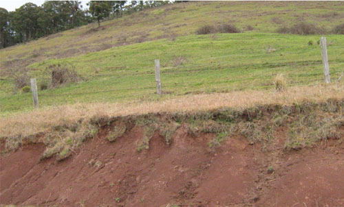
Road cutting near Buldah
Native vegetation
Damp forest and lowland forest. Riparian forest occurs in the valley floors.
Soils
All the surface soils examined are strongly to moderately acid, weakly structured and hard-setting, fine sandy and silty loams with a medium to low nutrient and water holding capacity. Decomposing rock occurs at a variable depth, generally before 1 m, becoming shallower with increasing slope. Any cultivation is best carried out before the soil dries out as it will become ‘powdery’ and hard setting if dry.
Land use
The cleared land is used for grazing.
Site EG218
| Location: Combienbar | Geo. Ref. 0678100E 5860100N |
| Australian Soil Classification: Bleached-Mottled, Magnesic, Grey DERMOSOL | Grey gradational soil |
| General landscape description: Rolling low hills | |
| Geology: Late Devonian fluvial sediments (conglomerate, sandstone, mudstone) | |
| Site description: Upper simple slope, 8% slope, east aspect | |
| Land use: Grazing | |
| Native vegetation: Damp forest and lowland forest | |
| Mapping unit: Combienbar |
Soil profile morphology
| Surface soil | 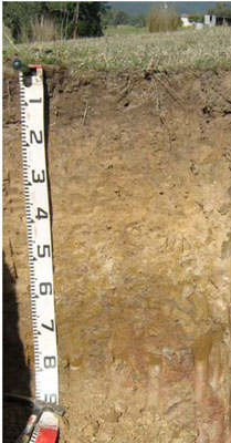 | ||
A1 | 0 – 15 cm | Very dark greyish brown (10YR3/2); very fine sandy loam; weak granular structure; very weak consistence, moist; pH 5.2; clear change to: | |
A2 | 15 – 40 cm | Light brownish grey (10YR6/2) conspicuously bleached with brownish yellow (10YR6/6) mottling increasing with depth; silty loam; apedal; very weak granular structure; weak consistence moist; pH 5.3; sharp change to: | |
Subsoil | |||
B1 | 40 – 60 cm | Greyish brown (10YR5/2) with few medium distinct brown (7.5YR4/4) mottles; silty clay; moderate medium polyhedral structure; very firm consistence moist; pH 5.7; clear change to: | |
B2 | 60 – 90 cm | Greyish brown (10YR5/2) with many coarse distinct reddish brown (5YR4/4) mottles; medium to heavy clay; weak medium polyhedral structure; firm consistence moist; pH 5.6; clear change to: | |
C | 90+ cm | Decomposing rock. | |
Key profile features
| |||
| pH | Salinity rating | Sodicity | Dispersion | Slaking | |
| Surface soil (A1 horizon) | Strongly acid | Very low | Non sodic | None | Slakes partially |
| Subsoil (B1 horizon) | Moderately acid | Very low | Non sodic | Moderate1 | Slakes considerably |
| Deeper subsoil (60-90 cm) | Moderately acid | Very low | Non sodic | Slight1 | Slakes considerably |
| Horizon | Depth cm | Field texture | pH water | pH CaCl2 | EC dS/m | Coarse sand % | Fine sand % | Silt % | Clay % | Field cap. % w/w | Wilt. point % w/w | PAW* water % w/w |
| A1 | 0-15 | VFSL | 5.2 | 4.2 | <0.05 | 2 | 54 | 20 | 16 | 28.0 | 6.0 | 22.0 |
| A2 | 15-40 | ZL | 5.3 | 4.1 | <0.05 | 2 | 53 | 20 | 20 | 23.1 | 5.4 | 17.7 |
| B1 | 40-60 | ZC | 5.7 | 3.9 | <0.05 | 1 | 39 | 24 | 32 | 28.3 | 13.6 | 14.7 |
| B2 | 60-90 | MHC | 5.6 | 3.9 | <0.05 | 0 | 14 | 25 | 57 | 39.5 | 23.5 | 16.0 |
| Depth | OrgC# | Total N | Free Fe2O3 | Exch. Al | Exchangeable cations meq/100 g | Ca:Mg | ESP | ||||||
| cm | % | % | % w/w | ppm | Ca | Mg | K | Na | Total | H | CEC | ||
| 0-15 | 2.6 | 0.14 | 87 | 1.5 | 0.45 | 0.057 | 0.17 | 2.1 | 12.0 | 14.1 | 3.2 | 1 | |
| 15-40 | 0.62 | <0.05 | 140 | 0.45 | 0.2 | <0.05 | 0.14 | 0.78 | 6.9 | 7.7 | 2.3 | 2 | |
| 40-60 | 0.3 | <0.05 | 580 | 0.24 | 1.7 | 0.055 | 0.49 | 2.4 | 12.0 | 12.4 | 0.1 | 4 | |
| 60-90 | 0.38 | <0.05 | 1000 | 0.11 | 4.4 | 0.13 | 1.1 | 5.8 | 15.0 | 20.8 | <0.1 | 5 | |
Management considerations
Whole profile
- There is a gradual increase in clay content down the soil profile until the marked clay horizon at 60 cm.
- The plant available water capacity is considered to be low (estimated at 63 mm) based on an effective rooting depth of 60 cm, which is limited by the clay horizon and, further down, decomposing rock. Because of the low wilting points throughout the profile, plants will be able to use very light rains when the soil is dry. Due to the low water storage capacity of the soil, plants will suffer water stress unless further rains occur.
- The surface soil is strongly acid. This indicates that aluminium toxicity could occur in crops sensitive to aluminium toxicity, eg lucerne. Test strips may be used to determine if lime is economically justified.
- The surface (A1) horizon has a low nutrient holding capacity (based on the sum of the exchangeable calcium, magnesium, potassium and sodium cations).
- Organic matter is important for maintaining soil fertility and water holding capacity.
- Potassium is extremely deficient and a marked response to potassium fertilizer would be expected.
© State of Victoria (Agriculture Victoria) 1996 - .

This work, Victorian Resources Online, is licensed under a Creative Commons Attribution 4.0 licence. You are free to re-use the work under that licence, on the condition that you credit the State of Victoria (Agriculture Victoria) as author, indicate if changes were made and comply with the other licence terms.
The licence does not apply to ‘branding’ or some ‘images or photographs’ that may be owned by third parties. We ask you to seek prior approval to use images using the VRO feedback form. Access to higher quality images can also be provided on request.
This page was last updated on .