
River flats (Symbol: rm)
EG213 | EG9 | EG119 | EG121
Geology
Recent alluvium, mainly comprising fine sand, silt and clay.
Landform
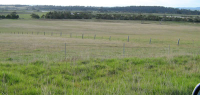
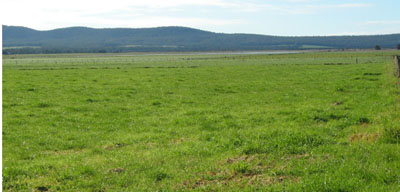
Broad alluvial plain. This map unit includes all modern flood plain deposits of the various rivers.
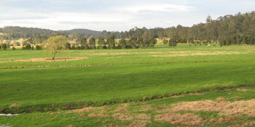
Genoa River flats, between Genoa and Gipsy Point
Native vegetation
Riparian forest.
Soils
All of the soils examined had slightly to moderately acidic very dark grey to very dark greyish brown clay loam silty clay loam to clay loam surface soils which became lighter in colour with depth as the level of organic matter decreased. The coarse sand contents through the profile were very low.
Site EG213
| Location: Cann River flats | Geo. Ref. 0691100E 5846300N |
| Australian Soil Classification: Vertic (Mottled-Sodic), Eutrophic, Grey DERMOSOL | Grey uniform textured soil |
| General landscape description: Alluvial plain | |
| Geology: Recent sediments | |
| Site description: Level plain >1% slope | |
| Land use: Grazing | |
| Native vegetation: Riparian forest | |
| Mapping unit: River flats (rf) |

Soil profile morphology
| Surface soil |
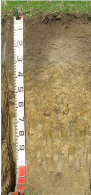 | ||
A11 | 0 – 15 cm | Very dark greyish brown (10YR3/2); silty clay loam; moderate fine (2 - 5 mm) granular structure; weak consistence moist; diffuse change to: | |
A12 | 15 – 35 cm | Dark greyish brown (10YR4/2); silty clay loam; weak medium (10 – 20 mm) polyhedral structure; firm consistence moist; diffuse change to: | |
| Subsoil | |||
B21 | 35 – 70 cm | Dark greyish brown (10YR4/2) with common distinct medium yellowish brown (10YR5/6) mottles; silty clay; moderate coarse polyhedral structure; very firm consistence moist; change to: | |
B22 | 70 – 110 cm | Grey (10YR5/1) with common distinct medium yellowish brown (10YR5/6) mottles; light clay; moderate coarse lenticular structure; very firm consistence moist. | |
Key profile features
| |||
| pH | Salinity rating | Sodicity | Dispersion | Slaking | |
| Surface soil (A11 horizon) | Slightly acid | Low | Non sodic | None | Slakes considerably |
| Subsoil (B21 horizon) | Slightly acid | Very low | Sodic | Strong | Slakes considerably |
| Deeper subsoil (70 -110 cm) | Moderately alkaline | Very low | Strongly sodic | Strong | Slakes considerably |
| Horizon | Depth cm | Field texture | pH water | pH CaCl2 | EC dS/m | Coarse sand % | Fine sand % | Silt % | Clay % | Field cap. % w/w | Wilt. point % w/w | PAW* water % w/w |
| A11 | 0-15 | ZCL | 6.4 | 6.2 | 0.27 | 6 | 24 | 36 | 20 | 41.3 | 18.9 | 22.4 |
| A12 | 15-35 | ZCL | 5.9 | 5.1 | 0.09 | 6 | 23 | 36 | 28 | 33.3 | 15.1 | 18.2 |
| B21 | 35-70 | ZC | 6.4 | 5.5 | 0.15 | 4 | 26 | 34 | 31 | 29.1 | 15.3 | 13.8 |
| B22 | 70-110 | MC | 8.3 | 7.0 | 0.17 | 0 | 33 | 28 | 34 | 32.0 | 18.1 | 13.9 |
| Depth | OrgC# | Total N | Free Fe2O3 % w/w | Exch. Al | Exchangeable cations cmol(+)/kg | Ca:Mg | ESP | ||||||
| cm | % | % | ppm | Ca | Mg | K | Na | Total | H | CEC | |||
| 0-15 | 4.8 | 0.39 | <10 | 14.0 | 3.1 | 0.44 | 0.13 | 16.7 | 11.0 | 27.7 | 4.5 | 1 | |
| 15-35 | 1.7 | 0.07 | 26 | 3.5 | 3.9 | 0.062 | 0.59 | 8.1 | 12.0 | 20.1 | 0.9 | 3 | |
| 35-70 | 0.73 | <10 | 1.5 | 6.1 | 0.07 | 1.8 | 9.5 | 7.8 | 17.3 | 0.2 | 10 | ||
| 70-110 | 0.44 | 1.3 | 9.1 | 0.066 | 3.7 | 14 | 14 | 0.1 | 26 | ||||
Management considerations
- Plant available water capacity (PAWC) is considered to be moderate-high (estimated at 65 mm) for this soil profile. This is based on an estimated effective rooting depth of 60 cm (i.e. surface soil and upper subsoil). The denser and more coarsely structured deeper subsoil is likely to restrict rooting depth.
- Infiltration of water will be rapid throughout the upper soil profile due to the well developed structure and pore space available.
- The relatively deep surface soil is moderately well structured and is friable when moist. Soil consistence when moist is also weak for this horizon. As a result of these attributes the surface soil will provide excellent seed-bed conditions, creating few limitations to root and water movement.
- The surface (A1) horizon has a moderate nutrient holding capacity (based on the sum of the exchangeable calcium, magnesium and potassium cations).
- The surface soil has moderate potassium content and no response to potassium fertilizer would be expected. However below this depth, the level of potassium is very low.
- The surface soil has high organic matter content. Soils such as these rely on organic matter to maintain soil structure. Maintaining organic matter levels will also assist in improving soil fertility and water holding capacity.
- Infiltration of water into the well structured surface soil will be quite high and this horizon will be well drained.
- The deep subsoil is sodic and coarsely structured which will significantly restrict deeper root and water movement.
| Location: Orbost River flats | Geo. Ref. 0634100E 5821200N |
| Australian Soil Classification: Melanic, Eutrophic, Black DERMOSOL | Black uniform textured soil |
| General landscape description: Alluvial plain | |
| Geology: Recent sediments | |
| Site description: Level plain >1% slope | |
| Land use: Grazing | |
| Native vegetation: Riparian forest | |
| Mapping unit: River flats (rf) |
Soil profile morphology
| Surface soil |  | |||||||||||||||||||||||||
A11 | 0 – 25 cm | Very dark grey (10YR3/1); clay loam; strong medium polyhedral structure, weak consistence moist; clear change to: | ||||||||||||||||||||||||
A12 | 25 – 55 cm | Black (10YR2/1); clay loam; moderate medium polyhedral structure; firm consistence moist: | ||||||||||||||||||||||||
Deep subsoil | ||||||||||||||||||||||||||
D | 70 – 105 cm | Very dark grey (10YR3/1); clay loam; weak to very weak coarse prismatic structure; firm consistence moist. | ||||||||||||||||||||||||
Key profile features
| ||||||||||||||||||||||||||
Soil profile characteristics
| ||||||||||||||||||||||||||
2 Complete after remoulding (20 hrs)
| Horizon | Depth cm | Field texture | pH water | pH CaCl2 | EC dS/m | Coarse sand % | Fine sand % | Silt % | Clay % | Field cap. % w/w | Wilt. point % w/w | PAW* water % w/w |
| A11 | 0-25 | CL | 5.9 | 5.0 | 0.12 | 1 | 28 | 30 | 35 | 40.6 | 23.3 | 17.3 |
| A12 | 25-55 | CL | 6.3 | 5.3 | 0.07 | 1 | 27 | 33 | 29 | |||
| A13 | 55-70 | CL | 6.4 | 5.4 | 0.08 | 2 | 28 | 33 | 29 | |||
| D | 70-105 | CL | 6.7 | 5.5 | 0.07 | 1 | 34 | 31 | 29 |
| Depth | Org C# | Total N | Free Fe2O3 | Exch. Al | Exchangeable cations cmol(+)/kg | Ca:Mg | ESP | ||||||
| cm | % | % | % w/w | ppm | Ca | Mg | K | Na | Total | H | CEC | ||
| 0-25 | 2.8 | 0.25 | <10 | 7.6 | 6.4 | 0.84 | 0.96 | 15.8 | 14 | 30.0 | 1.2 | 3 | |
| 25-55 | 2.5 | 0.19 | <10 | 10.0 | 7.1 | 0.22 | 0.63 | 18 | 14 | 32.0 | 1.4 | 2 | |
| 55-70 | 2.2 | 0.14 | <10 | 8.8 | 7.9 | 0.19 | 0.78 | 17.7 | 13 | 31.0 | 1.2 | 3 | |
| 70-105 | <10 | 6.9 | 8.3 | 0.15 | 0.84 | 16.2 | 9.5 | 25.5 | 0.9 | 3 | |||
Management considerations
- There are no impeding layers in the profile which allows plant roots deep penetration.
- The relatively deep surface soil is moderately well structured and is friable when moist. Soil consistence when moist is also weak for this horizon. As a result of these attributes the surface soil will provide excellent seed germination conditions and few other limitations to root and water movement.
- The nutrient holding capacity of this soil is high (based on the sum of the exchangeable calcium, magnesium and potassium cations)
- Potassium levels are high and no response to potassium fertilizer would be expected. However below 25 cm the levels are quite low.
- The subsoil is non-sodic and reasonably well structured. Root and water movement will not be significantly restricted as a result.
| Location: Orbost South | Geo. Ref. 631500E 5824200N |
| Australian Soil Classification: Melanic, Eutrophic, Black DERMOSOL | Black uniform textured soil |
| General landscape description: Alluvial plain | |
| Geology: Recent sediments | |
| Site description: Level plain >1% slope | |
| Land use: Grazing | |
| Native vegetation: Riparian forest | |
| Mapping unit: River flats (rf) |
Soil profile morphology
| Surface soil | |||||||||||||||||||||||||||
A11 | 0 – 30 cm | Very dark greyish brown (10YR3/2); clay loam, (high in organic matter); strong medium polyhedral structure; weak consistence moderately moist; gradual change to: | |||||||||||||||||||||||||
A12 | 30 – 70cm | Dark greyish brown (10YR4/2) distinctly mottled with fine common dark brown (7.5YR3/4) mottles ; fine sandy clay loam; moderate medium polyhedral structure; weak consistence moist; clear change to: | |||||||||||||||||||||||||
D | 70 – 110cm | Very dark grey (10YR3/1); silty clay loam; weak to moderate coarse prismatic structure; firm consistence moderately moist. | |||||||||||||||||||||||||
Key profile features
| |||||||||||||||||||||||||||
Soil profile characteristics
2Strong after remoulding | |||||||||||||||||||||||||||
| Horizon | Depth cm | Field texture | pH water | pH CaCl2 | EC dS/m | Coarse sand % | Fine sand % | Silt % | Clay % | Field cap. % w/w | Wilt. point % w/w | PAW* water % w/w |
| A1 | 0-30 | CL | 6.1 | 5.2 | 0.09 | 0 | 32 | 39 | 25 | 35.2 | 20.3 | 14.9 |
| A12 | 30-70 | FSCL | 6.4 | 5.5 | 0.08 | 0 | 44 | 26 | 22 | 30.7 | 14.1 | 16.6 |
| D | 70-110 | ZCL | 5.5 | 4.7 | 0.13 | 1 | 40 | 26 | 25 |
Sampled by auger
| Depth | Org C# | Total N | Free Fe2O3 | Exch Al | Exchangeable cations meq/100 g | Ca:Mg | ESP | ||||||
| cm | % | % | % w/w | ppm | Ca | Mg | K | Na | Total | H | CEC | ||
| 0-30 | 2.2 | 0.24 | 11 | 8.1 | 5.5 | 0.5 | 0.53 | 14.6 | 12.0 | 27.0 | 1.5 | 2 | |
| 30-70 | 11 | 8.5 | 5.9 | 0.21 | 0.56 | 14.6 | 9.2 | 24.2 | 1.5 | 2 | |||
| 70-110 | 42 | 4.6 | 4.0 | 0.22 | 0.62 | 9.4 | 16.0 | 25.5 | 1.2 | 2 | |||
Management considerations
- The plant available water content of this soil is moderate (65 mm based a rooting depth of 70 cm).
- The deep surface soil is well structured
- Infiltration of water into the well structured surface soil would be quite high. This horizon is also very well drained
- The nutrient holding capacity of the soil is high (based on the sum of the exchangeable cations)
- Potassium levels are moderate to high and any response to potassium fertilizer is unlikely
- The soil is slightly acid and unlikely to respond to lime.
| Location: Cann River Flats | Geo. Ref. 692200E 5849100N |
| Australian Soil Classification: Melanic, Sodic, Eutrophic, Grey DERMOSOL | Grey uniform textured soil |
| General landscape description: Alluvial plain | |
| Geology: Recent sediments | |
| Site description: Level plain >1% slope | |
| Land use: Grazing | |
| Native vegetation: Riparian forest | |
| Mapping unit: River flats (rf) |
[

Soil profile morphology
| Surface soil | |||||||||||||||||||||||||||
A11 | 0 – 30 cm | Very dark grey (10YR3/1); clay loam, high in organic matter; strong medium polyhedral structure; very weak consistence moist; gradual change to: | |||||||||||||||||||||||||
A12 | 30 – 50 cm | Dark greyish brown (10YR4/2) distinctly mottled with fine common dark brown (7.5YR3/4) mottles; silty clay loam; moderate medium polyhedral structure; weak consistence moist; gradual change to: | |||||||||||||||||||||||||
Subsoil | |||||||||||||||||||||||||||
B2 | 50 – 70 cm | Brown (10YR5/3) with many medium faint dark greyish brown (10YR4/2) mottles; silty clay; weak to moderate coarse prismatic structure; firm consistence moist ; diffuse change to: | |||||||||||||||||||||||||
Deep subsoil | |||||||||||||||||||||||||||
D | 70 – 105 cm | Dark greyish brown (10YR4/2) with common distinct medium brown (7.5YR5/4) mottles; sandy clay loam; weak coarse polyhedral structure; firm consistence moist. | |||||||||||||||||||||||||
Soil profile characteristics
Sampled by auger | |||||||||||||||||||||||||||
| Horizon | Depth cm | Field texture | pH water | pH CaCl2 | EC dS/m | Coarse sand % | Fine sand % | Silt % | Clay % | Field cap. % w/w | Wilt. point % w/w | PAW* water % w/w |
| A11 | 0-30 | CL | 5.6 | 4.9 | 0.08 | 6 | 31 | 30 | 23 | 33.4 | 14.0 | 19.4 |
| A12 | 50-70 | ZCL | 5.4 | 4.7 | 0.09 | 7 | 32 | 34 | 25 | |||
| A13 | 70-105 | ZCL | 5.9 | 5.0 | 0.11 | 7 | 26 | 34 | 31 |
| Depth | Org C# | Total N | Free Fe2O3 | Exch. Al | Exchangeable cations meq/100 g | Ca:Mg | ESP | ||||||
| cm | % | % | % w/w | ppm | Ca | Mg | K | Na | Total | H | CEC | ||
| 0-30 | 2.9 | 0.21 | 14 | 7.5 | 1.4 | 0.17 | 0.24 | 9.4 | 15.0 | 24.4 | 5.4 | 1 | |
| 50-70 | 48 | 3.3 | 2.4 | 0.12 | 0.28 | 6.1 | 12.0 | 18.1 | 1.4 | 2 | |||
| 70-105 | 12 | 2.8 | 4.9 | 0.13 | 0.62 | 8.5 | 8.2 | 16.7 | 0.6 | 4 | |||
© State of Victoria (Agriculture Victoria) 1996 - .

This work, Victorian Resources Online, is licensed under a Creative Commons Attribution 4.0 licence. You are free to re-use the work under that licence, on the condition that you credit the State of Victoria (Agriculture Victoria) as author, indicate if changes were made and comply with the other licence terms.
The licence does not apply to ‘branding’ or some ‘images or photographs’ that may be owned by third parties. We ask you to seek prior approval to use images using the VRO feedback form. Access to higher quality images can also be provided on request.
This page was last updated on .