
Bloomfield (Symbol: Bf)
Profile No. 45 (Aldrick et al, 1992)
Geology
Palaeozoic granites, granodiorites, gneissic metamorphics and related coarse crystalline plutonic rocks.
Landform
In the context of this report, the Bloomfield map unit encompasses rolling to steep hills with an elevation range of about 350 to 1100 m and an elevation range of 90 to 300 m. The slope gradients exceed 15% but are generally much steeper, commonly 30 – 50%.
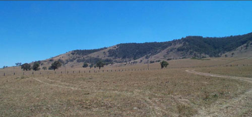
Bloomfield map unit: steep hills in the background; Dargo map unit: rolling low hills in the foreground.
Vegetation
Grassy dry forest with montane grassy woodland at higher altitudes.
Soils
The underlying rocks of this map unit weather relatively slowly and have high natural erosion rates due to the incomplete vegetation cover and steep slopes. This has resulted in shallow sandy soils that are weakly aggregated or apedal and exposed rock is common and may exceed 50% of the area. Soil may be up to
1.2 m depth in rock-free areas. The soils are generally brown sandy loams overlying reddish brown sandy clays to clayey sands. No separate components are described in this report and no soil pits were examined.
Profile No 45 (Aldrick et al, 1992)
| Location: Ensay | Geo. Ref. 0577800E 5862200N |
| Australian soil classification: Melanic Eutrophic, Red CHROMOSOL | Brown texture contrast soil |
| General landscape description: Steep low hills | |
| Geology: Palaeozoic granite | |
| Site Description: Lower east facing slope (37% slope) | |
| Land use: Grazing on annual pasture | |
| Original vegetation: Open forest | |
| Mapping unit: Bloomfield (previously mapped as Dargo, Component 1, but too steep for new unit definition) |
Soil profile morphology
| Surface soil | 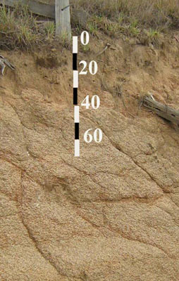 | ||
| A11 | 0-27 cm | Dark brown (7.5YR3/2); sandy loam; apedal; hard consistence dry; 5% granite fragments up to 8 mm; clear wavy change to: | |
| A12 | 27-50 cm | Strong brown (7.5YR5/6); gritty sandy loam; apedal; hard consistence when dry; 15% granite fragments up to 8 mm; clear wavy change to: | |
| Subsoil | |||
| B2 | 50 -80 cm | Yellowish red (5YR5/6); sandy clay; moderate coarse (25 mm) angular blocky structure; firm consistence moist; 25% quartz and weathering feldspar crystals up to 3 mm and dark mica grains; | |
| C | 80 – 90 cm+ | Strong brown (7.5YR5/6); sandy clay loam; moderate medium (20 mm) angular blocky structure; weathering granite; friable consistence, moist. |
Key profile features
- Bordering on a gradational soil but the slight texture contrast between the surface (A) horizons and the subsoil (B) horizons makes this a borderline texture contrast soil.
| Horizon | Depth cm | Field texture | pH water | EC dS/m | Gravel % | Coarse sand % | Fine sand % | Silt % | Clay % | Field cap. % w/w | Wilt. point % w/w | PAW* water % w/w |
| A11 | 0-10 | SL | 5.9 | <0.05 | 6 | 31 | 43 | 10 | 13 | |||
| A11 | 10-20 | SL | <0.05 | 12 | ||||||||
| A12 | 30-50 | SL | 6.7 | <0.05 | 22 | 37 | 42 | 11 | 11 | |||
| B2 | 60-80 | SC | 7.0 | <0.05 | 18 | 30 | 25 | 15 | 31 | |||
| C | 80-90 | SCL | 7.1 | <0.05 | 5 | 29 | 27 | 14 | 28 |
| Depth | OrgC# | Total N | Exch. Al | Exchangeable cations meq/100 g | Ca:Mg | Na % | ||||||
| cm | % | % | ppm | Ca | Mg | K | Na | Total | H | CEC | ||
| 0-10 | 2.2 | 0.16 | 4.0 | 1.0 | 0.5 | 0.05 | 5.6 | 8.2 | 13.7 | 4 | ||
| 10-20 | ||||||||||||
| 30-50 | 4.4 | 0.8 | 0.3 | 0.08 | 5.6 | 2.2 | 7.8 | 5.5 | ||||
| 60-80 | 10.6 | 2.5 | 0.5 | 0.3 | 13.9 | 4.3 | 18.2 | 4.2 | 2 | |||
| 80-90 | 11.3 | 2.9 | 0.5 | 0.4 | 15.1 | 4.8 | 19.9 | 3.9 | 3 | |||
Management considerations
- As the soils are sandy, the plant available water would be very low. However plants would be able to utilize light rain after the soils are dry.
- Sheet and rill erosion would be high and common where the topsoil is exposed.
- Soil depth in the steep cleared drainage lines is likely to be very shallow with considerable exposed rock.
© State of Victoria (Agriculture Victoria) 1996 - .

This work, Victorian Resources Online, is licensed under a Creative Commons Attribution 4.0 licence. You are free to re-use the work under that licence, on the condition that you credit the State of Victoria (Agriculture Victoria) as author, indicate if changes were made and comply with the other licence terms.
The licence does not apply to ‘branding’ or some ‘images or photographs’ that may be owned by third parties. We ask you to seek prior approval to use images using the VRO feedback form. Access to higher quality images can also be provided on request.
This page was last updated on .