
Bindi (Symbol: Bi)
EG200 | Soil Profile No. 33 (Aldrick et al, 1992)
Geology
Devonian marlstone and limestone.
Landform
Rolling low hills, mostly 500-600 m in elevation. The mapping unit may be subdivided into four components. Most of the area comprises long gentle slopes with smaller areas of steeper slopes, particularly northern slopes and rock outcrop, lower slopes and alluvial fans and valley flats and drainage lines.
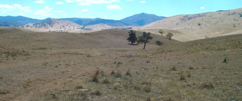
Undulating low hills of the Bindi map unit (foreground) are almost all cleared for grazing”
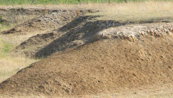
| Original vegetation Grassy woodland. Soils Component 1: Soils on long gentle slopes These soils form the majority of the soils of this unit. The surface soils are mostly dark reddish brown to dark brown strongly structured friable clay loams. The subsoils are strongly structured medium clays with reddish brown and red colours being predominant. Limestone generally occurs 0.5 and 1 m. One soil pit was excavated on this component (EG208). Component 2: Soils on steeper slopes, particularly northern slopes The soils on this component are generally shallow, less than 0.4 m and limestone may be exposed at the surface. The soil above the rock is similar in nature to component 1. No field or analytical data is available. Component 3: Soils on lower slopes and alluvial fans Land use | 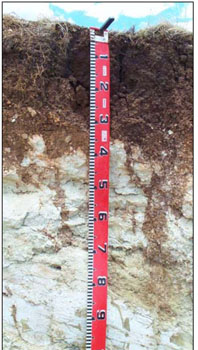 Photo: Shallow soils occur on steeper slopes |
Yellow texture contrast soils may occur in concave drainage lines
Site EG200
| Location: Bindi | Geo. Ref. 0573784E 5886803N |
| Australian soil classification: Haplic, Lithocalcic, Red DERMOSOL | Gradational soil on limestone |
| General landscape description: Undulating low hills | |
| Geology: Devonian limestone | |
| Site Description: Upper north facing slope | |
| Land use: Grazing on annual pasture | |
| Original vegetation: Grassy woodland | |
| Mapping unit: Bindi (Component 1) |
Soil profile morphology
| Surface soil | 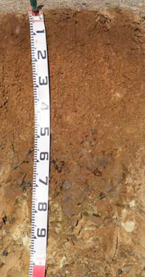 | ||
| A1 | 0 – 17 cm | Dark brown (7.5YR3/2); clay loam; moderate fine (2 – 5 mm) granular structure; firm consistence dry; clear change to: | |
| Subsoil | |||
| B21 | 17 – 30 cm | Reddish brown (2.5YR4/4); medium clay; strong medium (10 – 20 mm) polyhedral structure; very firm consistence dry; few (2 – 10 %) angular limestone pebbles (up to 10 mm in size); gradual change to: | |
| B22 | 30 – 40 cm | Red (2.5YR4/6); medium clay; strong medium (10 – 20 mm) angular blocky structure; very firm consistence dry; many (20 – 50%) angular tabular limestone pebbles (up to 20 mm in size); gradual change to: | |
| B23 | 40 – 55 cm | Red (2.5YR4/6); medium clay; very firm consistence dry; abundant (50 – 90 %) angular tabular limestone pebbles (up to 60 mm in size); clear change to: | |
| R | 55 – 110+ cm | Fractured limestone becoming impenetrable with depth. |
Key profile features
- Lack of texture contrast between the surface (A) horizon and the subsoil (B) horizon.
- The shallow occurrence of limestone rock.
| pH | Salinity rating | Sodicity | Dispersion | Slaking | |
| Surface soil (A1 horizon) | Strongly acid | Very low | Non sodic | None | Water stable |
| Subsoil (B21 horizon) | Moderately acid | Very low | Non sodic | None | Slakes partially |
| Deeper subsoil | Slightly acid | Very low | Non sodic | None | Slakes partially |
| Horizon | Depth cm | Field texture | pH water | pH CaCl2 | EC dS/m | Coarse sand % | Fine sand % | Silt % | Clay % | Field cap. % w/w | Wilt. point % w/w | PAW* water % w/w |
| A1 | 0-17 | CL | 5.3 | 4.6 | 0.11 | 8 | 18 | 23 | 41 | 34.5 | 15.5 | 19.0 |
| B21 | 17-30 | MC | 5.9 | 4.7 | 0.06 | 6 | 10 | 11 | 66 | 30.6 | 17.0 | 13.6 |
| B22 | 30-40 | MC | 6.2 | 5.7 | <0.05 | 2 | 7 | 16 | 70 | 31.8 | 19.7 | 12.1 |
| B3 | 40-55 | MC | 6.2 | 6.6 | <0.05 | 13 | 7 | 27 | 50 | 24.4 | 13.9 | 10.5 |
| Depth | OrgC# | Total N | Free Fe2O3 % w/w | Exch. Al | Exchangeable cations meq/100 g | Ca:Mg | Na % | ||||||
| cm | % | % | ppm | Ca | Mg | K | Na | Total | H | CEC | |||
| 0-17 | 4.3 | 0.38 | <10 | 7.3 | 1.5 | 0.74 | 0.085 | 9.6 | 9.5 | 19.1 | 4.9 | <1 | |
| 17-30 | 1.5 | 0.14 | <10 | 8 | 2.9 | 0.5 | 0.11 | 12 | 6.8 | 18.8 | 2.8 | <1 | |
| 30-40 | 1.3 | 12 | 8.7 | 4 | 0.33 | 0.15 | 13 | 7.5 | 20.5 | 2.2 | 1 | ||
| 40-55 | 0.61 | 14 | 8.3 | 3.9 | 0.29 | 0.14 | 13 | 5.8 | 18.8 | 2.2 | 1 | ||
Management considerations
Whole profile
- Plant available water here is considered to be moderate. Because of the variability in the depth of soil cover within this mapping unit, many soils will have low to very low water-holding capacity. Effective rooting depth is limited to the depth to rock.
- The surface soil here is strongly acid. This is inconsistent given the presence of lime in the subsoil. Lime is added to acid soils is to increase the availability of phosphorus and molybdenum so if soil tests taken across the paddock show the soils are deficient, superphosphate should be applied. If no response is observed, lime may used to alleviate the problem.
- The soils are low in soluble salts.
- Potassium levels are moderate and plant responses to potassium fertiliser are unlikely given the present grazing management practices.
- The nutrient holding capacities of the surface (A1 and B21) horizons are moderate (based on the sum of the exchangeable calcium, magnesium, potassium and sodium cations).
- The subsoil would be relatively well drained as there is no sharp increase in clay content at the A/B boundary. The subsoil horizons are non-sodic and not coarsely structured, which will enable plant roots to penetrate easily until they reach rock.
Soil Profile No. 33 (Aldrick et al, 1992)
| Location: Bindi | Geo. Ref. 0572400E 5891103N |
| Australian soil classification: Haplic, Lithocalcic, Brown DERMOSOL | Gradational soil |
| General landscape description: Undulating low hills | |
| Geology: Devonian limestone | |
| Site Description: Mid-slope of alluvial fan, 10% slope (sample site within an old disused sheepyard) | |
| Land use: Grazing on annual pasture | |
| Original vegetation: Open forest | |
| Mapping unit: Bindi (Component 3) |
No photo available
Soil profile morphology
| Surface soil | ||
| A1 | 0 – 10 cm | Very dark brown (10YR3/3); clay loam; moderate fine (5 - 10 mm) sub-angular blocky structure; very hard dry; clear change to: |
| A2 | 10 – 15 cm | Dark brown (7.5YR3/3); light clay; moderate medium (10 – 20 mm) angular blocky structure; very hard consistence dry; clear change to: |
Subsoil | ||
| B21 | 15 – 90 cm | Dark reddish brown (5YR3/4); medium clay; strong medium (10 – 20 mm) sub-angular blocky structure; firm consistence moist; diffuse change to: |
| B22 | 90 – 180 cm | Yellowish red (5YR4/6); medium clay; 2% calcareous nodules (2 mm) |
Key profile features
- Lack of texture contrast between the surface (A) horizon and the subsoil (B) horizon.
| pH | Salinity rating | Sodicity | Dispersion | Slaking | |
| Surface soil (A1 horizon) | Moderately acid | Very low | Non sodic | ||
| Subsoil (B21 horizon) | Sightly acid | Very low | Non sodic | ||
| Deeper subsoil | Slightly alkaline | Very low | Non sodic |
| Horizon | Depth cm | Field texture | pH water | pH CaCl2 | EC dS/m | Coarse sand % | Fine sand % | Silt % | Clay % | Field cap. % w/w | Wilt. point % w/w | PAW* water % w/w | |
| A11 | 0-5 | CL | 6.1 | 0.15 | 1 | 24 | 33 | 34 | |||||
| A11 | 5-10 | CL | 6.0 | <0.05 | |||||||||
| A2 | 10-15 | CL | 6.3 | <0.05 | 2 | 28 | 27 | 40 | |||||
| B21 | 20-30 | MC | 6.8 | <0.05 | 2 | 28 | 24 | 44 | |||||
| B22 | 90-120 | MC | 7.4 | <0.05 | 3 | 21 | 14 | 59 | |||||
| B22 | 1.5-1.8 | MC | 7.6 | <0.05 | 3 | 17 | 16 | 59 |
| Depth | OrgC# | Total N | Free Fe2O3 % w/w | Exch. Al | Exchangeable cations meq/100 g | Ca:Mg | Na % | ||||||
| cm | % | % | ppm | Ca | Mg | K | Na | Total | H | CEC | |||
| 0-5 | 4.2 | 0.4 | 2.7 | 11.8 | 1.3 | 2.1 | 0.05 | 15.3 | 11.7 | 27.0 | 9.1 | <1 | |
| 5-10 | |||||||||||||
| 10-15 | 1.8 | 0.19 | 3.0 | 9.8 | 0.7 | 1.0 | 0.05 | 11.6 | 8.8 | 20.4 | 14.0 | <1 | |
| 20-30 | 0.69 | 0.10 | 3.6 | 10.7 | 0.7 | 0.7 | 0.05 | 12.2 | 5.6 | 17.8 | 15 | <1 | |
| 90-120 | 4.4 | 13.9 | 1.0 | 1.0 | 0.2 | 16.1 | 11.2 | 27.3 | 14 | <1 | |||
| 1.5-1.8m | 4.0 | 16.9 | 2.8 | 1.0 | 0.3 | 21.0 | 7.8 | 28.8 | 6 | <1 | |||
Management considerations
Whole profile
- Plant available water here is considered to be moderate. Roots were found to 60 cm with some at 90 cm.
- The surface soil here is moderately acid. For pastures, it is unnecessary to add lime.
- Potassium levels are high so plant responses to potassium fertiliser are most unlikely. However it should be noted the sampling site was within an old sheepyard.
- The nutrient holding capacity of the surface (A1 and B21) horizons is moderate (based on the sum of the exchangeable calcium, magnesium, potassium and sodium cations).
- The subsoil would be relatively well drained as there is no sharp increase in clay content at the A/B boundary. The subsoil horizons are non-sodic and not coarsely structured, which will enable plant roots to penetrate easily.
© State of Victoria (Agriculture Victoria) 1996 - .

This work, Victorian Resources Online, is licensed under a Creative Commons Attribution 4.0 licence. You are free to re-use the work under that licence, on the condition that you credit the State of Victoria (Agriculture Victoria) as author, indicate if changes were made and comply with the other licence terms.
The licence does not apply to ‘branding’ or some ‘images or photographs’ that may be owned by third parties. We ask you to seek prior approval to use images using the VRO feedback form. Access to higher quality images can also be provided on request.
This page was last updated on .