
Tubbut (Symbol: Tu)
Geology
Granite.
Landform
The Tubbut map unit encompasses steep hills to steep mountains at an elevation range of about 200 to 800 m and a relief range of up to 500 m. From about Suggan Buggan to Cabanandra the area has been arbitrarily subdivided into the Ambyne map unit, which has slopes generally less than 32% and the Tubbut map unit, with slopes generally greater than 32%.
No attempt has been made to separate this map unit into separate components.
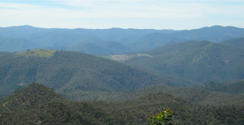
Steep hills and steep mountains with slopes greater than 32% near Suggan Buggan. This photo was taken south west of Suggan Buggan looking east.
Original vegetation
Grassy woodland, some shrubby dry forest.
Soils
The soils are likely to be slightly acidic reddish brown to brown coarse sandy loams overlying coarse sandy clays with granite rock occurring before 1 m. Shallow soils similar to these are described under the Ambyne map unit.
Land use
Mostly uncleared.
© State of Victoria (Agriculture Victoria) 1996 - .

This work, Victorian Resources Online, is licensed under a Creative Commons Attribution 4.0 licence. You are free to re-use the work under that licence, on the condition that you credit the State of Victoria (Agriculture Victoria) as author, indicate if changes were made and comply with the other licence terms.
The licence does not apply to ‘branding’ or some ‘images or photographs’ that may be owned by third parties. We ask you to seek prior approval to use images using the VRO feedback form. Access to higher quality images can also be provided on request.
This page was last updated on .