
Stratford (Symbol: Sf)
EG260 | Profile No. 64 (Aldrick, et al 1992)
Geology
Pleistocene alluvial sediments. On the geology maps these areas are mapped as Qp5, which is the second youngest of the six alluvial terraces deposited during the Pleistocene Period. This terrace has a similar distribution to the Briagolong map unit (Qp4) and is about 20 to 30 m lower. Minor areas of the Stratford map unit (i.e. Qp5) terraces occur on the alluvial plains adjoining the Mitchell, Nicholson and Tambo Rivers. Larger areas of this map unit occur in the Maffra area.
Landform
Gently undulating plain. This map unit occurs on the lower areas of the plain, but above the present flood plains of the Mitchell, Nicholson and Tambo Rivers. The map unit is dissected where it adjoins drainage lines and streams.
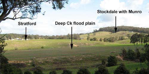
Looking south-west from Deep Creek Road, Wiseleigh. Stratford alluvial terrace with the hills in the background mapped
as Stockdale (comprising sandy texture contrast soils) with Munro (deep sands)
| Original vegetation Plains grassy woodland. Soils The soils are all texture contrast soils. The surface soils are strongly to moderately acidic dark greyish brown sandy loams to sandy clay loams and often have a bleached subsurface soil. Slightly acid dark brown to yellowish brown medium to heavy clays occur at a variable depth, generally before 25 cm with grey or strong brown mottles in the deeper subsoil. Quartz pebbles may occur throughout the profile, often in the surface horizons. | 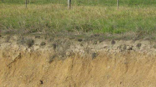 |
| Location: Bairnsdale East | Geo. Ref.: 559800E 5814800N |
| Australian Soil Classification: Eutrophic, Subnatric, Grey SODOSOL | Grey sodic texture contrast soil |
| General landscape description: Gently undulating plain | |
| Geology: Pleistocene alluvial sediments | |
| Site description: Almost level, within a broad drainage depression | |
| Land use: Grazing | |
| Native vegetation: Grassy woodland | |
| Map unit: Stratford/riverine/Perry complex |
Soil profile morphology
Surface soil
| A1 | 0 – 15 cm | Very dark to dark greyish brown; fine sandy loam to silty loam; clear change to: | 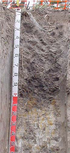 | |||||
A2 | 15 – 20/30 cm | Light brownish grey; fine sandy loam; abrupt wavy change to; | ||||||
Subsoil | ||||||||
B21 | 15/20 – 110 cm | Dark greyish brown; medium clay; common (10 – 20%) cobbles (<200 mm); diffuse change to: | ||||||
D | 110 – 150 cm | Light brownish grey and yellow brown mottles; medium clay. | ||||||
The colours of the upper part of the B horizon are much darker than normal for the Stratford map unit. This is most likely due to its low position in the landscape. It is likely the upper 110 cm of the profile represents a later alluvial deposit. Nevertheless the soil textures accord with those of the Stratford map unit. No soil samples were taken from this pit. A nearby site in the same position in the landscape (i.e. slight depression on the plain) was sampled by Aldrick et al. (1992). Their results are given in the following tables. Key profile features
Profile No. 64 (Aldrick et al, 1992)
Soil profile characteristics | ||||||||
| Horizon | Depth cm | Field texture | pH water | pH CaCl2 | EC dS/m | Coarse sand % | Fine sand % | Silt % | Clay % | Field cap. % w/w | Wilt. point % w/w | PAW* water % w/w |
| A1 | 0-5 | ZL | 5.0 | 0.06 | 8 | 47 | 27 | 14 | ||||
| A2 | 10-20 | ZCL | 5.5 | 0.05 | 6 | 38 | 27 | 18 | ||||
| B21 | 30-35 | MC | 5.4 | 0.10 | 3 | 24 | 33 | 39 | ||||
| B22 | 60-80 | LC | 6.0 | 0.35 | 4 | 20 | 21 | 53 | ||||
| B23 | 90-110 | LC | 6.6 | 0.54 | 4 | 31 | 17 | 48 |
| Depth | OrgC# | Total N | Free Fe2O3 | Exch. Al | Exchangeable cations cmol(+)/kg | Ca:Mg | ESP | ||||||
| cm | % | % | % w/w | ppm | Ca | Mg | K | Na | Total | H | CEC | ||
| 0-5 | 2.18 | 0.18 | 0.8 | 1.1 | 1.3 | 0.3 | 0.2 | 2.9 | 12.5 | 0.9 | 2 | ||
| 10-20 | 1.01 | 0.09 | 0.8 | 1.0 | 1.3 | 0.2 | 0.3 | 2.8 | 10.4 | 0.8 | 3 | ||
| 30-35 | 2.6 | 1.2 | 4.3 | 0.1 | 1.6 | 7.2 | 16.2 | 0.3 | 10 | ||||
| 60-80 | 3.9 | 1.5 | 8.5 | 0.2 | 4.9 | 15.1 | 22.0 | 0.2 | 22 | ||||
| 90-110 | 3.1 | 1.6 | 8.9 | 0.2 | 5.7 | 16.4 | 20.8 | 0.2 | 27 | ||||
Management considerations
Surface (A) horizons
- The surface soil is strongly acid and it is likely the pastures could show a marked response to lime, particularly given the low calcium levels in the soil. Lime should first be added in test strips to see whether it is warranted.
- Potassium levels are at deficiency levels and a response to added potassium may be expected, provided there are no other nutrient deficiencies.
- The calcium to magnesium ratios are low and some nutrient deficiencies (eg calcium deficiency) could occur.
- The subsoil is clayey, sodic and has low calcium to magnesium ratio. Such soils are a likely to be dispersive, coarsely structured and restrictive to root development.
- Strongly sodic soils occur in the deeper subsoil.
- Harmful levels of soluble salts occur in the deeper subsoil.
© State of Victoria (Agriculture Victoria) 1996 - .

This work, Victorian Resources Online, is licensed under a Creative Commons Attribution 4.0 licence. You are free to re-use the work under that licence, on the condition that you credit the State of Victoria (Agriculture Victoria) as author, indicate if changes were made and comply with the other licence terms.
The licence does not apply to ‘branding’ or some ‘images or photographs’ that may be owned by third parties. We ask you to seek prior approval to use images using the VRO feedback form. Access to higher quality images can also be provided on request.
This page was last updated on .