
Briagolong (Symbol: Br)
EG253 | Profile No. 62 (Aldrick et al, 1992) | Sample No. GR2 (Little and Ward) | Sample No. GR51 (Little and Ward)
Geology
Pleistocene alluvial sediments. On the geology maps these areas are mapped as Qp4, which is the third youngest of the six alluvial terraces deposited during the Pleistocene Period. Larger areas of this map unit occur in the Maffra area.
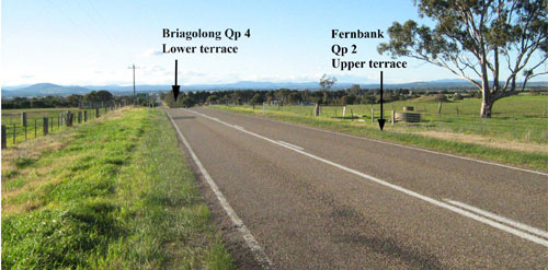
This photo, looking north on the Bairnsdale – Bengworden road about 3 km south of Princes Highway, shows the break
in the landscape between the Fernbank (higher) and the Briagolong (lower) Map units.
Landform
This map unit occurs on the almost level plains to gently undulating plains immediately west and south of Bairnsdale and the gently undulating plains west of Johnsonville. The map unit is somewhat dissected where it adjoins drainage lines and streams.
Original vegetation
Plains grassy woodland
Soils
The soils are texture contrast soils. The surface soils are strongly to moderately acidic dark greyish brown fine sandy loams to sands and often have a bleached subsurface soil. Sodic and slightly acid yellowish brown to brownish yellow dense and coarsely structured medium to heavy clays occur at a variable depth, generally before 50 cm with grey or strong brown mottles in the deeper subsoil. Quartz pebbles may occur throughout the profile, often in the surface horizons.
Previous maps and reports
This map unit is included within the Red Gum 1 and 2 and Salt Creek Land Systems as described by Aldrick et al. (1992)
Land use
Most of the land is cleared, mainly for grazing.
| Location: Nicholson | Geo. Ref.: 566100E 5810900N |
| Australian Soil Classification: Magnesic (and Eutrophic), Subnatric, Brown SODOSOL | Sodic brown texture contrast soil |
| General landscape description: Undulating rises | |
| Geology: Pleistocene alluvial sediments | |
| Site description: Upper slope, south aspect, 5% slope | |
| Land use: Grazing | |
| Original vegetation: Grassy woodland | |
| Map unit: Briagolong |
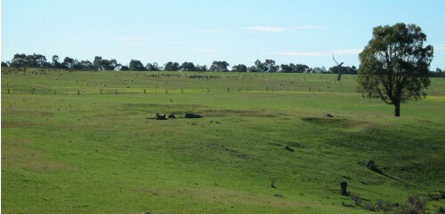
Photo looking north-east from near the soil pit
Soil Profile Morphology
Surface soil
| A | 0 – 15cm | Very dark greyish brown (10YR3/2); fine sandy clay loam; weak medium subangular blocky structure; firm consistence dry; abrupt change to: | 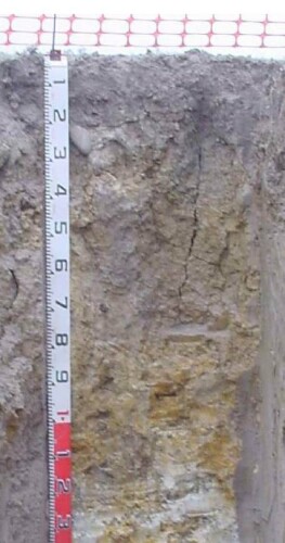 EG253 profile |
| Subsoil | |||
| B21 | 15 – 40 cm | Dark brown (10YR4/3); medium clay; strong very coarse columnar structure, parting to strong fine angular blocky; very strong consistence dry; few (<10 %) rounded cobbles (<200 mm); diffuse change to: | |
| B22 | 40 – 90 cm | Greyish brown (2.5Y5/3); light medium clay; strong coarse very prismatic to lenticular structure, parting to strong fine angular blocky; very strong consistence moderately moist; diffuse change to: | |
| B23 | 90 – 120 cm | Greyish brown (2.5Y5/3) few (<10%) coarse dark yellowish brown (10YR4/8) mottles; light medium clay; strong medium prismatic structure; very firm moderately moist; diffuse change to: | |
| C1 | 120 – 170 cm | Light grey (2.5Y7/3) with many (20-50%) very coarse (>30 mm) yellowish brown (10YR5/8) mottles; light clay; massive. | |
- Strong texture contrast between the surface (A) and subsoil (B) horizons
- Quartz cobbles present in the upper subsoil.
Soil profile characteristics
| pH | Sodicity | Slaking | Dispersion Dry | Dispersion Remoulded | |
| Surface soil (A horizon) | Strongly acid | Non-sodic | Water stable | Nil (2 hours), Nil (20 hours) | Slight (2 hours), Slight (20 hours) |
| Subsoil (B21 horizon) | Moderately acid | Sodic | Water stable | Nil (2 hours), Slight (20 hours) | Strong (2 hours), Strong (20 hours) |
| Deep subsoil (B23 horizon) | Slightly alkaline | Strongly sodic | Considerable | Slight (2 hours), Slight (20 hours) | Slight (2 hours), Strong (20 hours) |
| Horizon | Depth cm | Field texture | pH water | pH CaCl2 | EC dS/m | Coarse sand % | Fine sand % | Silt % | Clay % | Field cap. % w/w | Wilt. point % w/w | PAW* water % w/w |
| A | 0-15 | FSCL | 5.4 | 4.6 | 0.07 | 17 | 55 | 17 | 7 | 17 | 4.8 | 12.2 |
| B21 | 15-40 | MHC | 5.9 | 4.8 | 0.13 | 9 | 31 | 12 | 46 | 28.1 | 16.7 | 11.4 |
| B22 | 40-90 | MC | 7.8 | 6.6 | 0.26 | 7 | 36 | 15 | 38 | 27.1 | 15.6 | 11.5 |
| B23 | 90-120 | MC | 7.9 | 7.3 | 0.96 | 2 | 27 | 25 | 41 | 35.3 | 13.3 | 12.0 |
| B24 | 120-170 | LC | 7.7 | 7.2 | 0.89 | 1 | 43 | 29 | 24 | 33.1 | 14.1 | 19.0 |
| Depth | OrgC# | Total N | Free Fe2O3 | Exch. Al | Exchangeable cations cmol(+)/kg | Ca:Mg | ESP | ||||||
| cm | % | % | % w/w | ppm | Ca | Mg | K | Na | Total | H | CEC | ||
| 0-15 | 1.9 | 0.15 | 25 | 1.7 | 1.1 | 0.1 | <0.1 | 3 | 6 | 9 | 1.6 | 4 | |
| 15-40 | 42 | 1.7 | 7.7 | 0.3 | 1.2 | 11 | 9.5 | 20.5 | 0.3 | 6 | |||
| 40-90 | <5 | 0.8 | 7.6 | 0.2 | 2.4 | 11 | 3.4 | 14.4 | 0.1 | 17 | |||
| 90-120 | <5 | 0.7 | 8.4 | 0.2 | 4.3 | 14 | 2.9 | 16.9 | 0.1 | 25 | |||
| 120-170 | <5 | 0.6 | 6.1 | 0.1 | 2.5 | 9.3 | 1.8 | 11.1 | 0.1 | 23 | |||
Management considerations
Whole profile
- The plant available water capacity is considered to be low (estimated at 38 mm) based on an effective rooting depth of 30 cm. The dense upper subsoil is likely to restrict the effective rooting depth.
- The surface soil is strongly acid but it is unlikely the pastures could show a response to lime.
- The low wilting point indicates plants will be able to use very light rains when the soil is dry. Due to the low water storage capacity, plants will soon suffer moisture stress if follow-up rains don’t occur.
- Potassium levels are very low and a response to added potassium would be expected.
- Both the water holding capacity and the nutrient holding capacity is low. This can be enhanced by increasing the organic matter content of the soil by improving grazing management.
- The subsoil is dense, sodic and cracks when dry. This will significantly restrict root growth in the subsoil.
- Soluble salt levels increase with depth and are high in the deeper subsoil. This may restrict the growth of deeper rooted salt sensitive species.
Profile No. 62 (Aldrick et al, 1992)
| Location: 2 km south of Bairnsdale | Geo. Ref.: 552900E 5810800N |
| Australian Soil Classification: Eutrophic, Mottled-Subnatric, Brown SODOSOL (Thick very gravelly) | |
| Map unit: Briagolong. Deep gravelly brown sodic texture contrast soil |
| Depth cm | Colour | Texture | pH | TSS % | Grv % | CS % | FS % | Silt % | Clay % | Org C % | Tot N % | Exchangeable cations cmol(+)/kg | Ca:Mg | ESP | ||||
| Ca | Mg | K | Na | CEC | ||||||||||||||
| 0-10 | Very dark greyish brown | SL | 4.8 | 0.02 | 16 | 24 | 49 | 16 | 9 | 1.9 | 0.16 | 1.7 | 0.8 | 0.2 | 0.1 | 12.5 | 1.31 | 1 |
| 30-50 | Mottled yellowish brown and reddish brown | SL | 5.6 | 0.01 | 57 | 28 | 51 | 13 | 6 | 1.0 | 0.4 | 0.1 | 0.1 | 2.9 | 2.5 | 3 | ||
| 60-75 | Mottled yellowish brown and reddish brown | HC | 6.4 | 0.05 | 7 | 8 | 17 | 4 | 70 | 2.9 | 8.2 | 0.2 | 3.1 | 23.7 | 0.4 | 13 | ||
| 90-120 | Mottled yellowish brown and reddish brown | HC | 5.5 | 0.05 | 7 | 11 | 24 | 8 | 56 | 1.2 | 6.9 | 0.2 | 3.0 | 18.7 | 0.2 | 16 | ||
Sample No. GR2 (Little and Ward)
| Location: Simms Road, Johnsonville | Map ref.: 570600E 5812650N |
| Australian Soil Classification: Eutrophic, Mottled-Subnatric, Brown SODOSOL | |
| Map unit: Briagolong |
| Depth cm | Colour | Texture | pH | TSS % | Grv % | CS % | FS % | Silt % | Clay % | Org C % | Tot N % | Exchangeable cations cmol(+)/kg | Ca:Mg | ESP | ||||
| Ca | Mg | K | Na | CEC | ||||||||||||||
| 0-10 | Grey | FSL | 5.5 | 0.04 | 10 | 45 | 26 | 4 | 3.0 | 0.3 | 2.9 | 2.2 | 0.48 | .06 | 14.9 | 1.3 | 0 | |
| 20-30 | Mottled yellowish brown and dark brown | LMC | 6.3 | 0.05 | 9 | 30 | 22 | 39 | 2.5 | 8.7 | 0.13 | 1.8 | 17.2 | 0.3 | 10 | |||
| 120-135 | Mottled greyish brown and yellowish brown | LMC | 6.7 | 0.22 | 0 | 23 | 34 | 42 | 1.4 | 11.2 | 0.08 | 6.2 | 19.0 | 0.1 | 33 | |||
Sample No. GR51 (Little and Ward)
| Location: Buchannan’s Road., Hillside | Geo. Ref.: 546300E 5810250N |
| Australian Soil Classification: Magnesic (and Eutrophic), Mottled-Subnatric, Brown SODOSOL | Brown sodic texture contrast soi |
| Map unit: Briagolong |
| Depth cm | Colour | Texture | pH | TSS % | Grv % | CS % | FS % | Silt % | Clay % | Org C
| Tot N
| Exchangeable cations cmol(+)/kg | Ca:Mg | ESP | ||||
Ca | Mg | K | Na | CEC | ||||||||||||||
| 0-10 | Dark greyish brown | SL | 5.7 | 0.02 | 35 | 40 | 12 | 10 | 0.9 | 0.07 | 1.6 | 1.1 | 0.14 | 0.04 | 7.0 | 1.5 | 0 | |
| 20-30 | Mottled light brownish grey and strong brown | MC | 6.0 | 0.03 | 19 | 22 | 7 | 51 | 1.8 | 7.4 | 0.12 | 1.7 | 18.6 | 0.2 | 9 | |||
| 120-135 | Mottled yellowish brown and greyish brown | MC | 6.3 | 0.16 | 11 | 19 | 17 | 52 | 1.4 | 8.6 | 0.10 | 5.9 | 18.0 | 0.2 | 33 | |||
© State of Victoria (Agriculture Victoria) 1996 - .

This work, Victorian Resources Online, is licensed under a Creative Commons Attribution 4.0 licence. You are free to re-use the work under that licence, on the condition that you credit the State of Victoria (Agriculture Victoria) as author, indicate if changes were made and comply with the other licence terms.
The licence does not apply to ‘branding’ or some ‘images or photographs’ that may be owned by third parties. We ask you to seek prior approval to use images using the VRO feedback form. Access to higher quality images can also be provided on request.
This page was last updated on .