
Stockdale (Symbol: Sd)
EG221 | EG250 | EG251 | EG252 | Profile No. 49 (Aldrick, et al 1992) | Profile No. 51 (Aldrick et al, 1992) | Profile No. 52 (Aldrick et al, 1992) | Profile No. 63 (Aldrick et al, 1992)
Geology
Neogene (late Tertiary) alluvial sediments. The Tertiary sediments form the oldest ‘terraces’ and outwash fans from the uplands. As these sediments are derived from material higher in the mountains, their nature will depend on the rock types in the former upper catchment. There also will be changes in sediment size further down the depositional sequence. For example, the soils east of the Tambo River and south of the highway are mostly fine textured soils, with a sandy loam to fine sandy loam surface soil sharply separated from a medium to heavy clay subsoil at about 30 to 50 cm.
This early depositional sequence has been strongly dissected over time and sands, probably windblown from the many drainage lines, cover much of the area. Most of the soils are texture contrast soils, generally with medium clay subsoils occurring at around 30-50 cm, although some sub-soils are clayey sands and sandy clays. Almost invariably, the surface soils are acidic sands or sandy loams. Deep sands occur over about 30% of the area, except east of the Tambo River and south of the Highway, where the percentage of deep sand is probably less than 10%.
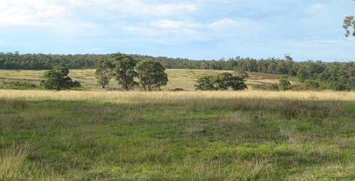
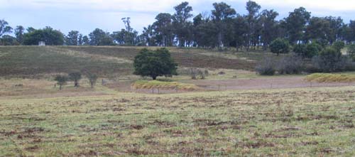
Landform
Rolling low hills. In the late Tertiary it is most likely the area was an alluvial plain but since then has been dissected and subject to periods of aridity, resulting in areas of deep sand cover. Where deep sands also occur, the area is mapped as the Stockdale with Munro map unit (Symbol: Sd/Mu).
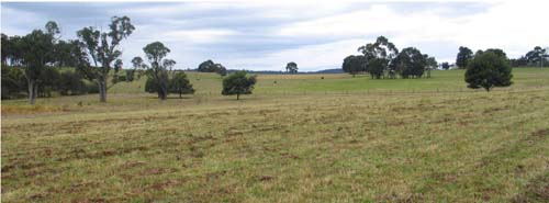
Original vegetation
Lowland forest.
Soils
The soils of the Stockdale map unit are all texture contrast soils. The surface soils are strongly to moderately acidic and range from dark greyish brown loamy sands to sandy loams. Invariably they have a bleached subsurface soil. Brown medium to heavy clays occur at a variable depth, generally before 50 cm, typically with yellowish brown, grey or strong brown mottles. The sandy surface soils have a low nutrient and water holding capacity if the organic matter levels are low and are also prone to wind erosion (EG 221, EG 250, EG 251, and EG 252).
The Munro map unit is arbitrarily defined as when the depth of sand exceeds 1 m. If the sand is sufficiently deep, ‘coffee rock’ occurs in the subsoil (refer to landform description Munro site EG 220).
Previous maps and reports
This map unit is included within the Stockdale and Westbury Land Systems as described by Aldrick et al. (1992).
Land use
Much of the land covered in this report is cleared and used for grazing. East of Swan Reach and north-east of Lakes Entrance most of the land is covered by lowland forest.
Site EG221
| Location: Lake Tyers | Geo. Ref.: 597000E 5812970N |
| Australian Soil Classification: Vertic, Subnatric, Brown SODOSOL | Sodic brown texture contrast soil |
| General landscape description: Undulating rises | |
| Geology: Neogene sediments (Late Tertiary) | |
| Site description: Simple upper slope 2% north east | |
| Land use: Grazing | |
| Native vegetation: Lowland forest | |
| Map unit: Stockdale | |
| This map unit will be renamed ‘Waygara’ in the Orbost map series | |
Soil profile morphology
Surface soil
| A1 | 0 – 20/30 cm | Dark greyish brown (10YR4/2); sandy loam; weak medium (10 – 20 mm) polyhedral structure; firm moist; clear wavy change to: | 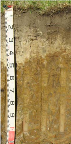 |
| A2 | 0/30 – 50/35 cm | Pale brown (10YR6/3) conspicuously bleached (10YR/8/1d); sandy loam or loamy sand; apedal, single grain; firm consistence dry; sharp change to: | |
| Subsoil | |||
| B21 | 50/35 – 80 cm | Yellowish brown (10YR5/6); heavy clay; moderate coarse (20 – 50 mm) polyhedral structure; strong consistence, moist; diffuse change to: | |
| B22 | 80 – 110 cm | Yellowish brown (10YR5/6) with greyish brown (10YR5/2) and increasing yellowish red (5YR5/6) mottles; heavy clay; moderate coarse (20 – 50 mm) lenticular structure; strong consistence moist. |
Key profile features
- Strong texture contrast between the surface (A) horizons and the subsoil (B) horizons.
- Conspicuously bleached subsurface (A2) horizon.
| pH | Sodicity | Slaking | Dispersion Dry | Dispersion Remoulded | |
| Surface soil (A1 horizon) | Moderately acid | Non-sodic | Water stable | Nil (2 hours), Nil (20 hours) | Nil (2 hours), Nil (20 hours) |
| Subsoil (B21 horizon) | Strongly acid | Sodic | Partial | Slight (2 hours), Slight (20 hours) | Nil (2 hours), Slight (20 hours) |
| Deeper subsoil (80-110 cm) | Strongly acid | Strongly sodic | Considerable | Nil (2 hours), Nil (20 hours) | Slight (2 hours), Slight (20 hours) |
| Horizon | Depth cm | Field texture | pH water | pH CaCl2 | EC dS/m | Coarse sand % | Fine sand % | Silt % | Clay % | Field cap. % w/w | Wilt. point % w/w | PAW* water % w/w |
| A1 | 0-20/30 | SL | 5.9 | 4.6 | 0.06 | 43 | 29 | 11 | 8 | 12.9 | 5.7 | 7.2 |
| A2 | 20/30-50/35 | LS | 5.3 | 4.1 | <0.05 | 48 | 29 | 12 | 6 | 13.9 | 3.0 | 10.9 |
| B21 | 50/35-80 | HC | 5.0 | 4.0 | <0.05 | 12 | 14 | 13 | 59 | 39.2 | 22.3 | 16.9 |
| B22 | 80-110 | HC | 5.4 | 4.4 | <0.05 | 15 | 13 | 15 | 54 | 36.5 | 20.8 | 15.7 |
| Depth | OrgC# | Total N | Free Fe2O3 | Exch. Al | Exchangeable cations cmol(+)/kg | Ca:Mg | ESP | ||||||
| cm | % | % | % w/w | ppm | Ca | Mg | K | Na | Total | H | CEC | ||
| 0-20/30 | 2.9 | 0.16 | 22 | 3.3 | 1.3 | 1 | 0.27 | 5.9 | 10.0 | 15.9 | 2.6 | 2 | |
| 20/30-50/35 | 0.57 | <0.05 | 74 | 0.51 | 0.33 | 0.15 | 0.12 | 1.1 | 3.6 | 4.7 | 1.5 | 3 | |
| 50/35-80 | 0.49 | <0.05 | 530 | 0.67 | 5.6 | 0.51 | 1.3 | 8.1 | 13.0 | 21.1 | 0.1 | 6 | |
| 80-110 | 0.37 | <0.05 | 110 | 0.21 | 9.9 | 0.32 | 3.2 | 14 | 8.0 | 22.0 | <0.1 | 15 | |
Management considerations
Whole profile
- The plant available water capacity of the soil is considered to be low (estimated at 54 mm) for the top 50 cm of the soil profile.
- The subsoil is high in clay and coarsely structured which will restrict root movement.
- The sand surface horizons are very well draining but have a low water storage capacity. The low wilting points (i.e. 5.7 and 3.0) indicate plants will be able to utilise light rains falling on dry soil. However, due to the low water storage capacity, plants will soon suffer moisture stress unless further rain occurs. Organic matter is an important source of nutrient holding capacity as well as enhancing water holding capacity in sandy soils.
- The sandy surface soil will also be prone to wind erosion if plant cover is removed where blow-outs can occur.
- The surface horizons have a moderate inherent fertility (based on the sum of the exchangeable cations).
- The surface soil is quite high in potassium and no response to potassium fertilisers would be expected.
- The dense and coarsely structured upper (B21) subsoil is sodic. This will restrict the downward movement of plant roots and water. The temporary build up of water on top of this less permeable layer may be beneficial for deeper-rooted plants as it prevents deep drainage of water away from plant roots.
- Sodic subsoils are typically moderately to strongly dispersive, but here are slightly dispersive. This is because of the high exchangeable aluminium.
- The upper (B21) subsoil has a relatively moderate inherent fertility throughout (based on the sum of the exchangeable calcium, magnesium and potassium cations). The cations are dominated by exchangeable magnesium which may create nutrient imbalances.
- The level of soluble salts is low.
Site EG 250
| Location: Flaggy Creek | Geo. Ref.: 542400E, 5821000N |
| Australian Soil Classification: Haplic, Mesotropic, Brown CHROMOSOL (Deep sandy) | Brown texture contrast soil |
| General landscape description: Undulating low hills | |
| Geology: Neogene sediments | |
| Site description: North-west slope of low rise (7%) | |
| Land use: Grazing | |
| Native vegetation: Lowland forest | |
| Map unit: Stockdale with Munro complex |
Soil profile morphology
Surface soil
| A1 | 0-25 cm | Very dark grey (10YR3/1); loamy sand; weak medium sub-angular blocky; very weak consistence moderately moist; pH5.3; clear smooth change to: | 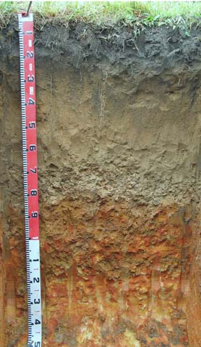 |
| A21 | 25-65 cm | Yellowish brown (10YR5/4) sand; single grain; very weak consistence moderately moist; pH5.5; clear smooth change to: | |
| A22 | 65-85 cm | Light yellowish brown (10YR6/4); loamy sand; single grain; very weak consistence moist; many coarse ferruginous nodules; pH5.7; abrupt change to: | |
| Subsoil | |||
| B2 | 85-120 cm | Strong brown (7.5YR5/6) with many coarse prominent dark yellowish brown (10YR4/6) and light yellowish brown (10YR6/5) mottles; medium clay with sand; weak medium angular blocky structure; firm consistence moderately moist; pH 5.5; gradual change to: | |
| C | 120-150+cm | Yellow (10YR7/6) with many coarse prominent light olive brown (2.5YR5/8) mottles; clayey sand; massive; firm consistence moderately moist; pH 5.3 |
Key profile features
- Abrupt texture contrast between the sand surface horizons (A horizons) and the clay subsoil (B horizon).
- Conspicuously bleached subsurface.
| pH | Sodicity | Slaking | Dispersion Dry | Dispersion Remoulded | |
| Surface soil A1 horizon | Strongly acid | Non-sodic | Water stable | Nil (2 hours), Nil (20 Hours) | Nil (2 hours), Nil (20 Hours) |
| Subsurface A21 horizon | Moderately acid | Non-sodic | Considerable | Nil (2 hours), Nil (20 Hours) | Nil (2 hours), Nil (20 Hours) |
| Subsoil B2 horizon | Moderately acid | Non-sodic | Considerable | Nil (2 hours), Nil (20 Hours) | Nil (2 hours), Nil (20 Hours) |
| Horizon | Depth cm | Field texture | pH water | pH CaCl2 | EC dS/m | Coarse sand % | Fine sand % | Silt % | Clay % | Field cap. % w/w | Wilt. point % w/w | PAW* water % w/w |
| A1 | 0-25 | LS | 5.5 | 4.2 | 0.06 | 32 | 56 | 4 | 5 | 13.2 | 5.1 | 8.1 |
| A21 | 25-65 | S | 6.0 | 5.0 | <0.05 | 30 | 58 | 5 | 6 | 12.3 | 2.6 | 9.7 |
| A22 | 65-85 | S | 6.5 | 5.4 | <0.05 | 29 | 58 | 5 | 8 | 11.9 | 2.8 | 9.1 |
| B2 | 85-120 | MC (S) | 6.0 | 4.6 | 0.06 | 14 | 32 | 3 | 48 | 30.0 | 17.2 | 12.8 |
| C | 120-150 | CS | 5.6 | 4.4 | 0.06 | 20 | 51 | 9 | 18 | 19.9 | 9.0 | 10.9 |
| Depth | OrgC# | Total N | Free Fe2O3 | Exch. Al | Exchangeable cations cmol(+)/kg | Ca:Mg | ESP | ||||||
| cm | % | % | % w/w | Ca | Mg | K | Na | Total | H | CEC | |||
| 0-25 | 1.9 | 0.1 | 43 | 1.2 | 0.53 | 0.17 | 0.13 | 2.0 | 8.5 | 10.5 | 2.2 | 1 | |
| 25-65 | 0.57 | <0.05 | 27 | 0.67 | 0.29 | 0.08 | 0.08 | 1.1 | 4.1 | 5.2 | 2.3 | 2 | |
| 65-85 | 0.49 | 0.59 | 0.11 | 0.14 | 1.3 | 3.2 | 4.5 | 0.8 | 3 | ||||
| 85-120 | 120 | 0.18 | 4.9 | 0.09 | 0.68 | 5.9 | 8.7 | 14.6 | 0.4 | 5 | |||
| 120-150 | 150 | 0.05 | 1.9 | <0.05 | 0.55 | 2.5 | 4.1 | 6.6 | 0.02 | 8 | |||
Management considerations
Whole profile
- The plant available water capacity of the soil is considered to be low (estimated at 58 mm) for the top 90 cm of the soil profile. A significant proportion of the plant available water will be held in the surface horizons (0-65 cm) with its higher organic matter levels.
- The subsoil is dense, high in clay and weakly structured which will restrict root movement.
- The surface (A1) horizon is strongly acid but the pastures are unlikely to show any response to lime.
- The sandy surface horizons are very well draining and have a low water storage capacity. The low wilting points (i.e. 5.1, 2.6 and 2.8 %) indicate plants will be able to utilise light rains falling on dry soil. However, due to the low water storage capacity, plants will soon suffer moisture stress unless further rain occurs. Organic matter is an important source of nutrient holding capacity as well as enhancing water holding capacity in sandy soils.
- The sandy surface soil will also be prone to wind erosion if plant cover is removed where blow-outs can occur.
- The surface horizons have a very low inherent fertility (based on the sum of the exchangeable cations).
- The soil is below deficiency level for potassium and a response to potassium fertilisers would be expected provided the phosphorus levels are adequate.
- The dense and coarsely structured upper (B21) subsoil is non-sodic and its high clay content will restrict the downward movement of plant roots and water. The temporary build up of water on top of this less permeable layer may be beneficial for deeper-rooted plants as it prevents deep drainage of water away from plant roots.
- The upper (B2) subsoil has a relatively low inherent fertility throughout (based on the sum of the exchangeable calcium, magnesium and potassium cations). The cations are dominated by exchangeable magnesium which may create nutrient imbalances.
- The level of soluble salts is moderate in the deeper subsoil (i.e. from 95 cm depth). This is only likely to restrict the growth of deeper-rooted salt sensitive species.
| Location: Nungurner | Geo. Ref.: 581940E 5808100N |
| Australian Soil Classification: Eutrophic, Mottled-Subnatric, Brown SODOSOL | Sodic brown texture contrast soil |
| General landscape description: Undulating low hills | |
| Geology: Neogene sediments | |
| Site description: Not recorded | |
| Land use: Grazing | |
| Native vegetation: Lowland forest | |
| Map unit: Stockdale |
Soil profile morphology
Surface soil
| A11 | 0 – 8 cm | Dark brown (7.5YR3/2); loamy sand; massive; firm consistence dry; gradual change to: |  |
| A12 | 8 – 16/20 cm | Dark greyish brown (7.5YR3/2); loamy sand; massive; firm consistence dry; abrupt wavy change to: | |
| A2 | 16/20 – 25/30 cm | Greyish brown (10YR4/3) conspicuously bleached (10YR7/2d); coarse sandy loamy sand; massive; weak consistence dry; common (10-20%) rounded quartz pebbles (20-60 mm); irregular abrupt change to: | |
| Subsoil | |||
| B21 | 25/35 – 60 cm | Strong brown (7.5YR5/6) with few medium distinct yellowish red (5YR4/6) mottles; light clay (fine sandy); strong coarse (200-500 mm) columnar structure with sand between cracks, parting to medium angular blocky structure; strong consistence moderately moist; few (<2%) rounded quartz pebbles (20-60 mm); diffuse change to: | |
| B22 | 60 – 115 cm | Strong brown (7.5YR4/6) with few coarse distinct greyish brown (10YR5/2) mottles ; fine sandy clay; weak medium (20-50 mm) angular blocky structure; strong consistence dry; diffuse change to: | |
| B23 | 115 – 170 cm | Yellowish brown (10YR5/8) with many coarse distinct pale brown (10YR6/3) mottles; fine sandy clay loam; massive; firm dry |
Key profile features
- Abrupt texture contrast between the sand surface horizons (A horizons) and the clay subsoil (B horizons).
- Conspicuously bleached subsurface (A2) horizon.
| pH | Sodicity | Slaking | Dispersion Dry | Dispersion Remoulded | |
| Surface soil A11 horizon | Strongly acid | Non-sodic | Minimal aggregation | Minimal aggregation | Minimal aggregation |
| Subsurface A2 horizon | Slightly acid | Non-sodic | Water stable | Nil (2 hours), Nil (20 hours) | Nil (2 hours), Nil (20 hours) |
| Subsoil B21 horizon | Moderately acid | Sodic | Partial | Moderate (2 hours), Strong (2 hours) | Strong (2 hours), Complete (20 hours) |
| Horizon | Depth cm | Field texture | pH water | pH CaCl2 | EC dS/m | Coarse sand % | Fine sand % | Silt % | Clay % | Field cap. % w/w | Wilt. point % w/w | PAW* water % w/w |
| A11 | 0-8 | LS | 5.5 | 4.8 | 0.07 | 48 | 28 | 17 | 6 | 12.7 | 7.2 | 5.5 |
| A12 | 8-16/20 | LS | 5.8 | 4.9 | <0.05 | 52 | 32 | 6 | 7 | 13.1 | 3.5 | 9.6 |
| A2 | 16/20-25/35 | LS | 6.2 | 5.5 | <0.05 | 54 | 29 | 8 | 6 | 12.5 | 2.6 | 9.9 |
| B21 | 25/35-60 | LC | 5.9 | 4.7 | 0.11 | 17 | 45 | 7 | 29 | 35.7 | 13.0 | 22.7 |
| B22 | 60-115 | FSC | 5.5 | 4.6 | 0.31 | 6 | 60 | 11 | 25 | 34.7 | 11.2 | 23.5 |
| B23 | 115-170 | FSCL | 5.3 | 4.5 | 0.48 | 7 | 69 | 8 | 16 | 29.9 | 6.6 | 23.3 |
| Depth | OrgC# | Total N | Free Fe2O3 | Exch. Al | Exchangeable cations cmol(+)/kg | Ca:Mg | ESP | ||||||
| cm | % | % | % w/w | ppm | Ca | Mg | K | Na | Total | H | CEC | ||
| 0-8 | 6.0 | 0.37 | 6 | 6.8 | 1.8 | 0.2 | <0.1 | 8.8 | 6.6 | 15.4 | 3.8 | ||
| 8-20 | 14 | 3.0 | 1.0 | 0.1 | <0.1 | 4.1 | 4.1 | 8.2 | 3.0 | ||||
| 20-25/35 | <5 | 1.1 | 0.7 | 0.1 | <0.1 | 1.9 | 2.5 | 4.4 | 1.6 | ||||
| 25/35-60 | 32 | 1.0 | 6.1 | 0.4 | 1.0 | 8.5 | 6.6 | 15.1 | 0.2 | 6 | |||
| 60-115 | 19 | 0.2 | 5.8 | 0.2 | 2.2 | 8.4 | 4.7 | 13.1 | 0.1 | 15 | |||
| 115-170 | 23 | <0.1 | 5.4 | 0.2 | 2.7 | 8.3 | 3.7 | 12.0 | 22 | ||||
Management considerations
Whole profile
- The plant available water capacity of the soil is considered to be low (estimated at 51 mm) for the top 50 cm of the soil profile. A significant proportion of the plant available water will be held in the surface horizons (0-20cm) with its higher organic matter levels.
- The subsoil is dense and weakly structured which will restrict root movement.
- The organic matter in the surface soil is quite high. Organic matter is important in the nutrient and water holding capacity of the soil, as well as maintaining stable soil structure.
- The surface (A1) horizon is extremely acid but the pastures are unlikely to show any response to lime.
- The sandy surface horizons are very well draining and have a low water storage capacity. The low wilting points indicate plants will be able to utilise light rains falling on dry soil.
- The sandy surface soil will also be prone to wind erosion if plant cover is removed where blow-outs can occur.
- The surface horizons have a moderate inherent fertility (based on the sum of the exchangeable cations). This is most likely due to the high organic matter content of the surface horizon.
- The soil is below deficiency level for potassium and a response to potassium fertilisers would be expected provided the phosphorus levels are adequate.
- The dense and coarsely structured upper (B21) subsoil is sodic. This will restrict the downward movement of plant roots and water. The temporary build up of water on top of this less permeable layer may be beneficial for deeper-rooted plants as it prevents deep drainage of water away from plant roots
- The level of soluble salts becomes higher down the profile but too deep to adversely affect plant growth.
| Location: Stockdale | Geo. Ref.: 515600E 5811400N |
| Australian Soil Classification: Bleached, Magnesic, Brown KUROSOL | Bleached acidic texture contrast soil |
| General landscape description: Gently undulating plain | |
| Geology: Late Tertiary sediments | |
| Site description: 1% slope to north-west | |
| Land use: Plantation timber (pines and eucalypts) | |
| Native vegetation: Lowland forest | |
| Map unit: Stockdale |

Soil profile morphology
Surface soil
| A1 | 0 – 15 cm | Dark greyish brown (10YR4/2); fine sandy loam; weak fine (<5 mm) granular structure; very weak consistence moist; clear and smooth change to: |  |
| A2 | 15 – 30 cm | Pale brown (10YR6/3) conspicuously bleached very pale brown (10YR7/3d); loamy fine sand; weak medium (<20 mm) polyhedral structure; loose dry; sharp and wavy change to: | |
| Subsoil | |||
| B21 | 30 – 80 cm | Yellowish brown (10YR5/4) with many coarse prominent brown (7.5YR4/4) mottles; medium heavy clay; strong coarse subangular blocky structure; parting to strong medium subangular blocky structure; strong consistence moist; diffuse and smooth transition to: | |
| B22 | 80 – 120 cm | Light grey (10YR6/1) with many coarse strong brown (7.5YR4/6) mottles; medium heavy clay; strong coarse subangular blocky structure; parting to strong fine angular blocky structure; clear and smooth transition to: | |
| B23 | 120 – 160 cm | Light grey (10YR6/1) with many coarse distinct strong brown (7.5YR4/6) and red (2.5YR4/6) mottles; light clay (sandy); massive; strong consistence moist. Soft sandstone continues to at least 2 m in depth. |
Key profile features
- Strong texture contrast between the sand surface (A) horizons and the clay subsoil (B21) horizon.
- Conspicuously bleached A2 horizon.
| pH | Sodicity | Slaking | Dispersion Dry | Dispersion Remoulded | |
| Surface soil (A1 horizon) | Strongly acid | ||||
| Subsoil (B21 horizon) | Strongly acid | Non-sodic | |||
| Deeper subsoil (at 1 m) | Strongly acid | Non-sodic |
| Horizon | Depth cm | Field texture | pH water | pH CaCl2 | EC dS/m | Coarse sand % | Fine sand % | Silt % | Clay % | Field cap. % w/w | Wilt. point % w/w | PAW* water % w/w |
| A1 | 0-15 | FSL | 5.5 | 4.7 | 0.07 | 29 | 49 | 10 | 9 | 15.9 | 5 | 10.9 |
| A2 | 15-30 | LFS | 5.7 | 4.8 | <0.05 | 29 | 52 | 10 | 8 | 14.2 | 2.9 | 11.3 |
| B21 | 30-80 | MHC | 5.5 | 4.5 | 0.08 | 10 | 16 | 3 | 68 | 46 | 25.9 | 20.1 |
| B22 | 80-120 | MHC | 5.3 | 4.3 | 0.08 | 9 | 27 | 7 | 58 | 38.6 | 22 | 16.6 |
| Depth | OrgC# | Total N | Free Fe2O3 | Exch. Al | Exchangeable cations cmol(+)/kg | Ca:Mg | ESP | ||||||
| cm | % | % | % w/w | Ca | Mg | K | Na | Total | H | CEC | |||
| 0-15 | <10 | 3.7 | 1.6 | 0.17 | 0.14 | 5.6 | 8.9 | 14.5 | 2.3 | 1 | |||
| 15-30 | <10 | 0.72 | 0.87 | 0.06 | 0.06 | 1.7 | 3.4 | 5.1 | 0.8 | 1 | |||
| 30-80 | 140 | 0.76 | 9.2 | 0.35 | 0.76 | 11.0 | 12 | 23 | 0.1 | 3 | |||
| 80-120 | 250 | 0.37 | 7.7 | 0.22 | 0.86 | 9.2 | 12 | 21.2 | <0.1 | 4 | |||
Management considerations
Whole profile
- The plant available water capacity of this soil is considered to be low (estimated at 52 mm) for the top 40 cm of this profile. The high clay content and coarse structure of the B21 horizon would limit root growth in pasture species.
- The levels of exchangeable aluminium become reasonably high in the strongly acid subsoil. This may restrict growth in aluminium sensitive species.
- Availability of some trace elements (eg copper, molybdenum) may be low in the mainly strongly acidic profile.
- The surface (A1) horizon is extremely acid but the pastures are unlikely to show any response to lime.
- The sandy surface horizons are very well draining and have a low water storage capacity. The low wilting points (i.e. 5 and 2.1%) indicate plants will be able to utilise light rains falling on dry soil. However, due to the low water storage capacity, plants will soon suffer moisture stress unless further rain occurs. Organic matter is an important source of nutrient holding capacity as well as enhancing water holding capacity in sandy soils.
- The sandy surface soil will also be prone to wind erosion if plant cover is removed where blow-outs can occur.
- The surface horizons have a very low inherent fertility (based on the sum of the exchangeable cations).
- The soil is below deficiency level for potassium and a response to potassium fertilisers would be expected provided the phosphorus levels are adequate.
- The dense and coarsely structured upper (B21) subsoil is non-sodic. However the high clay content will restrict the downward movement of plant roots and water. The temporary build up of water on top of this less permeable layer may be beneficial for deeper-rooted plants as it prevents deep drainage of water away from plant roots.
- The upper (B21) subsoil has a relatively moderate inherent fertility throughout (based on the sum of the exchangeable calcium, magnesium and potassium cations). The cations are dominated by exchangeable magnesium which may create nutrient imbalances.
- The level of soluble salts is low throughout the soil profile.
| Location: 8 Km north-west of Lakes Entrance | Geo. Ref.: 580300E 58114100 |
| Australian Soil Classification: Magnesic, Mottled-Subnatric, Brown SODOSOL | Sodic brown texture contrast soil |
| Map unit: Stockdale |
| Depth cm | Colour | Texture | pH | TSS % | Grv % | CS % | FS % | Silt % | Clay % | Org C % | Tot N % | Exchangeable cations cmol(+)/kg | Ca:Mg | ESP | ||||
| Ca | Mg | K | Na | CEC | ||||||||||||||
| 2-10 | Dark brown | SL | 5.1 | 0.01 | 33 | 35 | 41 | 14 | 11 | 1.3 | 0.3 | 0.3 | 0.5 | 0.2 | 0.2 | 8.6 | 0.6 | 2 |
| 10-20 | Dark greyish brown | |||||||||||||||||
| 20-30 | Yellowish brown, grey and reddish brown mottles | MC | 5.9 | 0.01 | 37 | 27 | 34 | 9 | 32 | 0.1 | 3.0 | 0.2 | 0.8 | 11.6 | <0.1 | 7 | ||
| 60-90 | Brown with reddish brown mottles | MC | 5.9 | 0.04 | 20 | 28 | 26 | 11 | 37 | 0.1 | 5.6 | 0.08 | 2.5 | 13.3 | <0.1 | 19 | ||
| 100-120 | Brown with reddish brown mottles | SC | 5.8 | 0.07 | 15 | 17 | 23 | 13 | 48 | 0.08 | 6.5 | 0.2 | 3.3 | 14.6 | <0.1 | 23 | ||
Profile No 51 (Aldrick et al, 1992)
| Location: 15 km west of Lakes Entrance | Geo. Ref.: 575100E 5808400 |
| Australian Soil Classification: Magnesic, Mottled-Mesonatric, Brown SODOSOL | Sodic brown texture contrast soil |
| Map unit: Stockdale |
| Depth cm | Colour | Texture | pH | TSS % | Grv % | CS % | FS % | Silt % | Clay % | Org C % | Tot N % | Exchangeable cations cmol(+)/kg | Ca: Mg | ESP | ||||
| Ca | Mg | K | Na | CEC | ||||||||||||||
| 0-10 | Very dark grey | SL | 4.8 | 0.02 | 5 | 33 | 41 | 8 | 12 | 1.9 | 0.15 | 2.7 | 1.6 | 0.2 | 0.2 | 14.8 | 1.7 | 1 |
| 20-30 | Very dark greyish brown | LS | 5.7 | 0.01 | 2 | 33 | 45 | 11 | 9 | 1.3 | 2.4 | 0.1 | 0.3 | 9.2 | 0.5 | 3 | ||
| 30-60 | Yellowish brown, dark brown mottles | HC | 5.1 | 0.11 | 1 | 20 | 33 | 6 | 40 | 0.4 | 6.3 | 0.2 | 3.1 | 14.9 | <0.1 | 21 | ||
| 60-90 | Yellowish brown with reddish brown mottles | SC | 5.1 | 0.13 | 2 | 23 | 40 | 2 | 33 | 0.3 | 5.6 | 0.1 | 3.5 | 13.6 | <0.1 | 26 | ||
| 90-100 | Brownish yellow with grey mottles | SCL | 5.1 | 0.13 | 1 | 26 | 43 | 7 | 22 | 0.3 | 4.3 | 0.1 | 2.8 | 9.9 | <0.1 | 28 | ||
Profile No 52 (Aldrick et al, 1992)
| Location: 12 km north-east of Briagolong | Geo. Ref.: 516200E 5816800N |
| Australian Soil Classification: Mottled, Magnesic (and Dystrophic), Brown CHROMOSOL | Brown texture contrast soil (deep surface) |
| Map unit: Stockdale |
| Depth cm | Colour | Texture | pH | TSS % | Grv % | CS % | FS % | Silt % | Clay % | Org C % | Tot N % | Exchangeable cations cmol(+)/kg | Ca: Mg | ESP | ||||
| Ca | Mg | K | Na | CEC | ||||||||||||||
| 0-10 | Very dark greyish brown | LS | 5.1 | 0.01 | 4 | 19 | 62 | 8 | 7 | 1.3 | 0.5 | 0.14 | 0.26 | 0.01 | 0.12 | 11.5 | 0.5 | 0 |
| 20-30 | Brown | LS | 5.6 | 0.0 | 9 | 17 | 66 | 9 | 7 | 0.03 | 0.14 | <0.1 | 0.07 | 7.8 | 0.2 | 1 | ||
| 30-60 | Yellowish brown | GvL | 5.5 | 0.0 | 26 | 16 | 60 | 12 | 13 | 0.07 | 0.09 | <0.1 | 0.08 | 4.9 | 1.0 | 2 | ||
| 75-90 | Yellowish brown with red and grey mottles | FSC | 5.6 | 0.0 | 5 | 16 | 43 | 1 | 38 | 0.1 | 0.7 | <0.1 | 0.3 | 9.2 | 0.1 | 3 | ||
| 90-120 | Yellowish brown with red and grey mottles | MC | 5.4 | 0.0 | 4 | 12 | 36 | 11 | 38 | 0.05 | 0.8 | 0.1 | 0.4 | 12.6 | <0.1 | 3 | ||
Profile No 63 (Aldrick et al, 1992)
| Location: 9 km north-west of Bairnsdale | Geo. Ref.: 545400E 5816900N |
| Australian Soil Classification: Sodic, Mesotrophic, Brown CHROMOSOL (Thick sandy) | Deep sandy brown texture contrast soil |
| Map unit: Stockdale with Munro |
| Depth cm | Colour | Texture | pH | TSS % | Grv % | CS % | FS % | Silt % | Clay % | Org C % | Tot N % | Exchangeable cations cmol(+)/kg | Ca: Mg | ESP | ||||
| Ca | Mg | K | Na | CEC | ||||||||||||||
| 0-8 | Very dark greyish brown | LFS | 5.7 | 0.01 | 0 | 2 | 69 | 23 | 6 | 2.0 | 0.16 | 2.0 | 0.8 | 0.3 | 0.03 | 10.8 | 2.5 | 0 |
| 30-60 | Dark brown | LFS | 6.7 | 0.01 | 1 | 1 | 74 | 10 | 14 | 1.4 | 0.4 | 0.1 | 0.04 | 3.8 | 3.5 | 1 | ||
| 60-90 | Yellowish brown | SC | 5.9 | 0.01 | 2 | 1 | 54 | 6 | 33 | 1.5 | 3.4 | 0.1 | 0.5 | 15.1 | 0.44 | 3 | ||
| 120-150 | Yellowish brown | SL | 6.4 | 0.04 | 1 | 1 | 74 | 5 | 16 | 0.3 | 2.8 | 0.01 | 0.9 | 6.8 | 0.11 | 13 | ||
© State of Victoria (Agriculture Victoria) 1996 - .

This work, Victorian Resources Online, is licensed under a Creative Commons Attribution 4.0 licence. You are free to re-use the work under that licence, on the condition that you credit the State of Victoria (Agriculture Victoria) as author, indicate if changes were made and comply with the other licence terms.
The licence does not apply to ‘branding’ or some ‘images or photographs’ that may be owned by third parties. We ask you to seek prior approval to use images using the VRO feedback form. Access to higher quality images can also be provided on request.
This page was last updated on .