
Munro (Symbol: Mu)
EG220 | Profile No. 8
Geology
Wind-blown sands derived from Neogene (late Tertiary) alluvial sediments. These Late Tertiary sediments form the oldest ‘terraces’ and outwash fans from the uplands. These sand deposits have been mapped as the Munro map unit and form a complex with the Stockdale map unit which is shown on the map as Sd/Mu.
These sediments have been strongly dissected over time and sands were probably derived from windblown material from the many drainage lines. The sands occur over about 30% of the area delineated by the Stockdale/Munro map unit. The soils of the Stockdale map unit are texture contrast soils, with a variable depth of sand or sandy loam overlying clay subsoil whereas the Munro soils are deep sands.
Landform
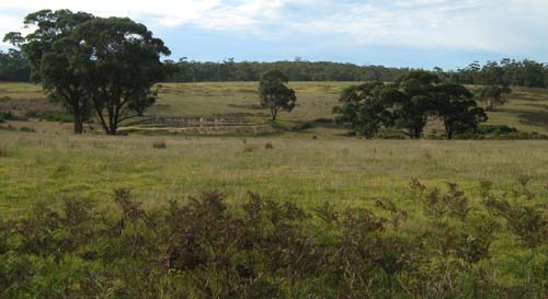
Rolling low hills. In the late Tertiary it is most likely the area was an alluvial plain but since then has been dissected and subject to periods of aridity, resulting in areas of deep sand cover.
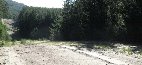
Munro Map unit north-west of Stockdale. These dunes become covered in bracken if the lowland forest is cleared.
Original vegetation
Lowland forest
Soil
The soils of the Munro map unit are deep sands generally with very dark grey acidic sand surface soils overlying paler sands at about 50 cm. These sands may mantle mottled clay but if the sand is sufficiently deep, cemented sands known as ‘coffee rock’ occur in the deeper subsoil, generally around 70 to 90 cm.
Previous maps and reports
This map unit is included within the Stockdale Land System as described by Aldrick et al. (1992).
Land use
Some of the land is cleared, mainly for grazing, but there are large areas of the original vegetation west of the Tambo River and north-west of Lakes Entrance.
These soils may be used for specialised crops (for example, horticulture and floriculture, such as Proteas) if sufficient water is available. As the soils are generally low in organic matter and clay, nutrients will be leached down the soil profile. Wind erosion may also be a problem if the soils are left bare. For crops to be grown, organic matter needs to be maintained or enhanced to improve water retention and regular applications of fertiliser, including dolomitic lime, phosphorus and potassium need to be added.
Site EG220
| Location: Lake Tyers | Geo. Ref.: 0597130E 5813020N |
| Australian Soil Classification: Melacic, Humosesquic, Aeric PODOSOL | Uniform textured deep sand |
| General landscape description: Rolling low hills | |
| Geology: Tertiary sediments | |
| Site description: Simple mid slope 3% north east | |
| Land use: Grazing | |
| Native Vegetation: Lowland forest | |
| Map unit: Stockdale with Munro |
Soil profile morphology
Surface soil
| A1 | 0 – 25 cm | Very dark grey (10YR3/1); sand; apedal, single grain structure; diffuse change to: | 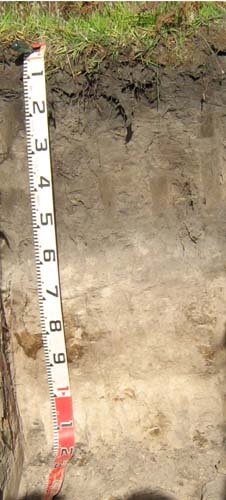 |
| A2 | 25 – 60 cm | Dark grey (10YR4/1); sand; apedal, single grain structure; clear change to: | |
| A3 | 60 – 75 cm | Greyish brown (10YR5/2); sand; apedal, single grain structure; diffuse change to: | |
| Subsoil | |||
| Bhs | 75 – 95 cm | Greyish brown (10YR5/2); sand; apedal, single grain structure; with pockets of a mainly very dark brown (10YR3/2) weakly cemented organic pan; clear change to: | |
| C | 60 – 90 mm | Light brownish grey (10YR6/2); sand; apedal, single grain structure |
Key profile features
- Deep sandy surface.
- Accumulation of iron-organic matter compounds (coffee rock) in the subsoil.
| pH | Salinity rating | Sodicity | Dispersion | Slaking | |
| Surface soil (A1 horizon) | Strongly acid | Very low | Non-sodic | Minimal aggregation | Minimal aggregation |
| Subsurface (A2horizon) | Strongly acid | Very low | Non-sodic | Minimal aggregation | Minimal aggregation |
| Deeper subsoil (70-95 cm) | Moderately acid | Very low | Non-sodic | Minimal aggregation | Minimal aggregation |
| Horizon | Depth cm | Field texture | pH water | pH CaCl2 | EC dS/m | Coarse sand % | Fine sand % | Silt % | Clay % | Field cap. % w/w | Wilt. point % w/w | PAW* water % w/w |
| A1 | 0-25 | S | 5.3 | 4.2 | <0.05 | 69 | 20 | 1 | 2 | 10.6 | 5.4 | 5.2 |
| A2 | 25-60 | S | 5.5 | 4.3 | <0.05 | 68 | 24 | 1 | 2 | 8.4 | 1.5 | 6.9 |
| A3 | 60-75 | S | 5.9 | 4.8 | <0.05 | 64 | 27 | 1 | 3 | 6.7 | 1.2 | 5.5 |
| Bhs | 75-95 | S | 6.0 | 5.0 | <0.05 | 58 | 30 | 4 | 4 | 9.2 | 2.4 | 6.8 |
| Depth | OrgC# | Total N | Free Fe2O3 | Exch. Al | Exchangeable cations cmol (+) /kg | Ca:Mg | ESP | ||||||
| cm | % | % | % w/w | ppm | Ca | Mg | K | Na | Total | H | CEC | ||
| 0-25 | 1.8 | 0.085 | <10 | 2.2 | 0.77 | 0.18 | 0.1 | 3.2 | 7.1 | 10.3 | 2.8 | ||
| 25-60 | 0.66 | <0.05 | 20 | 0.76 | 0.22 | <0.05 | 0.057 | 1.1 | 4.0 | 5.1 | 3.4 | ||
| 60-75 | <0.30 | <0.05 | <10 | 0.55 | 0.38 | <0.05 | 0.077 | 1.1 | 1.4 | 2.5 | 1.4 | ||
| 75-95 | 0.5 | <0.05 | <10 | 1.1 | 1.4 | <0.05 | 0.18 | 2.6 | 4.9 | 7.5 | 0.8 | ||
Management considerations
- If the soil was under pasture with an effective rooting depth of 70 cm the plant available water capacity is considered to be low estimated at 52 mm. Because of the low wilting points throughout the profile, plants will be able to use very light rains when the soil is dry. Due to the low water storage capacity of the soil, plants will suffer water stress unless further rains occur.
- These strongly acid sandy soils have a low nutrient holding capacity and are considered to be infertile. They are naturally deficient in nitrogen, phosphorus, sulphur and potassium. Nitrate and sulphate are readily removed by leaching. Deficiencies of trace elements such as copper, zinc and molybdenum are likely to occur. The trace element boron (B) leaches rapidly through acid sandy soils and deficiencies are also likely to occur.
| Location: Swan Reach | Geo. Ref.: 0579100E 5812700N |
| Australian Soil Classification: Melacic, Humosesquic, Aeric PODOSOL | Uniform textured deep sand |
| General landscape description: Undulating rises | |
| Geology: Tertiary aeolian sediments | |
| Site description: Simple mid slope, N aspect, 8% slope | |
| Land use: Not specified | |
| Map unit: Stockdale with Munro |
Soil profile morphology
Surface soil
| A11 | 0 – 20 cm | Black (10YR2/1); loamy sand; single grain; very weak dry; clear smooth change to: |
A12 | 20 – 45 cm | Very dark grey (10YR3/1); loamy sand; massive; very firm moist; clear wavy change to: |
A2 | 45- 87 cm | Pale brown (10YR6/3) conspicuously bleached (10YR7/2); clayey sand; very firm moist; clear wavy change to: |
Subsoil | ||
Bhs | 87 – 120 cm | Brownish yellow (10YR6/8) with prominent grey mottles; sandy clay loam; weak fine angular blocky structure; very firm moist; clear smooth change to: |
C | 120 – 140 cm | Brownish yellow (10YR6/8); clayey sand; massive; firm moist. |
Key profile features
- Deep sandy profile.
- Leached iron and organic compounds have been precipitated on the sandy clay loam layer below the A horizons.
| Horizon | Depth cm | Field texture | pH water | EC dS/m | Gravel % | Coarse sand % | Fine sand % | Silt % | Clay % | Field cap. % w/w | Wilt. point % w/w | PAW* water % w/w |
| A11 | 0-10 | LS | 5.9 | 0.05 | 4 | 51 | 24 | 7 | 15 | |||
| A12 | 30-45 | LS | 5.2 | <0.05 | 4 | 63 | 24 | 6 | 4 | |||
| A2 | 60-87 | CS | 6.2 | <0.05 | 6 | 65 | 26 | 3 | 8 | |||
| Bhs | 90-115 | LS | 5.8 | 0.17 | 14 | 52 | 19 | 7 | 21 | |||
| C | 120-140 | CS | 5.4 | 0.18 | 16 | 55 | 23 | 8 | 12 |
| Depth | OrgC# | Total N | Free Fe2O3 | Exch. Al | Exchangeable cations cmol(+)/kg | Ca:Mg | ESP | ||||||
| cm | % | % | % w/w | ppm | Ca | Mg | K | Na | Total | H | CEC | ||
| 0-10 | 1.8 | 0.092 | 0.2 | 2.3 | 1.3 | 0.2 | 0.1 | 3.9 | 7.4 | 11.3 | 1.8 | ||
| 30-45 | 0.73 | 0.029 | 0.1 | 0.2 | 0.4 | 0.06 | 0.1 | 0.8 | 5.7 | 6.5 | 0.5 | ||
| 60-87 | 0.13 | 0.006 | 0.1 | <0.01 | 0.15 | 0.03 | 0.05 | 0.23 | 0.83 | 1.06 | |||
| 90-115 | 0.11 | 0.015 | 1.3 | 0.1 | 3.2 | 0.09 | 1.2 | 4.6 | 5.5 | 10.1 | 0.03 | 12 | |
| 120-140 | 0.06 | 0.011 | 1.9 | 0.09 | 2.0 | 0.06 | 1.0 | 3.2 | 3.1 | 6.3 | 0.05 | 16 | |
© State of Victoria (Agriculture Victoria) 1996 - 2025.

This work, Victorian Resources Online, is licensed under a Creative Commons Attribution 4.0 licence. You are free to re-use the work under that licence, on the condition that you credit the State of Victoria (Agriculture Victoria) as author, indicate if changes were made and comply with the other licence terms.
The licence does not apply to ‘branding’ or some ‘images or photographs’ that may be owned by third parties. We ask you to seek prior approval to use images using the VRO feedback form. Access to higher quality images can also be provided on request.
This page was last updated on 23/03/2020.