
Perry (Symbol: Py)
Profile No. 73 (Aldrick et al, 1992) | Sample No. GR25 (Little and Ward)
Geology
Late Pleistocene aeolian sands. As these sands overlie all of the terraces mapped as Fernbank, Briagolong and Stratford they must be geologically younger than these terraces (VandenBerg, 1981). Jenkin (1981) however, regards the raised forms as old levees deposited in a Late Pleistocene delta complex but now capped with aeolian sand. As the most extensive dunefields lie east of the Perry River, both believe the sands were blown from its bed. Ward (1977) has an entirely different explanation. He believes these dunefields to be old stranded fore-dunes and the major breaks in slope former shorelines.
Landform
Longitudinal dunefield. This landform is characterised by long narrow sand dunes and wide flat swales. The dunes are oriented parallel with the direction of the prevailing wind and have side-slopes up to 5%. As most of the dunes and swales occur on the Fernbank terrace, the swales are mapped as Fernbank and the dunes are mapped as Perry.
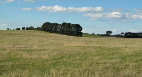
East north eastern trending dune (Perry) and inter-dune swale (Fernbank) near Bengworden
Original vegetation
The dunes formerly supported heathy woodland whereas the swales supported plains grassy woodland.
Soils
On the dunes the depth of sand cover is quite variable, but is eventually underlain by clay. The surface soils are dark grey strongly acidic loamy sands or sands and overlie paler coloured strongly acidic sands. Strongly acidic yellowish brown sand generally occurs before 1 m usually with a zone of iron and organic matter cemented sand called ‘coffee rock’.
The soils in the swales are all texture contrast soils typical of the Fernbank Map unit.
Fernbank and Perry (Symbol: Fe:Py)
This Map unit delineates areas where between about 30% and 70% is either Perry or Fernbank.
Fernbank with Perry (Symbol: Fe/Py)
This Map unit delineates areas where the Perry unit does occur but is less than about 30% of the total area.
Profile No. 73 (Aldrick et al, 1992)
| Location: Providence Ponds | Geo. Ref.: 0525600E 5803300N |
| Australian Soil Classification: Melacic, Humosesquic, Aeric PODOSOL | Uniform deep sand with ‘coffee rock’ |
| General landscape description: Dunefield | |
| Geology: Aeolian sand | |
| Site description: 3% slope | |
| Land use: Unused | |
| Native vegetation: Heathy woodland | |
| Map unit: Perry |

Road exposure near the profile described below
Soil profile morphology
Surface soil
| A1 | 0 – 22 cm | Very dark grey (10YR3/1); sand; single grain; soft consistence, dry; abrupt wavy change to: |
| A2 | 22 – 75 cm | Greyish brown (10YR5/2); sand; single grain; loose dry; clear wavy change to: |
| B2ir | 75 – 110 cm | Yellowish brown (10YR5/8); sand; single grain; loose dry; gradual change to: |
| B3 | 110 – 150 cm | Brownish yellow (10YR6/6); loamy sand; single grain; soft dry; clear change to: |
| 11B2ir | 150 – 297 cm | Brownish yellow (10YR6/6); loamy sand; single grain; 20 % ferruginous nodules up to 20 mm, increasing up to 40 mm. |
Key profile features
- Sand textures throughout the profile.
- Presence of iron/organic matter nodules at depth.
| Horizon | Depth cm | Field texture | pH water | EC dS/m | Gravel % | Coarse sand % | Fine sand % | Silt % | Clay % | Field cap. % w/w | Wilt. point % w/w | PAW* water % w/w |
| A1 | 0-10 | S | 5.2 | 0.02 | 0 | 36 | 58 | 3 | 4 | |||
| A2 | 22-30 | S | 4.6 | <0.01 | 0 | 37 | 61 | 1 | 1 | |||
| A2 | 60-75 | S | 4.9 | <0.01 | 0 | 36 | 62 | 1 | 1 | |||
| B2ir | 75-90 | S | 5.1 | 0.01 | 0 | 29 | 66 | 2 | 3 | |||
| B3 | 110-120 | S | 5.7 | <0.01 | 0 | 30 | 68 | <1 | 2 |
| Depth | Org C | Total N | Free Fe2O3 | Exch. Al | Exchangeable cations cmol(+)/kg | Ca:Mg | ESP | ||||||
| cm | % | % | % w/w | ppm | Ca | Mg | K | Na | Total | H | CEC | ||
| 0-10 | 1.02 | 0.05 | 0.2 | 1.4 | 0.05 | 0.1 | 0.1 | 3.6 | 5.8 | ||||
| 22-30 | 0.25 | 0.02 | 0.1 | 0.3 | 0.1 | 0.05 | 0.03 | 1.4 | 1.9 | ||||
| 60-75 | 0.07 | 0.01 | 0.2 | 0.2 | 0.01 | 0.02 | 0.09 | 0.2 | 0.6 | ||||
| 75-90 | 0.23 | 0.01 | 0.6 | 0.3 | 0.01 | 0.06 | 0.04 | 3.2 | 3.7 | ||||
| 110-120 | 0.3 | 0.3 | 0.01 | 0.4 | 0.03 | 2.3 | 2.8 | ||||||
Whole profile
- Plant available water capacity (PAWC) would be very low but can be increased by additional organic matter.
- A major advantage of these soils is they usually drain very well and can be worked throughout the year.
- Sandy soils are extremely prone to wind erosion following vegetation removal.
- As the soils are sandy and would have a low wilting point, plants will be able to utilise light rains falling on dry soil. However, due to the low water storage capacity, plants will soon suffer moisture stress unless further rainfall occurs. Organic matter is important in these sandy soils to enhance both water and nutrient holding capacity.
- The soil is strongly acid and a response to lime would be expected. Test strips should be used to evaluate the likely cost/benefit analysis. Benefits of liming include increased molybdenum availability, but it may make trace elements such as boron, zinc and manganese less available. Foliar analysis is advised where trace element deficiencies are suspected.
- The sandy surface soil will be prone to wind erosion if plant cover is removed and blow-outs can occur.
- The surface soil has an extremely low inherent fertility (based on the sum of the exchangeable cations). Such strongly leached soils are also likely to be naturally deficient in nitrogen, phosphorus, sulphur and potassium.
- The surface soil is extremely deficient in potassium and a response to potassium fertiliser would be expected.
- Regular fertiliser inputs are required for intensive cropping. Nitrate and sulphate are readily soluble and easily removed by leaching. More regular but smaller applications of fertiliser will assist in reducing loss of nutrients through leaching. Nutrients lost through leaching may influence catchment water quality.
- The ‘coffee rock’ layer may restrict the downward movement of plant roots and water. In some situations, the temporary build up of water on top of this less permeable layer may be beneficial for deeper rooted plants as it prevents deep drainage of water away from plant roots.
| Location: Willis La., Meerlieu | Geo. Ref.: 531300E 5793400N |
| Australian Soil Classification: Eutrophic (and Magnesic), Mottled-Mesonatric, Brown SODOSOL (Very thick sandy) | Deep sandy brown sodic texture contrast soil |
| Map unit: Perry |
| Depth cm | Colour | Texture | pH | TSS % | Grv % | CS % | FS % | Silt % | Clay % | Org C % | Tot N % | Exchangeable cations cmol(+)/kg | Ca:Mg | ESP | ||||
| Ca | Mg | K | Na | CEC | ||||||||||||||
| 0-10 | Grey | LS | 5.8 | 0.02 | 1.2 | 0.05 | 1.6 | 0.45 | 0.11 | 0 | 5.0 | 3.6 | 0 | |||||
| 70-90 | Mottled yellowish brown and yellow brown | SCL | 6.9 | 0.05 | 29 | 32 | 2 | 38 | 0.61 | 6.3 | 0.08 | 2.2 | 12.4 | 0.1 | 18 | |||
| 135-150 | Mottled grey, strong brown and reddish brown | SC | 6.7 | 0.10 | 20 | 29 | 5 | 45 | 0.55 | 9.0 | 0.12 | 3.6 | 15.8 | <0.1 | 23 | |||
Note: The grey sand surface soil extended to a depth of 70cm.
© State of Victoria (Agriculture Victoria) 1996 - .

This work, Victorian Resources Online, is licensed under a Creative Commons Attribution 4.0 licence. You are free to re-use the work under that licence, on the condition that you credit the State of Victoria (Agriculture Victoria) as author, indicate if changes were made and comply with the other licence terms.
The licence does not apply to ‘branding’ or some ‘images or photographs’ that may be owned by third parties. We ask you to seek prior approval to use images using the VRO feedback form. Access to higher quality images can also be provided on request.
This page was last updated on .