
Fernbank (Symbol: Fe)
EG254 | EG210 | EG255 | EG256 | GP83 | Profile No. 68 | Sample No. GR3 | Sample No. GR5 | Sample No. GR6 | Sample No. GR10 | Sample No. GR11 | Sample No. GR13 | Sample No. GR14 | Sample No. GR17 | Sample No. GR26 | Sample No. GR30
Geology
Pleistocene alluvial sediments. Referred to on the geological maps as Qp2, and regarded as being the second oldest of six alluvial terraces deposited during the Pleistocene.
Landform
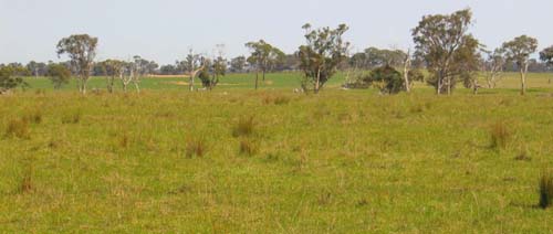
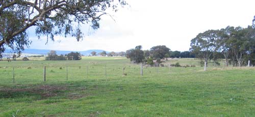
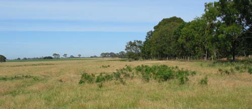
This unit forms the most extensive landform along the Princes Highway between Stratford and Paynesville and may be described as a weakly dissected undulating plain. It has an even SSE slope of about 1 in 200, with a maximum elevation of about 160 metres near Briagolong and 125 metres at The Fingerboards, and a minimum elevation of 20–25 metres at its southern margin. A considerable period of time has elapsed since this terrace was deposited and weak dissection has occurred along the margins of drainage lines, for example on either side of Tom’s Creek. Some deposition of material from higher in the landscape has added to the complexity of the pattern of soils. Sand dunes mantle extensive areas of this terrace, particularly immediately east of the Perry River. The soils on these dunes are described under the map unit ‘Perry’. It is likely there have been several episodes of sand dune formation, each episode corresponding to a particular glacial cycle.
An interactive visualisation of the landscape in the Fernbank mapping unit is provided here. Zooming and panning functionality is provided as well as the ability to click on icons to provide further information about the landscape (e.g. soils, geology).
We've detected that the 'Flash Player' installed is either missing or not fully up-to-date and cannot play the content we've created.

For the best viewing experience please click on the icon above to install Adobe's Latest Flash Player.
Photo | Panoroma | Information | Soil pit | Video |
Use your keyboard and mouse to navigate the study area. To zoom in or out, left mouse click inside the panorama and use the mouse's 'scroll wheel' (if you have one) or press and hold 'Shift' or 'Ctrl'. To explore the landscape, click and hold the left mouse button on the landscape and move the mouse left, right, up or down or use 'cursor keys'.
The interactive landscapes is 4 MB in size, this might take some time to automatically download if you're using a slow internet connection. If you experience any problems you should update the 'Adobe Flash Player' used. This software can be downloaded for free from the Adobe website (external link).
| Original vegetation Plains grassy woodland. Where sands mantle the plain, the vegetation was heathy woodland. Soils All the soils are texture contrast soils. The surface soils are strongly to moderately acidic and range from dark greyish brown clay loams to sands and invariably have a bleached subsurface soil. Many of the surface soils are stony. Sodic and coarsely structured medium to heavy clays occur at a variable depth, generally before 50 cm, typically yellowish brown with grey or strong brown mottles. In areas where the Perry map unit also occurs, a mantle of sand overlies the clay. If the sand is sufficiently deep, ‘coffee rock’ occurs in the subsoil. Previous maps and reports This map unit was mapped under the Redgum 1 and Redgum 2 Land System by Aldrick et al (1992). Land use Most of the land is cleared, mainly for grazing, but there are remnants of the original vegetation west of the Bairnsdale airport. | 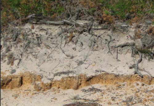 Sandy soils of the Perry map unit east of the Providence Ponds. The cemented brown sands at about 80 cm in the subsoil are often referred to as ‘coffee rock’. |
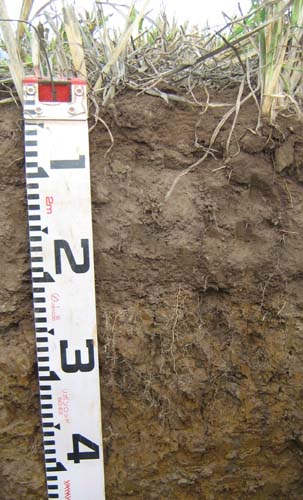
Site EG254
| Location: Banksia Peninsula | |
| Australian Soil Classification: Magnesic, Subnatric, Brown SODOSOL | |
| General landscape description: Undulating Rises | |
| Geology: Pleistocene alluvial sediments | |
| Site description: SE aspect, 7% slope | |
| Vegetation: Plains grassy woodland | |
| Map unit: Fernbank |
Soil profile morphology
Surface soil
| A11 | 0 – 10 cm | Very dark grey (7.5YR3/1); loamy sand; weak fine subangular blocky structure; firm consistence dry; clear change to: |  |
| A12 | 10 – 35 cm | Very dark grey (7.5YR2/1); loamy sand; abundant (50-90%) medium (6-20 mm) rounded quartz and sandstone pebbles; firm consistence, dry; gradual change to: | |
| A2 | 35 – 50/60 cm | Brown (10YR5/3) conspicuously bleached very pale brown (10YR7/3d); sandy loam; massive, abrupt wavy change to: | |
| Subsoil | |||
| B21 | 50/60 – 110 cm | Brown (7.5YR4/4) with grey mottles; light medium clay; weak medium angular blocky structure; strong consistence dry; gradual change to: | |
| B22 | 110 – 180 cm | Yellowish brown (10YR5/8) with few coarse (15-30 mm) grey (10YR5/1) mottles; sandy clay; massive; clear change to: | |
| C1 | 180 – 240 cm | White (2.5Y8/1) with common (10-20%) prominent fine medium (5-15 mm) dark yellowish brown (10YR4/4) mottles; light clay; firm consistence moderately moist. |
Key profile features
- Strong texture contrast between the sandy top soil and the clay subsoil.
| pH | Sodicity | Slaking | Dispersion Dry | Dispersion Remoulded | |
| Surface soil (A11 horizon) | Strongly acid | Non-sodic | Minimal aggregation | Nil (2 hours), Nil (20 hours) | Slight 2 hours), Slight (20 hours) |
| Subsurface (A2 horizon) | Moderately acid | Non-sodic | Considerable | Slight (2 hours), Moderate (20 hours) | Strong (2 hours), Strong (20 hours) |
| Subsoil (B21 horizon) | Moderately acid | Sodic | Considerable | Moderate (2 hours), Moderate (20 hours) | Strong (2 hours), Strong (20 hours) |
| Horizon | Depth cm | Texture | pH water | pH CaCl2 | EC dS/m | Coarse sand % | Fine sand % | Silt % | Clay % | Field cap. w/w | Wilt. point % w/w | PAW* water %w/w |
| A11 | 0-10 | LS | 5.5 | 4.5 | 0.19 | 54 | 24 | 8 | 5 | 25.3 | 10.0 | 15.3 |
| A12 | 10-35 | SL | 5.6 | 4.7 | 0.06 | 54 | 26 | 11 | 6 | 17.9 | 4.6 | 13.6 |
| A2 | 35-52 | SL | 6.0 | 5.0 | 0.08 | 53 | 22 | 12 | 12 | 12.5 | 5.1 | 7.4 |
| B21 | 52-110 | LMC | 5.6 | 4.6 | 0.32 | 46 | 10 | 5 | 36 | 25.5 | 14.4 | 11.1 |
| B22 | 110-180 | SC | 5.4 | 4.7 | 0.40 | 54 | 13 | 3 | 32 | 22.1 | 11.1 | 11.0 |
| C1 | 180-240 | 5.5 | 4.8 | 0.78 | 0.4 | 8 | 50 | 37.5 | 38.3 | 20.2 | 18.1 |
| Depth | OrgC# | Total N | Free Fe2O3 | ExchAl | Exchangeable cations cmol(+)/kg | Ca:Mg | ESP | ||||||
| cm | % | % | % w/w | ppm | Ca | Mg | K | Na | Total | H | CEC | ||
| 0-10 | 4.8 | 0.36 | 45 | 4.4 | 1.0 | 0.9 | <0.1 | 6.3 | 12 | 18.3 | 4.0 | ||
| 10-35 | 1.7 | 0.09 | 56 | 1.6 | 1.5 | <0.1 | <0.1 | 3.1 | 8.9 | 12 | 1.1 | ||
| 35-52 | 16 | 0.4 | 1.9 | <0.1 | 0.2 | 2.5 | 3.5 | 6 | 0.2 | 3 | |||
| 52-110 | 8 | <0.1 | 3.2 | <0.1 | 0.8 | 4.0 | 5.8 | 9.8 | <0.03 | 8 | |||
| 110-180 | 13 | <0.1 | 3.0 | <0.1 | 1.0 | 4.0 | 4 | 8 | <0.03 | 13 | |||
| 180-240 | 14 | <0.1 | 6.8 | 0.3 | 2.9 | 10 | 4.8 | 14.8 | <0.03 | 20 | |||
Management considerations
Whole profile
- Plant available water is considered to be very low (estimated at 28 mm) for this profile based on an effective rooting depth of 52 cm. The presence of large amounts of pebbles in the A horizon and the dense clayey subsoil greatly reduce water retention.
- The surface soil is moderately acidic and, because it is also moderately high in aluminium, lime application may be of benefit.
- Potassium levels in the surface soil are high, but below the surface soil it is at deficiency level.
- The surface horizons have a low nutrient holding capacity (based on the sum of exchangeable calcium, magnesium, potassium and sodium). Organic matter is important for maintaining nutrient and water holding capacity, especially in sandy soils.
- The low wilting points of the surface soils indicates plants will be able to use very light rains when the soil is dry. Due to the low water storage capacity of the surface soils, plants will soon suffer moisture stress unless follow-up rains occur.
- The depth to the clay would have little influence on plant growth as it occurs too deep in the profile.
Site EG210
| Location: SFS Trial site, Bengworden | Geo. Ref.: 549000E 5805800N |
| Australian Soil Classification: Vertic (and Magnesic), Brown SODOSOL | Brown sodic texture contrast soil |
| General landscape description: Level plain | |
| Geology: Pleistocene alluvium (Qp2) | |
| Site description: Level, slope <1 % | |
| Land use: Millet | |
| Native Vegetation: Plains grassy woodland | |
| Map unit: Fernbank |
Soil profile morphology
Surface soil
| A1 | 0 – 10 cm | Dark brown (10YR3/3); sandy loam; weak fine granular structure; very weak consistence moist; clear change to: |  |
| A2 | 10 – 10/30 cm | Brown (10YR5/3), conspicuously bleached (10YR7/2d); loamy sand; apedal; weak consistence dry; sharp wavy change to: | |
| Subsoil | |||
| B21 | 10/30 – 50 cm | Yellowish brown (10YR5/6); medium to heavy clay; strong coarse columnar structure parting to strong fine polyhedral structure; very firm moist; diffuse change to: | |
| B22 | 50 – 75 cm | Dark yellowish brown (10YR4/6) distinct red (2.5YR4/6) mottles; medium to heavy clay; moderate coarse lenticular structure; very firm moist; diffuse change to: | |
| B23 | 75 – 120 cm | Mottled brown (10YR5/3) and red (2.5YR4/6); medium to heavy clay; moderate coarse lenticular structure; very firm moist | |
- Strong texture contrast between the surface horizons (A1 and A2) and the subsoil horizons (B)
- Bleached subsurface soil
- Lenticular structure in the deep subsoil, indicating swelling and shrinking between wet and dry conditions.
| pH | Sodicity | Slaking | Dispersion Dry | Dispersion Remoulded | |
| Surface soil (A1 horizon) | Moderately acidic | Non sodic | Water stable | Nil (2 hours), Nil (20 hours) | Nil (2 hours), Slight (20 hours) |
| Subsoil (B21 horizon) | Moderately acidic | Sodic | Partial | Nil (2 hours), Nil (20 hours) | Strong (2 hours), Complete (20 hours) |
| Deeper subsoil (75-120 cm) | Moderately acidic | Strongly sodic | Considerable | Nil (2 hours), Nil (20 hours) | Nil (2 hours), Nil (20 hours) |
| Horizon | Depth cm | Field texture | pH water | pH CaCl2 | EC dS/m | Coarse sand % | Fine sand % | Silt % | Clay % | Field cap. % w/w | Wilt. point % w/w | PAW* water % w/w |
| A1 | 0-10 | SL | 5.8 | 5.2 | 0.17 | 23 | 44 | 14 | 13 | 18.3 | 7.3 | 11.0 |
| A2 | 10+/30 | LS | 5.7 | 4.6 | <0.05 | 28 | 45 | 16 | 6 | 15.9 | 4.3 | 11.6 |
| B21 | 10/30-50 | MHC | 5.9 | 4.7 | 0.08 | 7 | 13 | 7 | 69 | 42.6 | 26.4 | 16.2 |
| B22 | 50-75 | MHC | 5.9 | 4.8 | 0.15 | 4.6 | 9.7 | 9 | 72 | 46.4 | 27.7 | 18.7 |
| B23 | 75-120 | MHC | 5.6 | 4.7 | 0.23 | 8.4 | 17.3 | 10 | 62 | 37.1 | 20.5 | 16.6 |
| Depth | OrgC# | Total N | Free Fe2O3 | Exch. Al | Exchangeable cations cmol(+)/kg | Ca:Mg | ESP | ||||||
| Cm | % | % | % w/w | ppm | Ca | Mg | K | Na | Total | H | CEC | ||
| 0-10 | 2.1 | <0.05 | <10 | 4.4 | 1.9 | 0.34 | 0.36 | 7.0 | 5.9 | 12.9 | 2.2 | 3 | |
| 10+/30 (A2) | 1.0 | 0.063 | 11 | 1.1 | 0.84 | 0.075 | 0.18 | 2.2 | 4.4 | 6.6 | 1.3 | 3 | |
| 10/30-50 | 0.89 | <0.05 | 100 | 2.2 | 9.3 | 0.2 | 1.6 | 13.3 | 12 | 25.3 | 0.2 | 6 | |
| 50-75 | 0.61 | <0.05 | 84 | 1.1 | 11 | 0.24 | 2.4 | 14.7 | 11 | 25.7 | 0.1 | 9 | |
| 75-120 | 0.38 | <0.05 | 99 | 0.3 | 8.2 | 0.14 | 3.3 | 12.0 | 8.9 | 20.9 | 0.04 | 17 | |
Management considerations
Whole profile
|  Effective root penetration to about 35 mm |
Site EG255
| Location: Fernbank (Tom’s Creek flood plain) | Geo. Ref.: 532200E 5804000N |
| Australian Soil Classification: Mesotrophic, Mottled-Subnatric,Brown SODOSOL | Brown sodic texture contrast soil (deep surface) |
| General landscape description: Meander plain | |
| Geology: Neogene alluvial sediments | |
| Site description: Level | |
| Native Vegetation: Plains grassy woodland | |
| Map unit: Fernbank |
Soil profile morphology
Surface soil
| 1A11 | 0-30 cm | Greyish brown (2.5Y5/2); loamy sand; massive; clear change to: |  |
| 1A12 | 30-65 cm | Dark grey (10YR4/2); loamy coarse sand; massive, loose to very weak consistence moist; abundant (50-90%) rounded quartz pebbles (20-60 mm); clear change to: | |
| 1A21 | 65- 85/90 cm | Yellowish brown (10YR5/4); coarse sand; massive; sharp wavy change to: | |
| 2A22 | 85/90-100/110 cm | Light grey; sandy loam; massive; sharp tongued boundary to: | |
| Subsoil | |||
| 2B2 | 100 /110 – 180 cm | Greyish brown (2.5Y5/2) with common (10-20%) medium (5-15 mm) yellowish brown (10YR5/6) mottles; light medium clay; strong very coarse columnar structure, strongly parting to medium angular blocky; strong consistence dry; few (2-10%) large (20-60 mm) rounded quartz pebbles; diffuse change to: | |
| 2C | 180 – 270 cm | Brown (10YR5/3) with few (2-10%) faint coarse (15-30 mm) yellowish brown mottles; coarse sandy clay loam; massive; abundant (50-90%) large (20-60 mm) rounded quartz pebbles |
Key profile features
- Strong texture contrast between the sandy top soil and the medium heavy clay subsoil
- The surface 70 cm layer appears to have been deposited at a different period to the underlying layers.
| pH | Sodicity | Slaking | Dispersion Dry | Dispersion Remoulded | |
| Sub-surface (A11 horizon) | Strongly acidic | Non sodic | Minimal aggregation | Minimal aggregation | Minimal aggregation |
| (2A2 horizon) | Strongly acidic | Non sodic | Minimal aggregation | Minimal aggregation | Minimal aggregation |
| Subsoil 110-180 cm | Moderately acidic | Sodic | Considerable | Strongly dispersive | Slakes considerably |
| Horizon | Depth cm | Texture | pH water | pH CaCl2 | EC dS/m | Coarse sand % | Fine sand % | Silt % | Clay % | Field cap. w/w | Wilt. point % w/w | PAW* water %w/w |
| A11 | 0-30 | S | 6.6 | 1.9 | 4.7 | |||||||
| A12 | 30-65 | S | 5.1 | 4.4 | <0.05 | 31 | 62 | 3 | 3 | 7 | 2.8 | 4.2 |
| A2 | 65-90 | S | 5.2 | 4.4 | <0.05 | 62 | 27 | 3 | 4 | 5.6 | 1.4 | 4.2 |
| 2A21 | 90-100 | S | 5.4 | 4.7 | <0.05 | 55 | 39 | 3 | 2 | 9.5 | 4 | 5.5 |
| 2A22 | 100-110 | SL | 5.9 | 4.6 | <0.05 | 44 | 36 | 10 | 10 | 9.5 | 4 | 5.5 |
| 2B2 | 110-180 | MHC | 5.7 | 4.3 | 0.08 | 26 | 22 | 4 | 46 | 30.2 | 18.4 | 11.8 |
| 2C | 180-270 | 5.8 | 4.5 | 0.08 | 55 | 23 | 4 | 17 | 13.5 | 7.1 | 6.4 |
| Depth | OrgC# | Total N | Free Fe2O3 | Exch. Al | Exchangeable cations cmol(+)/kg | Ca:Mg | ESP | ||||||
| cm | % | % | % w/w | ppm | Ca | Mg | K | Na | Total | H | CEC | ||
| 0-30 | 0.7 | <0.05 | |||||||||||
| 30-60 | 0.8 | <0.05 | 14 | 0.5 | 0.3 | <0.1 | <0.1 | 0.8 | 2.1 | 2.9 | 1.7 | ||
| 65-85/90 | 0.3 | <0.05 | 36 | 0.2 | 0.4 | <0.1 | <0.1 | 0.6 | 3 | 3.6 | 0.5 | ||
| 85/90-100 | 7 | <0.1 | 0.1 | <0.1 | <0.1 | 0.1 | 1.1 | 1.2 | |||||
| 100-110 | 6 | <0.1 | 0.8 | <0.1 | <0.1 | 0.8 | 1.5 | 2.3 | |||||
| 110-180 | 110 | <0.1 | 5.0 | 0.1 | 1.1 | 6.1 | 9 | 15.1 | 7 | ||||
| 180-270 | 15 | <0.01 | 2.7 | 0.1 | 0.8 | 3.6 | 3.3 | 6.9 | 12 | ||||
Management considerations
Whole profile
- Plant available water is considered to be very low (estimated at 44 mm) for this profile based on an effective rooting depth of 65 mm.
- The surface soil is strongly acid and it would be expected liming may improve plant growth.
- Potassium is extremely deficient and a strong response to potassium fertiliser would be expected, provided phosphate was also added.
- The surface horizons have an extremely low nutrient holding capacity. Organic matter is important for maintaining nutrient and water holding capacity, especially in sandy soils.
- The low wilting points of the surface soils indicates plants will be able to use very light rains when the soil is dry. Due to the low water storage capacity of the surface soils, plants will soon suffer moisture stress unless follow-up rains occur.
- The depth to the clay would have little influence on plant growth as it occurs too deep in the profile.
Site EG256
| Location: Fingerboards | Geo. Ref.: 528900E, 5817000N |
| Australian Soil Classification: Eutrophic, Mottled-Subnatric, Brown SODOSOL | Sodic brown texture contrast soil |
| General landscape description: Undulating Rises | |
| Geology: Neogene alluvial sediments | |
| Site description: North Slope of low rise (4%) | |
| Native Vegetation: Plains grassy woodland | |
| Map unit: Fernbank |
Soil profile morphology
Surface soil
| A1 | 0-15 cm | Very dark greyish brown (2.5YR3/2); loamy sand; moderate fine to medium sub-angular blocky structure; very weak consistence moderately moist; clear and smooth change to: | 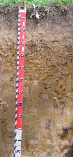 |
| A2 | 15-27 cm | Pale brown (10YR6/3), light grey (10YR7/2) dry; sand; massive, loose to very weak consistence moist; very few fine quartz gravel; abrupt and wavy change to: | |
| Subsoil | |||
| B21 | 27-90cm | Yellowish brown (10YR5/4) with many coarse distinct strong brown (5YR5/8) mottles; heavy clay; weak very coarse columnar structure parting to moderate medium; to coarse prismatic structure; firm consistence moist; diffuse change to: | |
| B22 | 90-120cm | Yellowish brown (10YR5/4) with common medium distinct grey and red mottles; heavy clay; weak medium prismatic structure; very firm consistence moderately moist. |
Key profile features
- Strong texture contrast between the surface horizons (A1 and A2) and the subsoils (B horizons).
- Conspicuously bleached subsurface (A2) horizon.
| pH | Sodicity | Slaking | Dispersion Dry | Dispersion Remoulded | |
| Surface (A1 horizon) | Moderately acidic | Non sodic | Water stable | Nil (2 hours), Nil (20 hours) | Nil (2 hours), Nil (20 hours) |
| Subsoil (B21 horizon) | Slightly acidic | Sodic | Partial | Strong (2 hours), Strong (20 hours) | Strong (2 hours), Complete (20 hours) |
| Deep subsoil 90 – 120 cm | Moderately alkaline | Strongly sodic | Considerable | Moderate (2 hours), Strong (20 hours) | Moderate (2 hours), Complete (20 hours) |
| Horizon | Depth cm | Field texture | pH water | pH CaCl2 | EC dS/m | Coarse sand % | Fine sand % | Silt % | Clay % | Field cap. % w/w | Wilt. point % w/w | PAW* water % w/w |
| A1 | 0-15 | LS | 5.7 | 4.5 | 0.19 | 37 | 39 | 7 | 10 | 20.4 | 6.9 | 13.5 |
| A2 | 15-27 | S | 6.0 | 4.5 | <0.05 | 39 | 43 | 7 | 11 | 11.3 | 1.8 | 9.5 |
| B21 | 27-90 | MC | 6.6 | 6.4 | 0.19 | 20 | 27 | 9 | 42 | 26.9 | 15.3 | 11.6 |
| B22 | 90-120 | HC | 8.0 | 7.2 | 0.35 | 18 | 26 | 11 | 43 | 23.4 | 13.0 | 10.4 |
| Depth | OrgC# | Total N | Free Fe2O3 | Exch. Al | Exchangeable cations cmol(+)/kg | Ca:Mg | ESP | ||||||
| cm | % | % | % w/w | ppm | Ca | Mg | K | Na | Total | H | CEC | ||
| 0-15 | 3.6 | 0.36 | 4.6 | 1.3 | 0.81 | 0.44 | 7.2 | 12 | 19.2 | 3.5 | |||
| 15-27 | 0.85 | 0.36 | 0.24 | 0.11 | 1.6 | 4.3 | 5.9 | 2.4 | |||||
| 27-90 | 1.7 | 8.2 | 0.62 | 1.8 | 12.3 | 4.9 | 17.1 | 0.2 | 11 | ||||
| 90-120 | 0.5 | 8.7 | 0.3 | 2.8 | 12.3 | 12.3 | 0.06 | 23 | |||||
Management considerations
Whole profile
- Plant available water is considered to be very low (estimated at 47 mm) for this profile based on an effective rooting depth of 35 mm. The dense and coarsely structured upper subsoil is likely to restrict root depth. Most of the plant available water will be in the A1 horizon as the A2 horizon will be seasonally saturated. Roots in the subsoil will be confined to cracks in the soil and not penetrate deeply.
- The surface soil is moderately acid but is highly unlikely to affect plant growth.
- Potassium levels are high and no response to added potassium is likely.
- The surface (A1) horizon has a low nutrient holding capacity. Organic matter is important for maintaining nutrient and water holding capacity, especially in sandy soils
- The low wilting points of the surface soils indicates plants will be able to use very light rains when the soil is dry. Due to the low water storage capacity of the surface soils, plants will soon suffer moisture stress unless follow-up rains occur.
- The dense and coarsely structured subsoil is sodic and is strongly dispersive. This will result in significantly restricted root and water movement. The use of gypsum in association with deep ripping has been advocated by some researchers as an effective way to ameliorate sodic subsoils.
Site GP83
| Location: Fernbank | Geo. Ref.: 516100E 5803200N |
| Australian Soil Classification: Vertic, Mottled-Subnatric, Brown SODOSOL | Sodic brown texture contrast soil |
| General landscape description: Undulating plain with low rises | |
| Geology: Quaternary (Pleistocene) sediments | |
| Site description: Grazing paddock | |
| Map unit: Fernbank |
Soil profile morphology
Surface soil
| A1 | 0-15 cm | Dark brown (10YR3/3); loamy sand; pH 4.9; clear change to: | 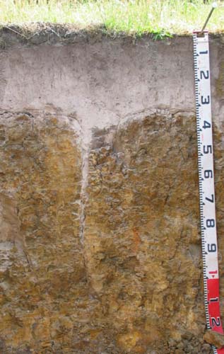 |
| A2 | 15-30 cm | Light yellowish brown (10YR6/4) conspicuously bleached (10YR8/1 dry) mottles; sand; pH 5.1; sharp change to: | |
| Subsoil | |||
| B21 | 30-60 cm | Yellowish brown (10YR5/6) with brownish yellow (10YR6/8) and greyish brown (10YR5/2) mottles; medium heavy clay; strong very coarse columnar, parting to weak-moderate very coarse blocky and weak coarse polyhedral structure; strong consistence (dry); pH 6.3; gradual change to: | |
| B22 | 60-100 cm | Brownish yellow (10YR6/6, 6/8); light medium clay (sandy); strong very coarse prismatic structure; isolated rounded quartz gravel (5 cm); isolated slickensides; pH 7.0; gradual change to: | |
| B23 | 100-120+ cm | Yellowish brown (10YR5/6); medium clay (sandy); moderate coarse prismatic, parting to moderate coarse blocky structure; dark staining evident; contains few (10%) quartz grit; pH 7.3. | |
- Strong texture contrast between sandy surface (A) horizons and clayey subsoil (B21) horizon.
- Conspicuously bleached subsurface (A2) horizon.
| Horizon | pH | Salinity rating | Sodicity | Dispersion |
| Surface (A1 horizon) | Very Strongly Acid | Very Low | Non-Sodic | None |
| Subsoil (B21 horizon) | Slightly Acid | Low | Sodic | Strong |
| Deeper subsoil (at 100-120+ cm) | Slightly Alkaline | Medium | Strongly Sodic | Slight - Moderate |
| Horizon | Depth cm | Field texture | pH water | pH CaCl2 | EC dS/m | Coarse sand % | Fine sand % | Silt % | Clay % | Field cap. % w/w | Wilt. point % w/w | PAW* water % w/w |
| A1 | 0-15 | LS | 4.9 | 4.3 | 0.08 | 50 | 32 | 9 | 4 | 10.5 | 3.9 | 7 |
| A2 | 15-30 | S | 5.1 | 4.5 | <0.05 | 50 | 37 | 8 | 2 | 6.7 | 1.3 | 6 |
| B21 | 30-60 | MHC | 6.3 | 5.2 | 0.11 | 23 | 18 | 8 | 50 | 29.0 | 17.7 | 11 |
| B22 | 60-100 | LMC | 7.0 | 6.1 | 0.16 | 24 | 21 | 9 | 48 | 27.7 | ||
| B23 | 100-120+ | MC | 7.3 | 6.7 | 0.58 | 9 | 30 | 18 | 42 | 17.2 | 15.4 | 2 |
| Depth | OrgC# | Total N | Free Fe2O3 | Exch. Al | Exchangeable cations cmol(+)/kg | Ca:Mg | ESP | ||||||
| cm | % | % | % w/w | ppm | Ca | Mg | K | Na | Total | H | CEC | ||
| 0-15 | 26 | 1.5 | 0.41 | 0.07 | 0.28 | 2.3 | 7.7 | 10 | 3.7 | ||||
| 15-30 | 13 | 0.35 | 0.10 | <0.05 | 0.21 | 0.7 | 1.1 | 1.8 | 3.5 | ||||
| 30-60 | 12 | 2.1 | 6.1 | 0.14 | 1.7 | 10 | 7.4 | 17.4 | 0.34 | 10 | |||
| 60-100 | 0.98 | 7.3 | 0.13 | 2.6 | 11 | 11 | 0.13 | 24 | |||||
| 100-120+ | 0.7 | 7.3 | 0.1 | 3.7 | 11.8 | 11.8 | 0.1 | 31 | |||||
Management considerations
Surface (A) horizons
- The sandy surface horizons have a low water storage capacity. The low wilting point values indicate plants will be able to utilise light rains falling on relatively dry soils. However, due to the low water storage capacity, plants will soon suffer moisture stress unless further rainfall occurs. Organic matter is important in these sandy soils to enhance water holding capacity – as well as to enhance aggregation and fertility. These sandy soils have a low inherent fertility and are very strongly acid. Such strongly leached soils are also likely to be naturally deficient in nitrogen, phosphorus, sulphur and potassium. Lime application will result in increased pH levels and make certain nutrients such as phosphorus more available to plants. Deficiencies of the trace element molybdenum (Mo) are also likely to occur in acid sandy soils (soil adsorption of Mo increases as pH decreases, leading to reduced availability to plants).
- The dense and coarsely structured upper subsoil is sodic and strongly dispersive. This will result in restricted root and water movement into the subsoil. After heavy rains water is likely to build up on top of the subsoil – leading to potential waterlogging in the sandy surface horizons.
Profile No. 68 (Aldrick et al, 1992)
| Location: 24 km East of Stratford | Geo. Ref.: 531300E 5795800N |
| Australian Soil Classification: Eutrophic, Mottled-Mesonatric, Brown SODOSOL | Sodic brown texture contrast soil |
| Map unit: Fernbank |
| Depth cm | Colour | Texture | pH | TSS % | Grv % | CS % | FS % | Silt % | Clay % | Org C % | Tot N % | Exchangeable cations cmol(+)/kg | Ca:Mg | ESP | ||||
| Ca | Mg | K | Na | CEC | ||||||||||||||
| 0-10 | Very dark grey | LS | 5.9 | 0.01 | 2 | 45 | 42 | 5 | 4 | 1.1 | 0.09 | 1.1 | 0.5 | 0.2 | 0.08 | 6.7 | 2.2 | 1 |
| 10-20 | Dark greyish brown | S | 6.2 | 0.01 | 7 | 47 | 42 | 5 | 4 | . | 0.8 | 0.3 | 0.06 | 0.06 | 3.5 | 2.7 | 2 | |
| 30-60 | Yellowish brown with grey mottles | SC | 7.2 | 0.05 | 14 | 27 | 32 | 4 | 35 | 0.4 | 5.5 | 0.09 | 2.5 | 14.1 | 0.7 | 18 | ||
| 90-120 | Yellowish brown with grey mottles | SC | 7.7 | 0.11 | 19 | 20 | 29 | 4 | 44 | 0.2 | 7.3 | 0.09 | 4.9 | 17.2 | 0.3 | 28 | ||
Sample No. GR3 (Little and Ward)
| Location: Centre Goon Nure Road, Goon Nure | Geo. Ref.: 549600E 5799400N |
| Australian Soil Classification: Eutrophic, Mottled-Subnatric, Brown SODOSOL | Sodic brown texture contrast soil |
| Map unit: Fernbank |
| Depth cm | Colour | Texture | pH | TSS % | Grv % | CS % | FS % | Silt % | Clay % | Org C % | Tot N % | Exchangeable cations cmol(+)/kg | Ca:Mg | ESP | ||||
| Ca | Mg | K | Na | CEC | ||||||||||||||
| 0-10 | Dark grey | S | 5.8 | 0.01 | 45 | 37 | 8 | 7 | 2.1 | 0.15 | 3.1 | 1.6 | 0.23 | 0.10 | 11.4 | 1.9 | 1 | |
| 20-30 | Dark yellowish brown with yellowish brown mottles | MC | 6.5 | 0.04 | 16 | 14 | 8 | 64 | 3.1 | 8.9 | 0.49 | 2.0 | 20.6 | 0.3 | 10 | |||
| 120-135 | Strong brown with light grey mottles | LC | 5.7 | 0.23 | 0 | 25 | 37 | 37 | 0.94 | 7.8 | 0.24 | 4.6 | 16.9 | 0.1 | 27 | |||
Sample No. GR5 (Little and Ward)
| Location: Patterson’s Road, Bairnsdale South | Geo. Ref.: 549750E 5801700N |
| Australian Soil Classification: Magnesic (& Eutrophic), Mottled-Subnatric, Sodic brown texture contrast soil Brown SODOSOL | |
| Map unit: Fernbank |
| Depth cm | Colour | Texture | pH | TSS % | Grv % | CS % | FS % | Silt % | Clay % | Org C % | Tot N % | Exchangeable cations cmol(+)/kg | Ca:Mg | ESP | ||||
| Ca | Mg | K | Na | CEC | ||||||||||||||
| 0-10 | Dark grey | S | 5.8 | 0.06 | 38 | 40 | 8 | 6 | 3.1 | 0.21 | 6.5 | 2.4 | 0.37 | 0.36 | 16.4 | 2.7 | 2 | |
| 30-45 | Brown with grey mottles | MC | 6.0 | 0.08 | 14 | 19 | 9 | 60 | 1.9 | 8.6 | 0.40 | 2.0 | 20.7 | 0.2 | 10 | |||
| 120-135 | Mottled dark red, yellowish brown and grey | MC | 8.1 | 0.25 | 16 | 28 | 3 | 53 | 0.72 | 8.1 | 0.12 | 5.2 | 15.6 | <0.1 | 33 | |||
Sample No. GR6 (Little and Ward)
| Location: Hoffman’s Road, Bengworden | Geo. Ref.: 542150E 5797400N |
| Australian Soil Classification: Eutrophic, Mottled-Subnatric, Brown SODOSOL | Sodic brown texture contrast soil |
| Map unit: Fernbank |
| Depth cm | Colour | Texture | pH | TSS % | Grv % | CS % | FS % | Silt % | Clay % | Org C % | Tot N % | Exchangeable cations cmol(+)/kg | Ca:Mg | ESP | ||||
| Ca | Mg | K | Na | CEC | ||||||||||||||
| 0-10 | Dark greyish brown | S | 5.9 | 0.04 | 32 | 40 | 10 | 12 | 3.1 | 0.23 | 4.0 | 2.0 | 0.30 | 0.18 | 13.7 | 2 | 1 | |
| 10-20 | Mottled yellowish brown and grey | MC | 5.5 | 0.04 | 13 | 15 | 3 | 67 | 3.0 | 9.7 | 0.53 | 1.5 | 26.7 | 0.3 | 6 | |||
| 120-135 | Mottled yellowish brown and light grey | MC | 5.3 | 0.11 | 22 | 31 | 4 | 40 | 0.54 | 6.5 | 0.77 | 3.3 | 16.1 | <0.1 | 20 | |||
Sample No. GR10 (Little and Ward)
| Location: Bell Track, Fernbank | Geo. Ref.: 527850E 5801850N |
| Australian Soil Classification: Eutrophic, Mottled-Subnatric, Brown SODOSOL | Sodic brown texture contrast soil |
| Map unit: Fernbank |
| Depth cm | Colour | Texture | pH | TSS % | Grv % | CS % | FS % | Silt % | Clay % | Org C % | Tot N % | Exchangeable cations cmol(+)/kg | Ca:Mg | ESP | ||||
| Ca | Mg | K | Na | CEC | ||||||||||||||
| 0-10 | Dark greyish brown | LS | 5.4 | 0.01 | ||||||||||||||
| 30-45 | Mottled yellowish brown and dark greyish brown | MC | 6.0 | 0.04 | 26 | 27 | 10 | 39 | 0.77 | 6.5 | 0.20 | 1.9 | 16.2 | 0.1 | 12 | |||
| 135-150 | Mottled yellowish brown and greyish brown | MC | 7.6 | 0.19 | 17 | 34 | 9 | 40 | 0.54 | 8.2 | 0.16 | 4.5 | 14.8 | <0.1 | 30 | |||
Sample No. GR11 (Little and Ward)
| Location: Fernbank-Glenaladale Road, Fingerboards | Geo. Ref.: 528700E 5815200N |
| Australian Soil Classification: Eutrophic, Mottled-Subnatric, Brown SODOSOL | Sodic brown texture contrast soil |
| Map unit: Fernbank |
| Depth cm | Colour | Texture | pH | TSS % | Grv % | CS % | FS % | Silt % | Clay % | Org C % | Tot N % | Exchangeable cations cmol(+)/kg | Ca:Mg | ESP | ||||
| Ca | Mg | K | Na | CEC | ||||||||||||||
| 0-10 | Grey | S | 5.4 | 0.01 | 38 | 43 | 11 | 8 | 1.51 | 0.112 | 1.4 | 0.5 | 0.08 | 0.06 | 7.2 | 2.8 | 1 | |
| 30-45 | Mottled yellowish and greyish brown and red | HC | 5.7 | 0.04 | 18 | 22 | 10 | 52 | 7.4 | 9.6 | 0.10 | 2.0 | 20.3 | 0.8 | 10 | |||
| 120-135 | Mottled light brownish grey, yellow brown and red | HC | 5.8 | 0.16 | 18 | 30 | 12 | 39 | 0.98 | 9.6 | 0.19 | 4.8 | 17.7 | 0.1 | 27 | |||
Sample No. GR13 (Little and Ward)
| Location: Lindenow South | Geo. Ref.: 535700E 5813600N |
| Australian Soil Classification: Eutrophic, Mottled-Subnatric, Brown SODOSOL | Sodic brown texture contrast soil |
| Map unit: Fernbank |
| Depth cm | Colour | Texture | pH | TSS % | Grv % | CS % | FS % | Silt % | Clay % | Org C % | Tot N % | Exchangeable cations cmol(+)/kg | Ca:Mg | ESP | ||||
| Ca | Mg | K | Na | CEC | ||||||||||||||
| 0-10 | Dark grey | S | 6.8 | 0.01 | 50 | 34 | 10 | 5 | 0.9 | 0.43 | 3.2 | 0.39 | 0.08 | 0 | 5.6 | 8.2 | 0 | |
| 20-30 | Greyish brown and strong brown mottles | LC | 6.4 | 0.05 | 39 | 24 | 11 | 28 | 2.2 | 4.9 | 0.04 | 1.7 | 12.2 | 0.5 | 14 | |||
| 120-135 | Yellowish brown, greyish brown and dark red | SC | 8.1 | 0.10 | 47 | 27 | 8 | 18 | 0.7 | 4.0 | 0.04 | 2.6 | 8.1 | 0.2 | 32 | |||
Sample No. GR14 (Little and Ward)
| Location: Lindenow South | Geo. Ref.: 532350E 5808900N |
| Australian Soil Classification: Mottled-Sodic, Mesotrophic, Brown CHROMOSOL | Brown texture contrast soil |
| Map unit: Fernbank |
| Depth cm | Colour | Texture | pH | TSS % | Grv % | CS % | FS % | Silt % | Clay % | Org C % | Tot N % | Exchangeable cations cmol(+)/kg | Ca:Mg | ESP | ||||
| Ca | Mg | K | Na | CEC | ||||||||||||||
| 0-10 | Greyish brown | S | 5.4 | 0.01 | 42 | 41 | 8 | 7 | 1.1 | 0.04 | 1.1 | 0.6 | 0.04 | 0 | 6.5 | 1.8 | 0 | |
| 30-45 | Strong brown and greyish brown mottles | MC | 5.8 | 0.02 | 23 | 25 | 7 | 46 | 0.55 | 5.2 | 0.04 | 0.46 | 16.2 | 0.1 | 3 | |||
| 120-135 | Mottled yellowish brown, greyish brown dark red | LC | 6.0 | 0.08 | 30 | 35 | 1 | 34 | 0.54 | 5.2 | 0.03 | 1.7 | 10.7 | 0.1 | 16 | |||
Sample No. GR17 (Little and Ward)
| Location: Freemans Road, Munro | Geo. Ref.: 514700E 5803650N |
| Australian Soil Classification: Magnesic (and Eutrophic) Mottled-Subnatric Brown SODOSOL | Sodic brown texture contrast soil |
| Map unit: Fernbank |
| Depth cm | Colour | Texture | pH | TSS % | Grv % | CS % | FS % | Silt % | Clay % | Org C % | Tot N % | Exchangeable cations cmol(+)/kg | Ca:Mg | ESP | ||||
| Ca | Mg | K | Na | CEC | ||||||||||||||
| 0-10 | Greyish brown | S | 5.8 | 0.01 | 38 | 41 | 14 | 4 | 0.9 | 0.05 | 1.3 | 0.4 | 0.12 | 0 | 5.4 | 3.3 | 0 | |
| 20-30 | Mottled greyish brown and yellowish brown | MC | 5.6 | 0.04 | 25 | 29 | 12 | 36 | 0.54 | 5.8 | 0.29 | 1.64 | 15.9 | <0.1 | 10 | |||
| 120-135 | Mottled yellowish brown, grey and red | SC | 8.1 | 0.21 | 28 | 23 | 9 | 41 | 1.2 | 7.4 | 0.08 | 5.5 | 16.6 | 0.2 | 33 | |||
Sample No. GR26 (Little and Ward)
| Location: Bombing Range Road, Perry Bridge | Geo. Ref.: 527150E 5791950N |
| Australian Soil Classification: Eutrophic (and Magnesic), Mottled-Mesonatric, Brown SODOSOL | Brown sodic texture contrast soil |
| Map unit: Fernbank |
| Depth cm | Colour | Texture | pH | TSS % | Grv % | CS % | FS % | Silt % | Clay % | Org C % | Tot N % | Exchangeable cations cmol(+)/kg | Ca:Mg | ESP | ||||
Ca | Mg | K | Na | CEC | ||||||||||||||
| 0-10 | Greyish brown | S | 5.6 | 0.02 | 45 | 42 | 6 | 4 | 1.5 | 0.08 | 2.2 | 0.57 | 0.16 | 0.06 | 5.3 | 3.9 | 1 | |
| 45-60 | Mottled dark grey and yellowish brown | MC | 6.1 | 0.14 | 23 | 26 | 6 | 44 | 0.77 | 9.6 | 0.12 | 3.6 | 17.2 | <0.1 | 21 | |||
| 120-135 | Mottled yellowish brown, light grey and red | CS | 8.2 | 0.11 | 36 | 43 | 5 | 16 | 0.57 | 2.6 | 0.04 | 1.8 | 5.4 | 0.2 | 33 | |||
Sample No. GR30 (Little and Ward)
| Location: Bengworden-Lakes Road, Perry Bridge | Geo. Ref.: 525200E 5794100N |
| Australian Soil Classification: Eutrophic, Mottled–Subnatric, Brown SODOSOL | Brown sodic texture contrast soil |
| Map unit: Fernbank |
| Depth cm | Colour | Texture | pH | TSS % | Grv % | CS % | FS % | Silt % | Clay % | Org C % | Tot N % | Exchangeable cations cmol(+)/kg | Ca:Mg | ESP | ||||
Ca | Mg | K | Na | CEC | ||||||||||||||
| 0-10 | Grey | LS | 5.8 | 0.05 | 43 | 40 | 9 | 3 | 2.2 | 0.12 | 4.7 | 1.3 | 0.16 | 0.10 | 9.3 | 3.6 | 1 | |
| 40-60 | Mottled pale red and strong brown | MC | 5.6 | 0.05 | 18 | 18 | 1 | 63 | 1.7 | 7.6 | 0.13 | 2.5 | 18.1 | 0.2 | 14 | |||
| 120-135 | Mottled grey, strong brown and red | CS | 7.6 | 0.03 | 46 | 28 | 1 | 24 | 1.3 | 2.8 | 0.04 | 1.0 | 7.4 | 0.5 | 14 | |||
© State of Victoria (Agriculture Victoria) 1996 - .

This work, Victorian Resources Online, is licensed under a Creative Commons Attribution 4.0 licence. You are free to re-use the work under that licence, on the condition that you credit the State of Victoria (Agriculture Victoria) as author, indicate if changes were made and comply with the other licence terms.
The licence does not apply to ‘branding’ or some ‘images or photographs’ that may be owned by third parties. We ask you to seek prior approval to use images using the VRO feedback form. Access to higher quality images can also be provided on request.
This page was last updated on .