
Glenmaggie (Symbol: Gm)
| Geology Freshwater sediments deposited during the Late Devonian Period (about 360 million years ago). Earlier geological maps classified them as being Carboniferous sediments. They are mainly purple and red siltstones and mudstones with minor pebbly conglomerate and are often referred to as ‘red beds’. It is likely much of the southern area was capped by sediments deposited in the Early Pleistocene (identified on the Geology Map as Qp1 and mapped here as Nindoo), but these have been mostly eroded and only remnants remain. Landform Undulating to rolling low hills. Elevation range 100 – 300 m with local relief 30 – 90 m and slope gradients mostly less than 10%, occasionally steeper, adjoin stream lines. The Glenmaggie map unit may be subdivided into moderate to gentle slopes, rounded crests and narrow open depressions. | 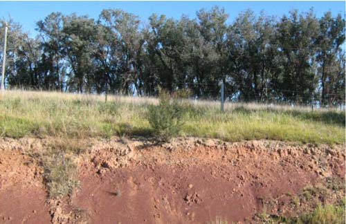 Purple and red siltstones and mudstones deposited during the Late Devonian Period. Roadside cutting near Glenaladale North |
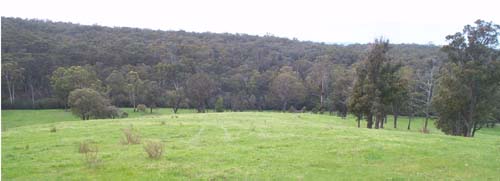
Original vegetation
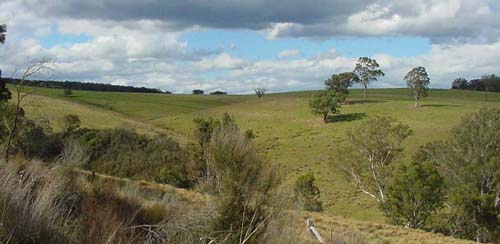
The original vegetation was a shrubby dry forest.
Previous maps and reports
This map unit is included within the Avon and Glenmaggie Land Systems as described by Aldrick et al. (1992).
Soils
Component 1: Moderate to gentle slopes
Surface soils are dark greyish brown to dark brown acidic fine sandy clay loams often with fragments of rock from the surface. The sub-surface is generally bleached. Yellowish brown to reddish brown medium clays, often with angular fragments of decomposing rock, occur from about 20 to 30 cm. The depth to rock is generally between 1.0 and 2.0 m and areas of rock outcrop without soil cover also occur. Occurrences of sheet and rill erosion are considered to be low to moderate on cleared slopes. Stones throughout the profile (up to 20 mm in diameter) are a common feature of many of the soils. The redder soils are considered as better than the yellower soils because they are better drained, less sodic and have less impedance to plant roots.
Component 2: Rounded crests
These soils are mostly similar to those described above but some areas of rock outcrops occur.
Component 3: Narrow open depressions
Gully erosion and stream-bank may be of local occurrence in drainage lines. Tunnel erosion is common in paddocks throughout this map unit in drainage lines and over whole paddocks. No pits were dug on this component.
| Location: Glenaladale North | Geo Ref: 529800E 5827000N |
| Australian Soil Classification: Bleached-Sodic, Magnesic, Brown CHROMOSOL | Brown texture contrast soil |
| General landscape description: Rolling to steep low hills | |
| Geology: Late Devonian freshwater sediments | |
| Site description: Upper slope, NNW aspect 5% slope | |
| Land use: Grazing | |
| Original Vegetation: Shrubby dry forest | |
| Map unit: Glenmaggie (Component 1) |
Soil profile morphology
Surface soil
| A1 | 0 – 10 cm | Very dark greyish brown (10YR3/2); fine sandy clay loam; moderate fine subangular blocky structure; few (2-10%) fine (<2 mm) round ferruginous concretions firm consistence dry; clear change to: | 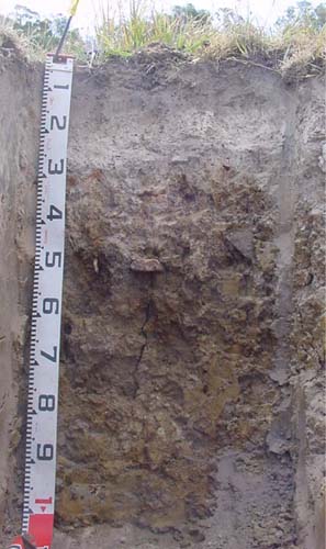 |
| A2 | 10– 25 cm | Dark greyish brown (10YR4/2), conspicuously bleached, light brownish grey dry (10YR6/2d); fine sandy clay loam; massive; few fine round ferruginous concretions; abrupt change to: | |
| Subsoil | |||
| B21 | 25 – 40 cm | Brown (7.5YR4/3) with common (10 -20%) fine yellowish brown (7.5YR5/6) mottles; medium clay; strong very coarse prismatic structure parting to fine angular blocky; very strong dry; few (2-10%) rounded tabular cobbles (<200 mm); gradual change to: | |
| B22 | 40 – 70 cm | Brown (10YR4/3); medium heavy clay; strong coarse prismatic structure; few fine round organic segregations; very strong dry; diffuse change to: | |
| B23 | 70 – 120 cm | Dark yellowish brown (10YR4/4); heavy clay; moderate coarse polyhedral structure; few fine round organic segregations; very strong dry; passing to: | |
| R | 120+ cm | Decomposing rock |
Key profile characteristics
- Strong texture contrast between the surface (A) and subsoil (B) horizons.
- Strongly bleached subsurface horizon.
Soil profile characteristics
pH | Sodicity | Slaking | Dispersion Dry | Dispersion Remoulded | |
| Surface soil (A horizon) | Strongly acid | Non-sodic | Minimal aggregation | Minimal aggregation | Minimal aggregation |
| Subsoil (B21 horizon) | Moderately acid | Non-sodic | Partial | Nil (2 hours), Nil (20 hours) | Nil (2 hours), Complete (20 hours) |
| Deep subsoil (B23 horizon) | Slightly alkaline | Sodic | Considerable | Moderate (2 hours), Moderate (20 hours) | Moderate (2 hours), Moderate (20 hours) |
| Horizon | Depth cm | Field texture | pH water | pH CaCl2 | EC dS/m | Coarse sand % | Fine sand % | Silt % | Clay % | Field cap. % w/w | Wilt. point % w/w | PAW* water % w/w |
| A1 | 0-10 | VFSCL | 5.2 | 4.4 | 0.07 | 5 | 61 | 17 | 8 | 24.9 | 6.4 | 18.5 |
| A2 | 10-25 | VFSCL | 5.4 | 4.4 | <0.05 | 6 | 60 | 17 | 12 | 21.1 | 4.8 | 16.3 |
| B21 | 25-40 | MC | 5.6 | 4.4 | 0.11 | 2 | 28 | 13 | 56 | 34.7 | 19.1 | 15.6 |
| B22 | 40-70 | MHC | 5.9 | 4.8 | 0.18 | 1 | 15 | 11 | 72 | 41.6 | 23.3 | 18.3 |
| B23 | 70-120 | MHC | 7.8 | 6.8 | 0.17 | 1 | 22 | 22 | 55 | 35.6 | 19.1 | 16.5 |
| Depth | OrgC# | Total N | Free Fe2O3 | Exch. Al | Exchangeable cations cmol(+)/kg | Ca:Mg | ESP | ||||||
cm | % | % | % w/w | ppm | Ca | Mg | K | Na | Total | H | CEC | ||
| 0-10 | 7.4 | 3.9 | 96 | 1.5 | 0.8 | 0.1 | <0.1 | 2.4 | 14 | 16.4 | 1.9 | ||
| 10-25 | 2.1 | 1.1 | 73 | 0.5 | 0.9 | <0.1 | 0.2 | 1.6 | 9.1 | 10.7 | 0.6 | 2 | |
| 25-40 | 200 | 0.5 | 6.5 | 0.1 | 1.2 | 8.3 | 16 | 24.3 | 0.08 | 5 | |||
| 40-70 | 82 | 0.2 | 11 | 0.1 | 2 | 13.3 | 14 | 27.2 | 0.02 | 7 | |||
| 70-120 | <5 | <0.1 | 10 | <0.1 | 1.8 | 11.8 | 4.4 | 16.2 | <0.01 | 11 | |||
Management considerations
Whole profile
- Plant available water capacity is considered to be quite low (estimated at 37 mm) for this soil profile. This is based on an estimated effective rooting depth of 32 cm (i.e. surface soil and the top of the clay horizon). The dense and coarsely structured upper subsoil is likely to restrict rooting depth.
Surface (A) horizons
- The surface soil is strongly acid. This indicates aluminium toxicity could occur in crops sensitive to aluminium toxicity, eg lucerne. Test strips may be used to determine if lime is economically justified.
- The surface (A1) horizon has a very low nutrient holding capacity (based on the sum of the exchangeable calcium, magnesium, potassium and sodium cations). Organic matter is important for maintaining soil fertility, water holding capacity and enhancing surface soil structure; especially in soils such as these with high fine sand contents.
- Potassium is very low and a response to potassium fertiliser would be expected.
- The low wilting point values (i.e. 6.4 and 4.8) of the surface horizons indicate plants will be able to utilise very light rains when the soil is dry. However, due to the low water storage capacity, plants will soon suffer moisture stress unless further rainfall occurs.
- The presence of a conspicuously bleached subsurface (A2) horizon indicates periodic waterlogging occurs above the more slowly permeable subsoil. This horizon also has a very low inherent fertility and will become ‘spewy’ when wet.
- The dense and coarsely structured subsoil is sodic. This will result in significantly restricted root and water movement into the subsoil. The use of gypsum in association with deep ripping has been advocated by some researchers as an effective way to ameliorate sodic subsoils, but this may not be an economic option. Deep ripping should not be carried out when the subsoil is in a moist to wet condition.
- The deep subsoil slakes considerably and shows moderate dispersion when wet. Such soils are prone to tunnel and gully erosion, particularly where subsoil water accumulates, for example in gullies.
- The low exchangeable calcium to magnesium ratio (<0.1) in the subsoil indicates some nutrient imbalances (eg calcium deficiency) could occur.
Site EG258
| Location: Glenaladale North | Geo Ref: 529600E 5826900N |
| Australian Soil Classification: Bleached-Sodic, Mesotrophic, Brown CHROMOSOL | Sodic brown texture contrast soil |
| General landscape description: Rolling to steep low hills | |
| Geology: Late Devonian freshwater sediments | |
| Site description: Mid-slope, WSW aspect 8% slope | |
| Land use: Grazing | |
| Original Vegetation: Shrubby dry forest | |
| Map unit: Glenmaggie (Component 1) |
Landscape similar to Pit 1
Soil profile morphology
Surface soil
| A1 | 0 – 5 cm | Very dark greyish brown (10YR3/2); clay loam; weak fine subangular block structure; weak consistence dry; clear change to: | 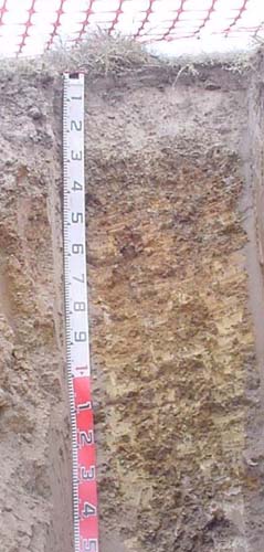 |
| A21 | 5 – 15 cm | Dark greyish brown (10YR4/2), conspicuously bleached, light brownish grey dry (10YR6/2d); very fine sandy clay loam; massive; few (<2%) angular charcoal fragments (<20 mm); abrupt change to: | |
| A22 | 15 – 23 cm | Brown (10YR5/3) conspicuously bleached light grey dry (10YR7/2); very fine sandy clay loam; massive; few (<2%) angular charcoal fragments (<20 mm abrupt change to: | |
| Subsoil | |||
| B21 | 23 – 40 cm | Brown (10YR4/3; medium clay; strong fine angular blocky structure; strong consistence dry; very few (<2%) ferruginous medium nodules (<6 mm); clear change to: | |
| B22 | 40 – 60 cm | Dark yellowish brown (10YR4/6); medium clay; moderate very coarse angular blocky structure; very strong dry; very few (<2%) ferruginous medium nodules (<6 mm); clear change to: | |
| C1 | 60 – 90 cm | Yellowish brown (10YR5/4); medium clay; massive; few fine round organic segregations; very strong dry; few (2-10%) ferruginous, organic and earthy nodules and veins; gradual change to: | |
| C2 | 90 – 120+ cm | Brownish yellow (10YR6/6); medium clay; massive; few fine round organic segregations; very strong dry; few (2-10%) ferruginous, organic and earthy nodules and veins; | |
| R | 120+ cm | Decomposing shale |
Key profile features
- Strong texture contrast between the surface (A) and subsoil (B) horizons.
- Strongly bleached subsurface horizon.
| pH | Sodicity | Slaking | Dispersion Dry | Dispersion Remoulded | |
| Surface soil (A horizon) | Strongly acid | Non-sodic | Water stable | Nil (2 hours), Nil (20 hours) | Nil (2 hours), Slight (20 hours) |
| Subsoil (B21 horizon) | Moderately acid | Non-sodic | Partial | Nil (2 hours), Nil (20 hours) | Strong (2 hours), Complete (20 hours) |
| Deep subsoil (90-120cm) | Slightly acid | Sodic | Partial | Strong (2 hours), Complete (20 hours) | Strong (2 hours), Complete (20 hours) |
| Horizon | Depth cm | Field texture | pH water | pH CaCl2 | EC dS/m | Coarse sand % | Fine sand % | Silt % | Clay % | Field cap. % w/w | Wilt. point % w/w | PAW* water % w/w |
| A1 | 0-5 | CL | 5.2 | 4.4 | 0.09 | 8 | 46 | 27 | 10 | 36.3 | 10.3 | 26.0 |
| A21 | 5-15 | FSCL | 5.5 | 4.6 | <0.05 | 9 | 51 | 28 | 12 | 24.4 | 4.8 | 19.6 |
| A22 | 15-23 | FSCL | 5.7 | 4.8 | <0.05 | 4 | 50 | 28 | 15 | 24.7 | 4.9 | 19.8 |
| B21 | 23-40 | MC | 5.7 | 4.4 | 0.06 | 4 | 24 | 18 | 53 | 34.1 | 19.6 | 14.5 |
| B22 | 40-60 | MC | 5.7 | 4.4 | 0.07 | 1 | 27 | 17 | 53 | 38.4 | 19.8 | 18.6 |
| C1 | 60-90 | MC | 6.2 | 4.8 | 0.09 | 1 | 31 | 18 | 46 | 29.6 | 16 | 13.6 |
| C2 | 90-120 | MC | 7.9 | 6.5 | 0.13 | 1 | 32 | 24 | 44 | 28.2 | 15.9 | 12.3 |
| Depth | OrgC# | Total N | Free Fe2O3 | Exch. Al | Exchangeable cations cmol(+)/kg | Ca:Mg | ESP | ||||||
| cm | % | % | % w/w | ppm | Ca | Mg | K | Na | Total | H | CEC | ||
| 0-5 | 5.3 | 0.34 | 110 | 2.4 | 1.1 | 0.5 | <0.1 | 4.1 | 16 | 20.1 | 2.2 | ||
| 5-15 | 0.38 | <0.05 | 53 | 1.4 | 0.9 | 0.2 | <0.1 | 2.6 | 11 | 13.6 | 1.6 | ||
| 15-23 | 1.9 | 0.08 | 27 | 1 | 1.1 | 0.2 | <0.1 | 2.4 | 8.5 | 10.9 | 0.9 | ||
| 23-40 | 150 | 1 | 4.6 | 0.3 | 0.5 | 6.4 | 14 | 20.4 | 0.3 | 3 | |||
| 40-60 | 250 | 0.5 | 5.6 | 0.3 | 0.7 | 7.1 | 14 | 21.1 | 0.1 | 3 | |||
| 60-90 | 51 | 0.2 | 7.8 | 0.1 | 1.3 | 9.4 | 7.6 | 17 | 0.1 | 8 | |||
| 90-120 | <5 | 0.3 | 9.8 | <0.1 | 1.9 | 12 | 3.4 | 15.4 | 0.1 | 12 | |||
Management considerations
Whole profile
- Plant available water capacity is considered to be low (estimated at 55 mm) for this soil profile. This is based on an estimated effective rooting depth of 35 cm (i.e. surface soil and the top of the clay horizon). The dense and coarsely structured upper subsoil is likely to restrict rooting depth.
Surface (A) horizons
- The surface soil is strongly acid. This indicates aluminium toxicity could occur in crops sensitive to aluminium toxicity, eg lucerne. Test strips may be used to determine if lime is economically justified.
- The surface (A1) horizon has a very low nutrient holding capacity (based on the sum of the exchangeable calcium, magnesium, potassium and sodium cations). Organic matter is important for maintaining soil fertility, water holding capacity and enhancing surface soil structure; especially in soils such as these with high fine sand contents.
- Potassium levels are moderate and no response to potassium would be expected.
- The low wilting point values (i.e. 10.3 and 4.8) of the surface horizons indicates plants will be able to utilise very light rains when the soil is dry. However, due to the low water storage capacity, plants will soon suffer moisture stress unless further rainfall occurs.
- The presence of a conspicuously bleached subsurface (A2) horizon indicates periodic waterlogging occurs above the more slowly permeable subsoil. This horizon also has a very low inherent fertility (based on the level of exchangeable cations) and will become ‘spewy’ when wet.
Subsoil (B) horizons
- The dense and coarsely structured subsoil is sodic. This will result in significantly restricted root and water movement into the subsoil. The use of gypsum in association with deep ripping has been advocated by some researchers as an effective way to ameliorate sodic subsoils, but this may not be an economic option. Deep ripping should not be carried out when the subsoil is in a moist to wet condition.
- The deep subsoil slakes considerably and shows moderate dispersion when wet. Such soils are prone to tunnel and gully erosion, particularly where subsoil water accumulates, for example in gullies.
Site EG259
| Location: Glenaladale | Geo Ref: 521860E 5821870N |
| Australian Soil Classification: Bleached, Mesotrophic, Red KUROSOL | Acidic red texture contrast soil |
| General landscape description: Rolling to steep low hills | |
| Geology: Late Devonian freshwater sediments | |
| Site description: Mid-slope, N aspect, 20% slope | |
| Land use: Grazing | |
| Original Vegetation: Shrubby dry forest | |
| Map unit: Glenaladale (Component 1) |
Soil profile morphology
Surface soil
| A1 | 0 – 10 cm | Dark brown (7.5YR3/2); very fine sandy clay loam; moderate fine (<20 mm) subangular blocky structure; very few (<2%) angular pebbles (6-20 mm); clear change to: | 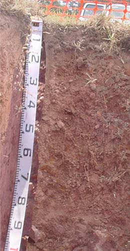 |
| A2 | 10 - 30 cm | Reddish brown (5YR4/3); conspicuously bleached pinkish grey (5YR6/2d); fine sandy clay loam; moderate very coarse structure; strong consistence dry; clear change to: | |
| Subsoil | |||
| B2 | 30 - 50 cm | Reddish brown (5YR4/4); light medium clay; weak coarse (50-100 mm) prismatic structure; parting to strong medium to fine angular blocky; strong consistence dry; gradual change to: | |
| C | 50 -100 cm | Reddish brown (5YR4/4); light medium clay; strong medium subangular blocky structure; few (2-10%) angular shale cobbles increasing with depth passing to: | |
| R | 100+ cm | Decomposing red shale |
- Weak colour contrast between the surface (A) horizons and the subsoil (B) horizons.
- Red colours throughout the soil profile.
- Strong medium to fine structure in the B horizon which facilitates root development.
| pH | Sodicity | Slaking | Dispersion Dry | Dispersion Remoulded | |
| Surface soil (A horizon) | 5.0 | Non-sodic | Partial | Nil (2 hours), Nil (20 hours) | Nil (2 hours), Nil (20 hours) |
| Subsoil (B2 horizon) | 5.3 | Non-sodic | Partial | Slight (2 hours), Slight (20 hours) | Strong (2 hours), Complete (20 hours) |
| Deep subsoil (C horizon) | 5.6 | Non-sodic | Partial | Strong (2 hours), Complete (20 hours) | Strong (2 hours), Complete (20 hours) |
| Horizon | Depth cm | Field texture | pH water | pH CaCl2 | EC dS/m | Coarse sand % | Fine sand % | Silt % | Clay % | Field cap. % w/w | Wilt. point % w/w | PAW* water w/w |
| A1 | 0-10 | FSL | 5.0 | 4.4 | 0.08 | 22 | 29 | 25 | 13 | 28.7 | 11.5 | 17.2 |
| A2 | 10-30 | FSCL | 5.2 | 4.3 | <0.05 | 15 | 31 | 31 | 19 | 22.5 | 8.8 | 13.7 |
| B2 | 30-50 | MC | 5.3 | 4.2 | <0.05 | 4 | 14 | 32 | 48 | 30.8 | 17.9 | 12.9 |
| C | 50-100 | MC | 5.6 | 4.4 | 0.08 | 2 | 12 | 32 | 55 | 33.8 | 19.9 | 13.9 |
| Depth | OrgC# | Total N | Free Fe2O3 | Exch. Al | Exchangeable cations cmol(+)/kg | Ca:Mg | ESP | ||||||
cm | % | % | % w/w | ppm | Ca | Mg | K | Na | Total | H | CEC | ||
| 0-10 | 5.5 | 0.33 | 130 | 2.9 | 1.2 | 0.2 | 0.2 | 4.4 | 16 | 20.4 | 2.4 | ||
| 10-30 | 1.1 | 0.06 | 120 | 1.0 | 0.9 | <0.1 | <0.1 | 2.1 | 9.1 | 11.2 | 1.1 | ||
| 30-50 | 270 | 0.5 | 2.5 | 0.1 | 0.1 | 3.2 | 11 | 14.2 | 0.2 | 1 | |||
| 50-100 | 140 | <0.1 | 4.4 | 0.1 | 0.6 | 5.2 | 8.4 | 13.6 | <0.1 | 4 | |||
Management considerations
Whole profile
- There is amarked increase in soil texture down the soil profile.
- Bleached A2 horizon when dry (does not show on a moist pit face shown here).
- The plant available water capacity is considered to be moderate (estimated at 75 mm) based on an effective rooting depth of 80 cm, which is slightly limited by the presence of stone in the profile.
- Exchangeable aluminium levels are high and likely to affect aluminium sensitive species.
- The surface soil is strongly acid. This indicates aluminium toxicity could occur in crops sensitive to aluminium toxicity, eg lucerne. Test strips may be used to determine if lime is economically justified.
- The surface (A1) horizon has a low nutrient holding capacity (based on the sum of the exchangeable calcium, magnesium, potassium and sodium cations). Organic matter is important for maintaining soil fertility, water holding capacity.
- Potassium is deficient and a response to potassium fertiliser would be expected.
- Even though the soil has a marked increase in clay content between the A2 and B21 horizons, it does not appear to have affected root penetration. This has resulted in the soil’s moderate ability to retain water.
- The subsoil is non-sodic and has a strong medium to fine angular blocky structure which allows good root penetration.
- Although the deeper subsoil is non-sodic, slakes partially and completely disperses when wet for 20 hours. Such soils may be prone to tunnel and gully erosion, particularly where subsoil water accumulates, for example in gullies.
© State of Victoria (Agriculture Victoria) 1996 - .

This work, Victorian Resources Online, is licensed under a Creative Commons Attribution 4.0 licence. You are free to re-use the work under that licence, on the condition that you credit the State of Victoria (Agriculture Victoria) as author, indicate if changes were made and comply with the other licence terms.
The licence does not apply to ‘branding’ or some ‘images or photographs’ that may be owned by third parties. We ask you to seek prior approval to use images using the VRO feedback form. Access to higher quality images can also be provided on request.
This page was last updated on .