
Nindoo (Symbol: Nn)
Sample No. GR15
Geology
Pleistocene alluvial sediments. These areas, referred to on the geological maps as Qp1, are regarded as being the oldest of six alluvial terraces deposited during the Pleistocene Period and occur well above the level of the Red Gum Plains. Only remnants of this terrace survive, as they have been eroded away over the past million years or so. These remnants may be found in the higher plateaus in the northern part of the area.
Landform
This is a minor soil/landform Map unit and occurs in minor areas north of the Mitchell River and around Glenaladale. A considerable period of time has elapsed since these terraces were deposited and they have been mostly eroded away. Whilst these remnants are relatively flat, they fall sharply away where they adjoin drainage lines.
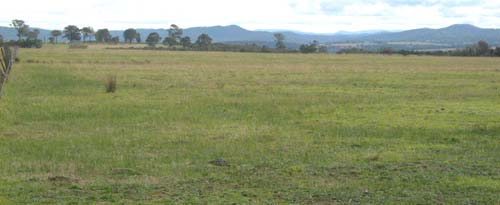
Old alluvial terrace (Nindoo Map unit), photo taken from Weir Lane north of Wuk Wuk.
| Native vegetation The original vegetation was plains grassy woodland. Soils All the soils show marked texture contrast with strongly to moderately acidic sands to loamy sands surface soils overlying, at about 30 to 50 cm, clay subsoils. These subsoils may be non-sodic and non-magnesic or sodic and magnesic. Rounded stones up to about 100 mm occur throughout the profile. No pits were dug during this study. The data given below from Little and Ward (unpublished). Previous maps and reports This map unit is included within the Red Gum 1 Land System as described by Aldrick et al (1992). Land use All the land has been cleared and used for grazing. The soils are too stony for deep cultivation. | 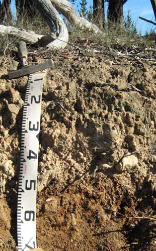 |
| Location: Glenaladale | |
| Australian Soil Classification: Mottled-Sodic, Eutrophic, Brown CHROMOSOL | |
| Map unit: Nindoo |
| Depth cm | Colour | Texture | pH | TSS % | Grv % | CS % | FS % | Silt % | Clay % | Org C % | Tot N % | Exchangeable cations cmol(+)/kg | Ca:Mg | ESP | ||||
| Ca | Mg | K | Na | CEC | ||||||||||||||
| 0-10 | Dark grey | S | 6.0 | 0.03 | 19 | 48 | 10 | 7 | 3.8 | 0.15 | 5.8 | 2.7 | 0.61 | 0.10 | 19.9 | 2.1 | 1 | |
| 30-45 | Yellowish brown with red mottles | HC | 5.7 | 0.02 | 9 | 12 | 1 | 78 | 1.5 | 6.0 | 0.24 | 1.3 | 31.0 | 0.3 | 4 | |||
| 120-135 | Greyish brown mottled with yellowish brown | HC | 5.0 | 0.08 | 23 | 12 | 6 | 59 | 0.62 | 6.2 | 0.17 | 2.0 | 22.0 | 0.1 | 9 | |||
© State of Victoria (Agriculture Victoria) 1996 - .

This work, Victorian Resources Online, is licensed under a Creative Commons Attribution 4.0 licence. You are free to re-use the work under that licence, on the condition that you credit the State of Victoria (Agriculture Victoria) as author, indicate if changes were made and comply with the other licence terms.
The licence does not apply to ‘branding’ or some ‘images or photographs’ that may be owned by third parties. We ask you to seek prior approval to use images using the VRO feedback form. Access to higher quality images can also be provided on request.
This page was last updated on .