
Tea Tree (Symbol: Tt)
Geology
Holocene and Pleistocene alluvium.
Landform
Alluvial plain, comprising flood plains, minor alluvial fans and stream channels.
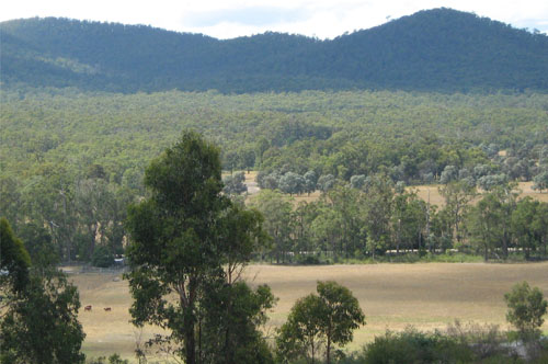
Creek flats south of Buchan. This photo was taken about 8.5 Km south of Buchan looking east towards the
Buchan-Bruthen Road
Soils
Component 1 (Soils on the flood plains)
The Holocene and Pleistocene alluvium occur in the river and creek flood plains and are subject to periodic waterlogging. The soils of the Buchan river flats appear to be gradational soils with slightly acidic very dark greyish brown clay loam surface soils passing to brown medium clays in the subsoil.
South of Buchan, the soils appear to be texture contrast soils with very dark grey acidic fine sandy loams to clay loams overlying a bleached similarly textured subsurface horizon. Mottled yellowish brown clays occur in the subsoil. Because of their limited extent, all of the soils are grouped under the Tea Tree map unit.
Components 2 and 3
No information is given for the alluvial fans and stream channels.
Native vegetation
The original vegetation of the Buchan Valley was riparian forest. The drainage lines and creek flats south of Buchan carried a range of ecological vegetation types, mostly riparian scrub and clay heathland.
Land use
The Buchan Valley is entirely cleared but there are remnants of the original vegetation around Kanni and Racecourse Roads.
© State of Victoria (Agriculture Victoria) 1996 - .

This work, Victorian Resources Online, is licensed under a Creative Commons Attribution 4.0 licence. You are free to re-use the work under that licence, on the condition that you credit the State of Victoria (Agriculture Victoria) as author, indicate if changes were made and comply with the other licence terms.
The licence does not apply to ‘branding’ or some ‘images or photographs’ that may be owned by third parties. We ask you to seek prior approval to use images using the VRO feedback form. Access to higher quality images can also be provided on request.
This page was last updated on .