
Tambo (Symbol: Tb)
Geology
Palaeozoic sediments, deeply weathered.
Landform
Rolling low hills.
Enclosed rolling low hills, with steep hills often adjoining stream lines. Elevation range in this area 200 - 300 m with local relief 30 – 90 m, and slope gradients <32 %. Broad concave drainage lines with slope gradients generally less than 5 %.
The Tambo map unit may be subdivided into four components: moderate to gentle slopes are the most extensive component, generally without rock outcrops. Areas comprising open depressions and steep slopes generally with rock outcrop are less extensive.
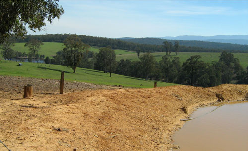
Farm dam on the Tambo map unit. The suspended sediment in the dam is an indication that the subsoil is probably sodic.
| Soils Because of their limited extent, the soils on the various components are not described in detail here. They do occur extensively around Clifton Creek and Bruthen and will be described in detail in a publication covering the soils around Bairnsdale and Dargo. Where there is sufficient depth to decomposing sedimentary rock, texture contrast soils (displaying a clear differentiation between clay subsoil and lighter textured topsoil) are formed. The surface soil is usually a strongly acidic brown to dark brown fine sandy loam surface soil overlying yellowish brown light to medium clay. The subsurface soil above the clay is generally bleached. Otherwise the soils are brown fine sandy clay loams to clay loams, overlying light clay with decomposing sedimentary rock at a shallower depth. The two soils examined generally become less acidic with depth; the surface soil pH in water were 4.5 and 5.1 and for the subsoils, 5.3 and 6.7. Subsoil sodicity is common in these soils, resulting in them being dispersive. Drainage lines are particularly prone to gully and tunnel erosion. Native vegetation In general, shrubby dry forest on higher elevations, lowland forest at lower elevations. Land use Mostly uncleared. Where the soils are grazed, the soils are likely to have reasonable water retention. | 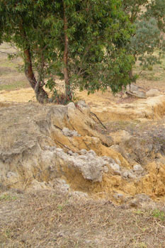 Gully erosion in a drainage line. |
© State of Victoria (Agriculture Victoria) 1996 - .

This work, Victorian Resources Online, is licensed under a Creative Commons Attribution 4.0 licence. You are free to re-use the work under that licence, on the condition that you credit the State of Victoria (Agriculture Victoria) as author, indicate if changes were made and comply with the other licence terms.
The licence does not apply to ‘branding’ or some ‘images or photographs’ that may be owned by third parties. We ask you to seek prior approval to use images using the VRO feedback form. Access to higher quality images can also be provided on request.
This page was last updated on .