
Gelantipy (Symbol: Gy)
EG83 | EG84 | EG216
Geology
Palaeogene (early to mid Tertiary) basaltic volcanic rocks. The basalts occupy an old abandoned valley that lies about 200 m above the valley of the present drainage system (Webb et al., 1991).
Landform
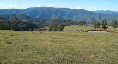
The undulating to rolling low hills of the Gelantipy map unit have an elevation range of about 600 to 950 m and, apart from the escarpment, a relief range of about 30 to 90 m. The landform may also be described as a dissected plateau, mostly comprised of basalt, with the rocks below the escarpment and above the dissected plateau being the Snowy River Volcanics. In parts, basalt may extend some distance down the escarpment. Slopes are generally less than 32% but on the escarpment are much steeper, with slopes up to about 60%.
It is arbitrarily separated from the W Tree map unit on the basis of its vegetation class, elevation and generally more gentle topography.
This map unit may be subdivided into at least three components: undulating rises, gently undulating plains, and open drainage lines.
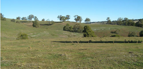
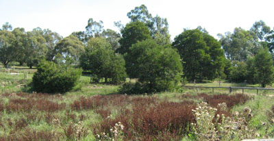
Rolling low hills of the Gelantipy map unit. Photo taken south of Gelantipy. Basalt rocks are exposed on the
slopes adjoining the drainage line.
Native vegetation
Montane grassy woodland.
Soils
The soils are quite variable, and seem to depend on their external drainage and slope.
Component 1: Soils on the gently undulating rises.
On the well drained slopes of the undulating rises the surface soils are mostly dark reddish brown clay loams, with minor occurrences of dark greyish brown clay loams. There is little colour change down the profile but there is usually an increase in clay content to medium clay. The reddish colours indicate the soils are high in iron oxide and of the two analysed, one had iron oxides exceeding 5%. These soils have a favourable soil structure and, depending on the depth to rock, a moderate to high nutrient and water holding capacity.
Component 2: Gently undulating plains
Soils similar to those described for component 1 do occur but in areas where the soil is less well drained there is an abrupt change from the clay loam to silty loam surface and subsurface soils and the clay subsoil. Concretions high in iron oxide, or ferruginous segregations, commonly termed ‘buckshot’ are usually found above the clay. These soils have a weakly developed soil structure and tend to set hard when dry.
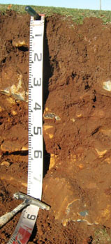 Reddish brown well structured gradational soil on basalt. | 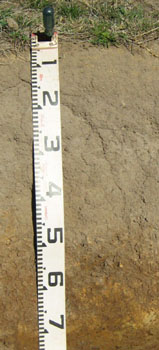 Grey brown poorly structured texture contract soil on basalt. ‘Buckshot’ (ferruginous segregations) occurs above the clay horizon. These soils occur in areas of impeded drainage. |
Other than various types of soil, rock is often exposed on the slopes adjoining the drainage lines.
Land use
Apart from remnants of original vegetation, the land has been cleared and used for grazing or occasionally, horticulture.
Site EG83
| Location: Wulgulmerang | Geo. Ref. 608700E 5864800N |
| Australian soil classification: Haplic, Eutrophic, Brown CHROMOSOL (Stony) | Stony brown texture contrast soil |
| General landscape description: Plateau | |
| Geology: Tertiary basalt | |
| Site description: Lower slope, <2% slope (Roadside exposure) | |
| Land use: Grazing | |
| Native vegetation: Montane grassy woodland | |
| Map unit: Gelantipy (Component 1) |
Soil profile morphology
| Surface soil |  | ||
| A1 | 0 – 30 cm | Brown (7.5YR3/2); silty clay loam; strong coarse polyhedral structure; firm consistence moderately moist; many (20 - 50%) subrounded basalt stones (200 – 600 mm); clear change to: | |
| Subsoil | |||
| B2 | 30 - 55+cm | Brown (7.5YR4/2); medium clay; moderate to strong medium prismatic structure; very firm consistence moderately moist; abundant (50 – 90%) subrounded basalt stones (200 – 600 mm) | |
Key profile features
| |||
Soil profile characteristics
| pH | Salinity rating | Sodicity | Dispersion | Slaking | |
| Surface soil (A1 horizon) | Slightly acid | Very low | Non sodic | None | Slakes partially |
| Subsoil (B2 horizon) | Slightly acid | Very low | Non sodic | None | Slakes partially |
| Horizon | Depth cm | Field texture | pH water | pH CaCl2 | EC dS/m | Coarse sand % | Fine sand % | Silt % | Clay % | Field cap. % w/w | Wilt. point % w/w | PAW* water % w/w |
| A1 | 0-30 | CL | 6.3 | 5.7 | 0.06 | 11 | 34 | 26 | 25 | 41 | 17.9 | 23.1 |
| B2 | 30-55 | MC | 6.7 | 5.9 | 0.11 | 5 | 26 | 21 | 42 | 47.9 | 29.3 | 18.6 |
| Depth | OrgC# | Total N | Free Fe2O3 | Exch. Al | Exchangeable cations cmol(+)/kg | Ca:Mg | ESP | ||||||
| cm | % | % | % w/w | ppm | Ca | Mg | K | Na | Total | H | CEC | ||
| 0-15 | 2.3 | 0.2 | 2.1 | <1 | 11 | 6.4 | 0.34 | 0.29 | 18 | 9.2 | 27.2 | 1.8 | 1 |
| 20-30 | 2.4 | 17 | 13 | 0.35 | 0.29 | 31 | 10.0 | 41.0 | 1.3 | 1 | |||
Management considerations
Whole profile
- The profile is slightly acid throughout.
- These soils are well drained due their strongly developed structure.
- Plant available water capacity is considered to be low, estimated at 45 mm based on the laboratory data, and taking into consideration the presence of basalt stones.
- The soil has low organic matter content. Organic matter will be better maintained under rotational grazing, which enables stronger pasture recovery, rather than set stocking.
- The nutrient holding capacity of the soil is high (based on the sum of the exchangeable basic cations).
- Potassium levels are low to moderate.
- The friable nature of the subsoil allows deep penetration of plant roots until the basalt rock is encountered.
- The friable nature of the subsoil and the presence of rock will lead to problems with sealing of earth dams.
| Location: Gelantipy | Geo. Ref. 611800E 5879600N |
| Australian soil classification: Ferric, Eutrophic, Grey CHROMOSOL (thick surface) | Grey texture contrast soil |
| General landscape description: Plateau | |
| Geology: Tertiary basalt | |
| Site description: Upper slope, ENE aspect, 11 % slope | |
| Land use: Unused | |
| Native vegetation: Montane grassy woodland | |
| Map unit: Gelantipy (Component 2) |
Soil profile morphology
| Surface soil | 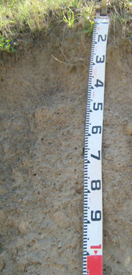 | ||
| A1 | 0 – 5 cm | Dark greyish brown (10YR4/2); silty loam; weak crumb structure; firm consistence dry; few (2 – 10%) medium (2 – 6 mm) ferruginous concretions; gradual change to: | |
| A21 | 5 – 50 cm | Greyish brown (10YR5/2); silty loam; massive; very firm consistence dry; few (2 – 10%) medium (2 – 6 mm) ferruginous concretions; clear wavy change to: | |
| A22 | 50 – 60 cm | Greyish brown (10YR5/2); silty loam; massive; strong consistence dry; many (20 – 50%) medium (2 – 6 mm) ferruginous concretions; clear wavy change to: | |
| Subsoil | |||
| B2 | 60 – 100+ cm | Grey (10YR5/1) finely mottled with brownish yellow (10YR6/6); heavy clay; strong coarse prismatic structure, very strong consistence dry; very many (>50%) medium to coarse (2 – 20 mm) ferruginous concretions and many (20 – 50%) rounded basalt stones (60 – 200 mm) |
Key profile features
- Strong texture contrast between surface (A) horizon and subsurface (B2) horizon.
| pH | Salinity rating | Sodicity | Dispersion | Slaking | |
| Surface soil (A1 horizon) | Slightly acidic | Very low | Non sodic | None1 | Slakes partially |
| Subsoil (B2 horizon) | Slightly acidic | Very low | Non sodic | None2 | Slakes partially |
| Horizon | Depth cm | Field texture | pH water | pH CaCl2 | EC dS/m | Coarse sand % | Fine sand % | Silt % | Clay % | Field cap. % w/w | Wilt. point % w/w | PAW* water % w/w |
| A2 | 5-50 | ZL | 6.1 | 5.3 | <0.05 | 9 | 41 | 30 | 16 | 27.9 | 6.4 | 21.5 |
| B2 | 60-100 | HC | 6.7 | 6.2 | <0.05 | 8 | 24 | 22 | 46 | 42.4 | 22.4 | 20.0 |
| Depth | OrgC# | Total N | Free Fe2O3 | Exch. Al | Exchangeable cations cmol(+)/kg | Ca:Mg | ESP | ||||||
| cm | % | % | % w/w | ppm | Ca | Mg | K | Na | Total | H | CEC | ||
| 5-50 | 0.76 | <0.05 | 2.2 | <1 | 2.8 | 1.3 | 0.07 | 0.11 | 4.3 | 6.4 | 10.7 | 2.2 | 1 |
| 60-100 | 4.1 | 8.1 | 12 | 0.14 | 0.74 | 21 | 7.6 | 30.6 | 0.7 | 2 | |||
Management considerations
Whole profile
- The profile is slightly acid throughout
- Plant roots would find it difficult to penetrate the massive subsurface (A21 and A22) horizons which would be hard setting when dry
- Plant available water capacity is considered to be low; estimated at 57 mm.
- The nutrient holding capacity of the soil is low (based on the sum of the exchangeable basic cations and the depth of roots observed)
- Potassium levels are very low and a response to potassium would be expected.
| Location: Gelantipy | Geo. Ref. 0615000E 5877700N |
| Australian soil classification: Haplic, Eutrophic, Red FERROSOL (Stony) | Stony red gradational soil |
| General landscape description: Plateau | |
| Geology: Tertiary basalt | |
| Site description: Gently undulating plain, <2% slope, few (2 – 10%) scattered rounded basalt stones (200 – 600 mm) | |
| Land use: Grazing | |
| Native vegetation: Montane grassy woodland | |
| Map unit: Gelantipy (Component 1) |
Soil profile morphology
| A11 | 0 – 20 cm | Dark reddish brown (5YR3/4); heavy clay loam; strong fine (2 – 5 mm) granular structure; common (10 – 20%) subrounded cobbles (60 – 200 mm) weak consistence moist; gradual change to: | 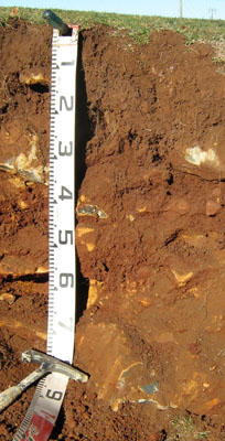 |
| A12 | 20 – 40 cm | Dark red (2.5YR3/6); light clay; strong fine (5 – 10 mm) polyhedral structure; many (20 – 50%) subrounded cobbles (60 – 200 mm); firm consistence dry; gradual change to: | |
| B2 | 40 -70 mm | Red (2.5YR4/6); medium clay; strong medium (10 – 20 mm) polyhedral structure; abundant (50 – 90%) subrounded stones (200 – 600 mm); firm consistence dry; becoming too rocky to excavate. | |
Key profile features
| |||
Soil profile characteristics
| pH | Salinity rating | Sodicity | Dispersion | Slaking | |
| Surface soil (A11 horizon) | Moderately acid | Very low | Non sodic | None | Slakes partially |
| Subsoil (A12 horizon) | Moderately acid | Very low | Non sodic | None | Slakes considerably |
| Deeper subsoil (40-70 cm) | Moderately acid | Very low | Non sodic | None | Slakes considerably |
| Horizon | Depth cm | Field texture | pH water | pH CaCl2 | EC dS/m | Coarse sand % | Fine sand % | Silt % | Clay % | Field cap. % w/w | Wilt. point % w/w | PAW* water % w/w |
| A11 | 0-20 | CL | 5.8 | 4.9 | 0.05 | 9 | 27 | 20 | 33 | 41.6 | 17.9 | 23.7 |
| A12 | 20-40 | LC | 6 | 4.9 | <0.05 | 7 | 22 | 24 | 40 | 46.8 | 21.4 | 25.4 |
| B2 | 40-70 | MC | 5.7 | 4.5 | <0.05 | 9 | 20 | 22 | 45 | 55.3 | 28.3 | 27.0 |
| Depth | OrgC# | Total N | Free Fe2O3 | Exch. Al | Exchangeable cations cmol(+)/kg | Ca:Mg | ESP | ||||||
| cm | % | % | % w/w | ppm | Ca | Mg | K | Na | Total | H | CEC | ||
| 0-20 | 4.3 | 0.28 | <10 | 8.1 | 4.6 | 0.18 | 0.27 | 13.2 | 13 | 26.2 | 1.8 | 1 | |
| 20-40 | 1.1 | 0.5 | 27 | 5.3 | 7.0 | <0.05 | 0.3 | 12.6 | 12 | 24.6 | 0.8 | 1 | |
| 40-70 | 0.53 | <0.5 | 130 | 4.6 | 11.0 | <0.05 | 0.68 | 16.3 | 14 | 30.3 | 0.4 | 2 | |
Management considerations
Whole profile
- The profile is moderately acid throughout.
- These soils are very well drained due to their strongly developed subsoil structure. This is due to the high iron oxide content which, although not measured in the laboratory, is likely to exceed 5% in the subsoil.
- Plant available water capacity is considered to be low, estimated at 61 mm based on the laboratory data, the presence of cobbles and stones in the subsoil and the shallow nature of the soil.
- The soil has moderate to high organic matter content, estimated at 7.3% which gives the soil its strongly developed structure.
- The nutrient holding capacity of the soil is high (based on the sum of the exchangeable basic cations).
- Potassium levels are very low and a strong response to potassium fertilisers would be expected.
- Due to their anticipated high iron oxide contents based on their strong ‘red’ colour and basaltic origin, these soils tend to ‘fix’ phosphorus which makes it unavailable to plants. Regular phosphorus application will assist in overcoming such a deficiency. Addition of molybdenum may also be required and this can be assessed by plant tissue analysis of clover. Zinc and copper can also be 'fixed' by high iron oxide contents.
- The friable nature of the subsoil allows good penetration of plant roots until rock is encountered.
- The friable nature of the subsoil together with the shallow depth to rock would lead to problems with sealing of earth dams.
- The subsurface soil has high levels of exchangeable aluminium (130 ppm) and is moderately acidic. This could restrict the growth of deep-rooted aluminium sensitive species, such as lucerne, as aluminium and manganese toxicity may occur. There should be likely long term benefits of applying lime, preferably incorporated, on this site if the test results are representative of the paddock. A pH/aluminium test is, however, best performed from samples taken across the paddock and bulked together. Other factors need to be considered, however, before lime is recommended (eg. pasture species grown, method of application, local trial responses, soil surface structure and likely cost/benefit).
© State of Victoria (Agriculture Victoria) 1996 - 2025.

This work, Victorian Resources Online, is licensed under a Creative Commons Attribution 4.0 licence. You are free to re-use the work under that licence, on the condition that you credit the State of Victoria (Agriculture Victoria) as author, indicate if changes were made and comply with the other licence terms.
The licence does not apply to ‘branding’ or some ‘images or photographs’ that may be owned by third parties. We ask you to seek prior approval to use images using the VRO feedback form. Access to higher quality images can also be provided on request.
This page was last updated on 23/03/2020.