
Buchan (Symbol: Bc)
EG24
Geology
Devonian marine sediments, predominantly limestone. Two limestone formations occur in the area: called the Buchan and Murrindal Formations. The Buchan Formation is recrystallised massive limestone and the Murrindal Formation is a softer material called marlstone. This unit encompasses the soils on the Buchan Formation.
Landform
Rolling low hills to steep hills with an elevation range of about 80 to 350 m. The relief is less than 300 m with much of the land having lower relief of less than 90 m. Most of the area comprises long moderately inclined slopes with smaller areas of rock outcrop, lower slopes and alluvial fans and drainage lines.
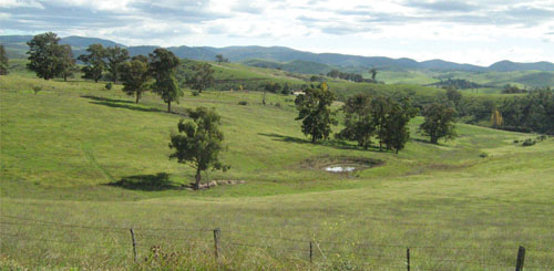
Rolling hills on limestone south-east of Buchan, looking towards Buchan from the Orbost - Buchan Road
Native vegetation
Grassy woodland.
Soils
Component 1. Soils on long moderately inclined slopes
The soils of this map unit are quite variable in terms of colour, depth, and presence of stone above the limestone rock. There may be some relationship between depth of soil and slope and aspect, but this could not be determined during this study. In some instances, areas of limestone rock were exposed at the surface. Most soils are dark brown, alkaline and since lime occurs within the root zone, are unlikely to show any response to additional lime. The soils have a high nutrient holding capacity (based on the exchangeable cations), but the water holding capacity may be limited due to the shallow depth to rock.
Components 2 and 3.Soils on lower slopes and alluvial fans and drainage lines
No soils were examined, but it is likely the soils are darker in colour and the depth of soil above the rock is deeper.
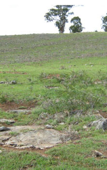 Limestone rock exposed at the surface near Murrindal | 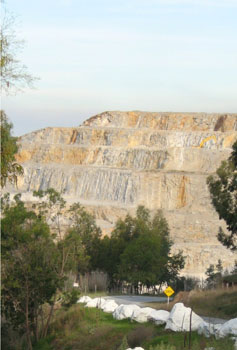 Limestone quarry north of Buchan |
Site EG24
| Location: Buchan-Orbost Road | Geo. Ref. 607200E 5849100N |
| Australian soil classification: Haplic, Petrocalcic, Red DERMOSOL (Shallow) | Red uniform textured soil over limestone |
| General landscape description: Rolling hills | |
| Geology: Devonian limestone | |
| Site description: Mid slope of a low hill, Southern aspect 7% slope | |
| Land use: Grazing | |
| Native vegetation: Grassy woodland | |
| Map unit: Buchan (Component 1) |
[
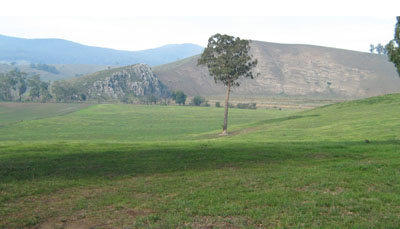
Photo taken from the site looking south over the Buchan River Valley. This photo shows the harder steeply bedded limestone,
called the Buchan Formation on the left on the far side of the valley and the softer marlstone, called the Murrindal Formation on the right
Soil profile morphology
| Surface condition: | 20% cover of angular limestone boulders (up to 2 m), 20% rock outcrop | 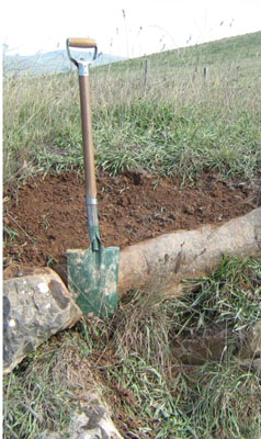 | |
| Surface soil: Underlying rock: R | 0 – 0/55 cm 0/55+ cm | Dark reddish brown (5YR3/3) medium clay; strong medium blocky structure; firm consistence, moist; abundant (50-90%) angular limestone pebbles (up to 60 mm); abrupt broken change to: Limestone | |
Key profile features
| |||
| pH | Salinity rating | Sodicity | Dispersion | Slaking | |
| Surface soil (A1 horizon) | Slightly alkaline | Very low | Non sodic | None | Water stable |
| Horizon | Depth cm | Field texture | pH water | pH CaCl2 | EC dS/m | Coarse sand % | Fine sand % | Silt % | Clay % | Field cap. % w/w | Wilt. point % w/w | PAW* water % w/w |
| A1 | 40-50 | MC | 7.9 | 7.3 | 0.1 | 3 | 15 | 15 | 62 | 37.0 | 21.9 | 15.1 |
| Depth | OrgC# | Total N | Free Fe2O3 | Exch. Al | Exchangeable cations cmol(+)/kg | Ca:Mg | ESP | ||||||
| cm | % | % | % w/w | ppm | Ca | Mg | K | Na | Total | H | CEC | ||
| 40-50 | 22 | 0.57 | 0.32 | 0.15 | 23 | 23 | 39.0 | ||||||
Management considerations
- Plant available water is considered to be high, estimated at 105 mm for a soil depth of 55 cm. Because of variability in the depth of soil, plant growth is likely to be uneven.
- The soil has a high nutrient holding capacity (based on the sum of the exchangeable basic cations).
- As the soil is slightly alkaline, no additional lime is needed.
© State of Victoria (Agriculture Victoria) 1996 - .

This work, Victorian Resources Online, is licensed under a Creative Commons Attribution 4.0 licence. You are free to re-use the work under that licence, on the condition that you credit the State of Victoria (Agriculture Victoria) as author, indicate if changes were made and comply with the other licence terms.
The licence does not apply to ‘branding’ or some ‘images or photographs’ that may be owned by third parties. We ask you to seek prior approval to use images using the VRO feedback form. Access to higher quality images can also be provided on request.
This page was last updated on .