
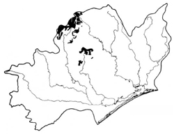
Macalister (Mr)
 | Area: 359 sq. km (1.7%) Macalister land system is mapped on Carboniferous sediments below the subalpine tract and occurs in the north-west of the East Victorian Uplands. The terrain is mountainous with ridge-and-ravine topography and long, steep slopes on which soil creep and other slope processes are active. Some structural control of slopes is evident, for example, the many subhorizontal and narrow, rocky shelves which break the steep slopes are due to beds of hard rock. The land is similar in geology and topography to Turton land system but has a much more humid climate. Very steep slopes, active soil creep and high, natural erosion rates result in soils which are extremely shallow and very stony, with much rock outcrop. Deeper soils may occur on protected or lower, gentler slopes. The vegetation is mainly shrubby open forest II or III. with closed fernland in moist, protected valley heads. | 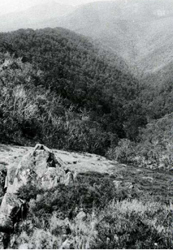 The characteristic ridge and ravine topography |
| CLIMATE Rainfall, mean (mm) Temperature, mean (°C) Seasonal growth limitations | Annual 900 - 1600; lowest January or February (50 - 90), highest August or September (120 - 180) Annual 8 - 12; lowest July (3 - 7), highest February (16 - 20) Temperature <10°C (av.): April - October Rainfall < potential evapotranspiration: January, February; occasional winter snow |
| GEOLOGY Age, lithology | Carboniferous quartzose sandstones, feldspathic sandstones and silty sandstones of the Snowy Plains Formation |
| PHYSIOGRAPHY Landscape Elevation range (m) Relative relief (m) Drainage pattern Drainage density (km/km2) | Steep mountains with ridge-and-ravine topography 380 - 1460 220 - 680 Dendritic 0.4 |
| PRESENT LAND USE | Uncleared: hardwood forestry (mainly general construction and ash timber); bush grazing of cattle; apiculture |
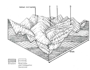 | 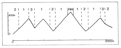 |
| LAND COMPONENT Percentage of land system Diagnostic features | 1 80 Steep slopes with humid forest | 2 10 Lower slopes and valley sides with drier forest | 3 10 Protected slopes and valleys with more vigorous humid forest |
| PHYSIOGRAPHY Slope %, typical and (range) Slope shape | 35 - 45, (10 - 100) Straight | 35 - 45, (10 - 100) Straight, some concave | 35 - 40, (5 - 50) Straight, some concave |
| SOIL | |||
| Parent material | Quartzose and feldspathic sandstone | ||
| Description | Very shallow and stony brown loam to sandy clay loam; deep profiles on inclusions of more gently sloping terrain | Similar to component 1. Colluvium with deeper very stony brown loam to sandy clay loam; little differentiation with depth | Stony brown loam to sandy clay loam becoming slightly more reddish or yellowish at depth |
| Classification | Lithosols, some Red Earth/Krasnozems Um6.21, Um5.42 | Probably Brown Earths/Lithosols - | Brown Earths, Lithosols Um7.11, Uml.43 |
| Surface texture | Loam to sandy clay loam | Loam to sandy clay loam | Loam to sandy clay loam |
| Surface consistence | Soft | Soft | Soft |
| Depth (m) | <0.4 | <0.4; >1.0 on colluvium | >1.0 |
| Nutrient status | Low | ||
| Available soil water capacity | Moderate | ||
| Perviousness to water | Rapid | ||
| Drainage | Good | ||
| Exposed stone (%) | >60 | <50 | >40 |
| Sampled profile number | - | - | - |
| NATIVE VEGETATION Structure of vegetation and characteristic species of dominant stratum (+ Predominant species) | Mainly shrubby open forest III, IV: Pure or mixed stands of E. cypellocarpa, E. dives, E. obliqua, E. radiata, E. sieberi and at higher elevations, E. pauciflora, E. rubida | Open forest I, II or woodland I: E. dives, E. mannifera or E. macrorhyncha usually dominant. Associated species include E. radiata, E. rubida, E. sieberi | Protected slopes — open forest III, IV: Higher elevations — E. delegatensis+ often with E. rubida Lower elevations — E. regnans+ often with E. obliqua Valleys — open forest III of E. viminalis+ and/or E. radiata+ or closed fernland of Dicksonia antarctica |
Disturbance | Affected process and trend | Primary resultant deterioration | Casual activities | Primary off-site process | ||
Form | Susceptibility of components | Incidence with components | ||||
— reduction in leaf area, rooting depth and/or perenniality — reduction in density of tree roots | Reduced transpiration, resulting in: a) increased deep percolation b) increased regolith wetness Decreased root-binding | Nutrient loss Soil creep Soil creep | Not determined 1,3; high 2; moderate 1,3; high 2; moderate | Not determined Uncommon Uncommon | Removal of trees Accelerated by major disturbances of native vegetation Accelerated by major disturbances of native vegetation |
Increased sediment load Increased sediment load |
| Increased overland flow and soil detachment | Sheet and rill erosion | 1,2,3; high | Uncommon | Clearing, logging, burning, overgrazing, road building and other earth-moving activities, trafficking by stock and vehicles. | Increased flash flows and sediment load. |
| Increased compaction With reduced infiltration | Structure decline Sheet and rill erosion | 1,2; low – moderate 1,2,3; high | Uncommon Uncommon | Increased trafficking, overgrazing, export of organic matter As for sheet and rill erosion above | - Increased flash flows |
| Increased soil break-up | Gully erosion | 1,2,3; high | Uncommon | As for sheet and rill erosion above | Increased sediment load. |
| Comments: - | ||||||
© State of Victoria (Agriculture Victoria) 1996 - .

This work, Victorian Resources Online, is licensed under a Creative Commons Attribution 4.0 licence. You are free to re-use the work under that licence, on the condition that you credit the State of Victoria (Agriculture Victoria) as author, indicate if changes were made and comply with the other licence terms.
The licence does not apply to ‘branding’ or some ‘images or photographs’ that may be owned by third parties. We ask you to seek prior approval to use images using the VRO feedback form. Access to higher quality images can also be provided on request.
This page was last updated on .