
Moroka (Ma)
 | Area: 25 sq. km (0.1%) This land system occurs on drainage depressions on plateaux mainly at lower elevations in the subalpine tract. Only the larger drainage depressions are mapped out; most of the remainder are included in Bennison land system. Moroka land system usually has abundant seepage emanating from gentle slopes and almost permanent water in anastomosing channel systems. Past erosional phases are represented in places by relict benches, with structural control evident from massive rock outcrop. Most areas of Moroka land system occur on Carboniferous sediments. The soils reflect major variation in drainage status. Less than half the area is moderately well drained and has yellow friable soils, with some reddish equivalents apparently related to underlying red-bed shales. In the rest of the area the swamps and seepage zones have shallow organic topsoils or peaty horizons overlying mineral substrata which are usually grey and mottled. All soils are moderately to strongly acidic. The flat to gentle slopes and the high organic matter contents in the surface reduce susceptibility to sheet erosion. Disturbances in drainage lines and destruction of vegetation on higher slopes can cause gullying of stream channels. Shrubby woodland I or II dominates on the better drained land with closed forest I, open heath or sedgeland where drainage is poorer. | 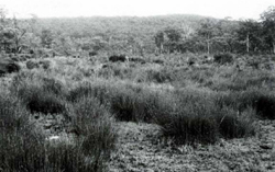 A swampy alluvial plain in the subalpine tract, edged with Eucalyptus stellulata (black sauce) and E. pauciflora (white sallee). The soil at this site contained peat to a depth of 50 cm. |
| CLIMATE Rainfall, mean (mm) Temperature, mean (°C) Seasonal growth limitations | Annual 900 - 1600; lowest January or February (50 - 90), highest August or September (120 - 180) Annual 8 - 12; lowest July (3 - 7), highest February (16 - 20) Temperature <10°C (av.): April - October Rainfall < potential evapotranspiration: February; frequent winter snow |
| GEOLOGY Age, lithology | Mainly Carboniferous sandstones, siltstones and shales; Holocene alluvium and colluvium; some rhyodacites, granites and granodiorites |
| PHYSIOGRAPHY Landscape Elevation range (m) Relative relief (m) Drainage pattern Drainage density (km/km2) | Shallow valley floors in the uplands with seepage, braided channels and relict terraces 640 - 1325 5 - 40 Braided 2.5 |
| PRESENT LAND USE | Mostly uncleared: bush grazing of cattle; apiculture (limited) |
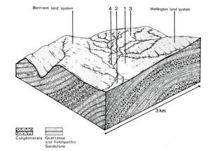 | 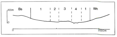 |
| LAND COMPONENT Percentage of land system Diagnostic features | 1 45 Gently sloping valley margins, extensive seepage zones | 2 35 Swampy plains with free water and peat | 3 10 Slightly elevated relict benches | 4 10 Swampy plains with channel systems; occasional better drained terraces |
| PHYSIOGRAPHY Slope %, typical and (range) Slope shape | 3 - 5, (2 - 10) Concave | 3, (0 - 6) Straight | 2, (0 - 5) Straight | <1, (0 - 2) Concave but uneven |
| SOIL | ||||
| Parent material | Sandstone, siltstone and shale; minor, rhyolite and rhyodacite; colluvium and alluvium | |||
| Description | Black loam to clay loam topsoil, often organic, grading into yellowish brown or grey (in seepage zones) clay subsoil | Probably mainly black peat topsoil over black organic clay; greyish brown mottled mineral soil below | Probably mainly dark clay loam topsoil grading into dark reddish brown or yellowish brown clay loam to clay subsoil | Mostly black peat as in component 2; along stream channels, dark greyish brown sandy loam to sandy clay loam with mottled subsoil where drainage impeded |
| Classification | Gleyed Podzolic Soils, Humic Gleys (seepage zone) Mainly Gn2. - , Gn3. - | Acid Peats O | Red and Yellow Earths Um5.52, possibly Gn- | Acid Peats, some Alluvial Soils O, small areas of Um 1.44, Uc5.21 |
| Surface texture | Loam to clay loam | - | Clay loam | Variable |
| Surface consistence | Friable when moist | Friable when moist | Friable when moist | Friable when moist |
| Depth (m) | >1.5 | >2.0 | 0.5 - 1.0 | >2.0 |
| Nutrient status | Low | Low | Low | Low |
| Available soil water capacity | Moderate to high | High | Moderate | Mostly high, some moderate |
| Perviousness to water | Moderate | Rapid | Moderate | Mostly rapid, some moderate |
| Drainage | Moderately good, in places very poor | Very poor | Moderately good to good | Mostly very poor, some good |
| Exposed stone (%) | Mostly 0 | 0 | <5 | 0 |
| Sampled profile number | - | - | - | - |
| NATIVE VEGETATION Structure of vegetation and characteristic species of Dominant stratum (+ Predominant species) | Shrubby woodland I, II: E. stellulata+ with or without E. pauciflora | Open heath: Baeckea gunniana+, Epacris spp.+ and Hakea microcarpa | Woodland I, II: E. stellulata+ with or without E. pauciflora | Closed forest I: Leptospermum grandifolium+, or Melaleuca squarrosa+: Acacia melanoxylon, Nothofagus cunninghamii and Sphagnum spp. sometimes present Woodland II: E. stellulata+ with or without E. pauciflora mostly on high terraces |
Disturbance | Affected process and trend | Primary resultant deterioration | Casual activities | Primary off-site process | ||
Form | Susceptibility of components | Incidence with components | ||||
— reduction in leaf area, rooting depth and/or perenniality |
resulting in increased deep percolation |
|
|
|
|
|
|
|
|
2,4; very low - low 3: very low |
|
|
|
|
With Reduced infiltration |
Sheet and rill erosion |
2,3; high 4; moderate 1; low 2,4; very low - low 3; very low |
Uncommon |
As for sheet and rill erosion above |
Increased flash flows |
|
|
Streambank erosion |
2; very low 3,4; moderate 4; high |
Uncommon, but locally severe |
As for sheet and rill erosion above |
Increased sediment load and turbidity |
| ||||||
© State of Victoria (Agriculture Victoria) 1996 - .

This work, Victorian Resources Online, is licensed under a Creative Commons Attribution 4.0 licence. You are free to re-use the work under that licence, on the condition that you credit the State of Victoria (Agriculture Victoria) as author, indicate if changes were made and comply with the other licence terms.
The licence does not apply to ‘branding’ or some ‘images or photographs’ that may be owned by third parties. We ask you to seek prior approval to use images using the VRO feedback form. Access to higher quality images can also be provided on request.
This page was last updated on .