
Nunniong (Ng)
 | Area: 98 sq. km (0.5%) The Older Volcanic flows were mainly valley fills but subsequent erosion has often removed the softer surrounding sediments and left the basalts as cappings on ridges. Such cappings in alpine or subalpine tracts are mapped in Nunniong land system. These areas, which have a relatively flat to gently undulating topography and rocky outcrop at breaks of slope, are usually flanked by the steep slopes and cliffs of the ridge-and-ravine terrain. Concave, treeless plains with central bogs and some small lakes are common, having formed under earlier lacustrine and paludal conditions before competent drainage developed on the lava flows. A cold climate and high rainfall have combined to produce friable, acidic soils with a high concentration of organic matter in the topsoil and with little textural change down the profile. Soils are generally shallow and basalt floaters are common. Nutrient status is presumed to be moderately high because of the basaltic parent materials. The dominant vegetation is grassy or shrubby woodland I with tussock grassland on plains of lacustrine origin. Heath and sedgeland occur in seepage areas and, along with Sphagnum, spp. in bogs. | 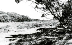 Wooded, gentle slopes adjacent to a prior lake bed |
| CLIMATE Rainfall, mean (mm) Temperature, mean (°C) Seasonal growth limitations |
Annual 900 - 1600; lowest January or February (70 - 100), highest August or September (150 - 180) Annual 4 - 8; lowest July (-2 - 0), highest February (11 - 13) Temperature <10°C (av.): April - October Rainfall < potential evapotranspiration: February; frequent winter snow |
| GEOLOGY Age, lithology |
Tertiary basalts (Older Volcanics) |
| PHYSIOGRAPHY Landscape Elevation range (m) Relative relief (m) Drainage pattern Drainage density (km/km2) |
Gently undulating plains on residual interfluve basalt cappings 1040 - 1700 40 - 160 Dendritic 0.4 |
| PRESENT LAND USE |
|
 |  |
| LAND COMPONENT Percentage of land system Diagnostic features | 1 65 Gentle slopes, rises and flat areas | 2 20 Treeless grassy lower slopes bordering depressions, often of prior lakes | 3 10 Stony hills, scarps and ravines | 4 5 Small lakes; peat bogs, often drained by small streams; seepage areas |
| PHYSIOGRAPHY Slope %, typical and (range) Slope shape | 5, (0 - 10) Various; uneven | 5, (0 - 15) Concave | 20 - 25, (10 - 40) Straight or convex | 1, (0 - 2) Straight or concave |
| SOIL | ||||
| Parent material | Basalt | |||
| Description | Black loam to clay loam merging into brown loam to clay loam; shallow | Black organic loam to clay loam merging into brown loam to clay; mostly shallow | Black loam to clay loam merging into brown loam to clay loam; shallow | Organic remains and alluvium Shallow black fibrous peat or muck overlying mineral soil or bedrock |
| Classification | Lithosols/Brown Earths/Alpine Humus Soils Um5.51, Um6.12, Um6.41, Gn4.31, Um6.21, Um6.24 | Brown Earths/Alpine Humus Soils Um6.21, Um6.12 | Humic Gleys, Acid Peats - | |
| Surface texture | Loam to clay loam | Loam to clay loam | - | |
| Surface consistence | Soft to slightly hard | Soft to slightly hard | - | |
| Depth (m) | 0.2-0.5 | 0.3-0.9 | 0- 0.4 | 1.0-2.0 |
| Nutrient status | Moderate | Moderate | Moderate | Low |
| Available soil water capacity | Moderate to high | Moderate to high | Moderate to high | High |
| Perviousness to water | Moderate to rapid | Moderate to rapid | Moderate to rapid | Moderate to rapid |
| Drainage | Moderately good to good | Moderately good to good | Good | Very poor to poor |
| Exposed stone (%) | Very variable; 1 - 75 | 0 - 15 | 30 - 80 | 0 - 15 |
| Sampled profile number | - | 6 | - | - |
| NATIVE VEGETATION Structure of vegetation and characteristic species of dominant stratum (+ Predominant species) | Grassy or shrubby woodland I, occasionally open forest I or II: E. pauciflora generally predominant, sometimes with E. stellulata or E. rubida; E. nitens occasionally predominant | Tussock grassland: Poa spp. | Tussock grassland: Poa spp. Shrubby woodland I: E. pauciflora Shrubby open forest II: E. rubida | Tussock grassland Bogs with Sphagnum sp., Epacris paludosa and/or Carex gaudichaudiana and other Cyperaceae and Juncaceae |
|
|
|
|
| ||
|
|
| ||||
— reduction in leaf area, rooting depth and/or perenniality |
resulting in: a) increased deep percolation b) decreased fog drip c) increased rate of snow melt |
Nutrient loss - - |
Not determined - - |
Not determined - - |
Removal of trees Removal of trees and understorey Removal of trees and understorey |
Increased movement of water to groundwater; increased base-flow of streams Decreased base-flow of streams Increased spring and decreased summer stream flow |
|
Increased frost heave and soil detachment |
Wind, sheet and rill erosion |
1,2,3; low |
Uncommon |
Removal of vegetative ground cover |
Increased flash flows and sediment load |
|
With Reduced infiltration |
Sheet and rill erosion |
3; moderate 1,2,3; low |
Uncommon; locally severe |
As for sheet and rill erosion above |
Increased flash flows |
|
|
Streambank erosion |
4; low – moderate 4; moderate |
Uncommon |
As for sheet and rill erosion above |
Increased sediment load |
| ||||||
© State of Victoria (Agriculture Victoria) 1996 - .

This work, Victorian Resources Online, is licensed under a Creative Commons Attribution 4.0 licence. You are free to re-use the work under that licence, on the condition that you credit the State of Victoria (Agriculture Victoria) as author, indicate if changes were made and comply with the other licence terms.
The licence does not apply to ‘branding’ or some ‘images or photographs’ that may be owned by third parties. We ask you to seek prior approval to use images using the VRO feedback form. Access to higher quality images can also be provided on request.
This page was last updated on .