
Soil/Landform Unit 181
Landform Unit Description
Page top
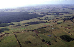 Remnant plateaux of this landform can be seen in the distance as a level plain delineating the extent of the dissection in the Heytesbury |
1.25% of CMA region Small remnants of flat ferruginised plateau near Simpson and extending toward Irrewillipe are evidence of former widespread ferruginisation. Most ferricrete hill cappings have been removed by dissection, and this set of north-north-west and south-south-east orientated ridges is the only significant remnant to the west of the Otway Range. The most common soils have gradational profiles containing ferricrete ironstone. However, some profiles possess sand veneers in the surface horizons with hardpans overlying mottled clays. Drainage of the landscape is poor, particularly where hardpans occur, and seasonal waterlogging is a problem. The ridges have been extensively cleared as part of the Heytesbury Soldier Settlement Scheme and dairy farming is the main land use. There are problems arising from low soil fertility and exposure to wind. Only one small area of native vegetation remains in the study area. | 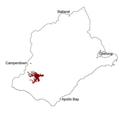 |
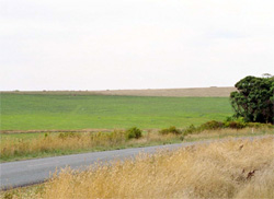 Undulating plain west of Irrewillipe |  |
 | 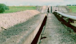 South-west gas pipeline works in 1998 |
Component | 1 | 2 | 3 |
Proportion of soil-landform unit | 65% | 25% | 10% |
| CLIMATE Rainfall (mm) | Annual: 800–950, lowest January (35), highest August (110) | ||
| Temperature (oC) | Annual: 13, lowest July (8), highest February (18) | ||
| Seasonal growth limitations | Temperature: less than l0oC (av.) June–August Precipitation: less than potential evapotranspiration late October–early April | ||
| GEOLOGY Age and lithology | |||
| Geomorphology | |||
| LANDUSE | Cleared areas: Dairy farming; some beef cattle grazing Minor cleared areas: Hardwood forestry production | ||
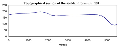
| TOPOGRAPHY Landscape | Very gently undulating plateau with north-west and south-east dissection | ||
| Elevation range (m) | 150–170 | ||
| Local relief (m) | 10 | ||
| Drainage pattern | Parallel | ||
| Drainage density (km/km2) | 1.0 | ||
| Landform | Plateaux | ||
| Landform element | Plain and very gentle slopes and crests | Gentle slopes | Lower slope and depression |
| Slope and range (%) | 2 (0–14) | 1 (0–3) | 5 (0–9) |
| Slope shape | Straight (some convex) | Straight | Concave |
| NATIVE VEGETATION Structure | Open forest | Closed scrub | Open forest |
| Dominant species | E. obliqua, E. baxteri | Leptospermum juniperinum, Melaleuca squarrosa, E. nitida, Casuarina littoralis | E. baxteri, E. ovata |
| SOIL Parent material | Weathering ferruginised remnants | Ferruginised remnants covered by varying depths of sand | Alluvial sand and clay |
| Description (Corangamite Soil Group) | Grey sand soils (16) and mottled brown, grey, yellow and red texture contrast soils with ironstone (13) | Grey sand soils, structured clay underlay (16) | Yellow-brown gradational soils, coarse structure (34) |
| Soil type sites | |||
| Surface texture | Sandy loam | Sandy loam | Sandy loam |
| Permeability | Moderate | Low | Low |
| Depth (m) | 1.7 | >2 | >2 |
| LAND CHARACTERISTICS, POTENTIAL AND LIMITATIONS | Low inherent fertility and phosphorus fixation lead to nutrient decline. Leaching of salts leads to increased salinity of drainage waters. | Low inherent fertility and leaching of permeable surface horizons lead to nutrient decline. Low permeabilities lead to seasonal waterlogging and soil compaction. | Low permeabilities and high seasonal watertables lead to seasonal waterlogging and soil compaction. Leaching of salts from landscape leads to increased salinity of drainage waters. |
© State of Victoria (Agriculture Victoria) 1996 - .

This work, Victorian Resources Online, is licensed under a Creative Commons Attribution 4.0 licence. You are free to re-use the work under that licence, on the condition that you credit the State of Victoria (Agriculture Victoria) as author, indicate if changes were made and comply with the other licence terms.
The licence does not apply to ‘branding’ or some ‘images or photographs’ that may be owned by third parties. We ask you to seek prior approval to use images using the VRO feedback form. Access to higher quality images can also be provided on request.
This page was last updated on .