
Soil/Landform Unit 48
Landform Unit Description
Page top
 Soils on lower slopes are vulnerable to waterlogging, soil salting and nutrient decline. The presence of Eucalyptus ovata is indicative of poorly drained soils |
0.09% of CMA region The undulating rises of Quaternary volcanics north of Ballan is located on the eastern boundary of the Corangamite catchment. Over 85% of the land is cleared for private use. The main vegetation class is the Herbrich Foothill Forest. Eucalyptus ovata is prevalent over much of the area due to the poorly drained manner of most soils. The weathered basalt has reasonable inherent fertility levels and a moderate water holding capacity. In the past the forest has provided sawn timber, posts and firewood; softwood plantations are now prominent in the area. Soils include acidic and neutral mottled texture contrast soils. There are minor occurrences of shallow alkaline brown cracking clays. Waterlogging is common throughout the landscape, and these areas tend to have strongly sodic subsoils. As a result, soil salting is often expressed at the surface. | 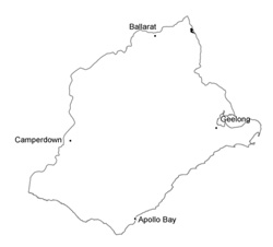 |
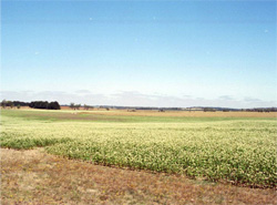 Pastures grown for hay (including clover shown here) is an infrequent land use | 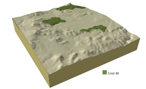 |
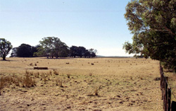
| 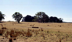 Gentle slopes are prone to waterlogging and pugging from cattle |
| Component | 1 | 2 | 3 | 4 | 5 | 6 |
| Proportion of soil-landform unit | 55% | 1% | 1% | 3% | 30% | 10% |
| CLIMATE Rainfall (mm) | Annual: 860 | |||||
| Temperature (oC) | Minimum 7, Maximum 17 | |||||
| Precipitation less than potential evapotranspiration | November-March | |||||
| GEOLOGY Age and lithology | Quaternary basalt, Ordovician marine shale and sandstone, Neogene fluvio-marine sand | |||||
| Geomorphology | ||||||
| LANDUSE | Uncleared: Water supply; nature conservation Cleared: Sheep and cattle grazing cropping (cereal and pasture); softwood plantations | |||||
| TOPOGRAPHY Landscape | Undulating rises | |||||
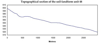
| Elevation range (m) | 500-611 | |||||
| Local relief (m) | 2 | |||||
| Drainage pattern | Dendritic | |||||
| Drainage density (km/km2) | 1.9 | |||||
| Landform | Slightly dissected undulating plain | Rolling plain and rises | Drainage depression and terrace | |||
| Landform element | Long gentle upper slopes | Depression | Stony rise | Crest | Long gentle slope | |
| Slope and range (%) | 2 (1-3) | 1 (1-2) | 3 (2-5) | 1 (1-3) | 5 (3-9) | 1 (1-2) |
| Slope shape | Straight | Straight | Convex | Convex | Straight | Straight |
| NATIVE VEGETATION Structure | - | - | - | Woodland | Open forest | Woodland |
| Dominant species | E. ovata, E. viminalis, E. rubida, E. obliqua | E. ovata, E. viminalis, E. rubida, E. obliqua | E. ovata, E. viminalis, E. rubida, E. obliqua | E. obliqua, E. radiata | E. obliqua, E. viminalis | E. viminalis, E. radiata |
| SOIL Parent material | In situ weathered basalt | Alluvium | In situ weathered basalt | In situ weathered sandstone and shale | In situ wathered sandstone and shale | Unconsolidated gravel, sand, silt and clay |
| Description (Corangamite Soil Group) | Black clay soil, uniform texture, coarse structure (31) | Red shallow, stony gradational soil (40) | Shallow stony red gradational soil (25) | Red mottled brown, grey or yellow texture contrast soil (25) | Dark brown soil - variable (34) | |
| Soil type sites | ||||||
| Surface texture | Clay loam | Clay | Clay loam | Gravelly loam | Loamy clay | Fine sandy clay loam |
| Permeability | Moderate to low | Moderate | High | High | Moderate to low | Moderate to low |
| Depth (m) | 1.5 | 1.5 | 0.5 | 0.6 | 1 | 2 |
| LAND CHARACTERISTICS, POTENTIAL AND LIMITATIONS | Low to moderate water holding capacity. Upper soil susceptible to sheet and rill erosion with increasing slope. Waterlogging is common with strongy sodic subsoils. Soil are hardsetting and mottled. | Clay soils beside creeks are prone to waterlogging. Streambank undercutting and streambank erosion can occur with excessive rains and inadequate ground coverage. | Overland flow is likely to cause sheet and rill erosion. Nutrient decline is possible due to shallow and permeable soils. | Moderate slopes and hardsetting surfaces result in significant overland flow. Sheet and rill erosion also occur from this overland flow. Soil salting and discharge is an issue. Soil compaction is also a limitation for soils with shallow topsoils. | Moderate slopes and hardsetting surfaces result in significan overland flow. Sheet and rill erosion also occur from this overland flow. Soil salting and discharge is an issue. Soil compaction is also a limitation for soils with shallow topsoils. | Low-lying areas receiving drainage experience waterlogging. Overland flow is likely to cause sheet and rill, streambank and gully erosion. |
© State of Victoria (Agriculture Victoria) 1996 - .

This work, Victorian Resources Online, is licensed under a Creative Commons Attribution 4.0 licence. You are free to re-use the work under that licence, on the condition that you credit the State of Victoria (Agriculture Victoria) as author, indicate if changes were made and comply with the other licence terms.
The licence does not apply to ‘branding’ or some ‘images or photographs’ that may be owned by third parties. We ask you to seek prior approval to use images using the VRO feedback form. Access to higher quality images can also be provided on request.
This page was last updated on .