
Soil/Landform Unit 33
Landform Unit Description
Page top
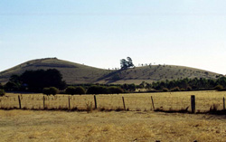 Steep low cones of Black Hill |
0.03% of CMA region The steep low cones in the Gordon-Millbrook area (Hopwoods, Black and O’Donnell Hill) are derived from Pleistocene basalt, scoria and tuff. These low cones are some of the many eruption points of the Western Uplands that includes many scoria and lava cones to the north. Slopes of these low cones can be quite steep and therefore can be limited in land use. Vegetation communities includes Scoria Cone Woodland, Plains Grassy Woodland and Herb-rich Foothill Forest, most of which is located on O’Donnell Hill. Soils consist of friable red gradational soils that are shallow on the crests and upper slopes then become deeper and darker red on mid and lower slopes. With an average annual rainfall of 900 mm, land use is only limited by excessive slopes and possible waterlogging in excessively wet seasons. Compaction of these red gradational soils, especially with high traffic conditions (e.g. horticulture), can be managed with controlled traffic and supplementation of soil organic matter. |  |
 Land unse includes grazing (mainly for fat lamb production) and horticulture |  |
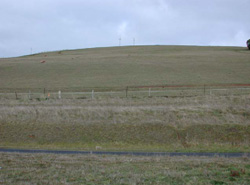
|  South western slope of Black Hill |
Component | 1 | 2 | 3 | 4 |
Proportion of soil-landform unit | 50% | 17% | 17% | 16% |
| CLIMATE Rainfall (mm) | Annual: 890 | |||
| Temperature (oC) | Minimum 6, Maximum 16 | |||
| Precipitation less than potential evapotranspiration | November-March | |||
| GEOLOGY Age and lithology | Pleistocene basalt, scoria, tuff | |||
| Geomorphology | ||||
| LANDUSE | Uncleared: Nature conservation Cleared: Cropping; sheep and cattle grazing; horticulture (including potatoes); residential development | |||
| TOPOGRAPHY Landscape | Steep low cones | |||
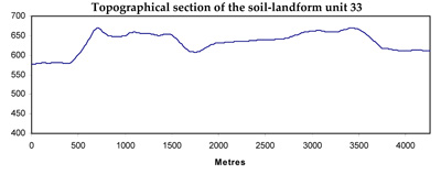
| Elevation range (m) | 550-692 | |||
| Local relief (m) | 60 | |||
| Drainage pattern | - | |||
| Drainage density (km/km2) | <0.1 | |||
| Landform | Volcanic cone | Undulating plain | ||
| Landform element | Slope and crest | Crest and upper slope | Mid slope | Unconsolidated sediments |
| Slope and range (%) | 20 (5-40) | 4 (1-6) | 3 (2-7) | 1 (1-2) |
| Slope shape | Straight | Convex | Straight | Concave |
| NATIVE VEGETATION Ecological Vegetation Class | Scoria Cone Woodland (2.4%), Plains Grassy Woodland (2.3%), Herb-rich Foothill Forest (1.6%) | |||
| Dominant species | E. viminalis, E. radiata, E. obliqua | |||
| SOIL Parent material | In situ weathered basalt and scaoria | In situ weathered basalt and scoria | In situ weathered basalt and scoria | In situ weathered sandstone and shale |
| Description (Corangamite Soil Group) | Red gradational soil, fine structure (40) | Dark red gradational soil, fine structure (40) | ||
| Soil type sites | ||||
| Surface texture | Clay loam | Clay loam | Loam | Clay loam |
| Permeability | High | High | High | Low |
| Depth (m) | 1 | 2 | 1.5 | 1.5 |
| LAND CHARACTERISTICS, POTENTIAL AND LIMITATIONS | Steep slopes combined with overland flow cause rill and sheet erosion. Leaching is associated with nutrient decline. | Steep slopes combined with overland flow cause rill and sheet erosion. Leaching is associated with nutrient decline. | Steep slopes combined with overland flow cause rill and sheet erosion. Leaching is associated with nutrient decline. Soil compaction will benefit from addition of organic matter. | Soils tend to have a low permeability with hardsetting surfaces. Waterlogging and compaction also occur. |
© State of Victoria (Agriculture Victoria) 1996 - .

This work, Victorian Resources Online, is licensed under a Creative Commons Attribution 4.0 licence. You are free to re-use the work under that licence, on the condition that you credit the State of Victoria (Agriculture Victoria) as author, indicate if changes were made and comply with the other licence terms.
The licence does not apply to ‘branding’ or some ‘images or photographs’ that may be owned by third parties. We ask you to seek prior approval to use images using the VRO feedback form. Access to higher quality images can also be provided on request.
This page was last updated on .