
Soil/Landform Unit 196
Landform Unit Description
Page top
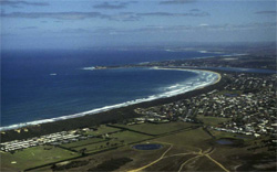 Coastal town of Barwon Downs has experienced a marked population and residential development increase over the last 10 years. The residential development is the primary land use for this unit |
0.07% of CMA region The undulating plains around Barwon Heads provide the most eastern landscape of the Western Plains. The plains fringe the wetlands and river system of the Moolap Sunklands and the Barwon River. The area is derived from a variety of sedimentary sources including sandy calcarenites and coastal dunes. Relief is relatively subdued and reflects the aeolian nature of this part of the Bellarine Peninsula. With much of the land cleared for residential or grazing purposes, the land is particularly vulnerable to wind erosion. Soils of the landscape include sandy yellow and/or red texture contrast soils that tend to have alkaline pH trends. Soils are prone to high permeabilities in upper sands with restricted flow paths in the subsoil. The nutrient and water holding capacity is low in surface horizons, with sodic subsoils common. Vegetation classes of these coastal plains includes Calcarenite Dune Woodland and Coastal Dune Scrub Mosaic. |  |
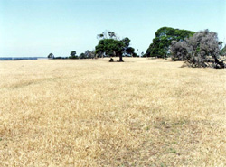 The other major land use if for sheep and cattle grazing on cleared land | 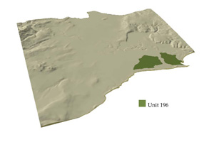 |
 | 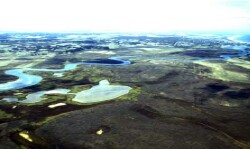 Wetlands of the Moolap Sunklands and the Barwon River winding its way towards Barwon Downs |
Component | 1 | 2 | 3 |
Proportion of soil-landform unit | 20% | 30% | 50% |
| CLIMATE Rainfall (mm) | Annual: 580 | ||
| Temperature (oC) | Minimum 10, Maximum 19 | ||
| Precipitation less than potential evapotranspiration | October–April | ||
| GEOLOGY Age and lithology | Quaternary, Pleistocene; Dune limestone, calcareous quartz sandstone (aeolianite) with interbedded soil layers | ||
| Geomorphology | |||
| LANDUSE | Uncleared areas: Nature conservation including wetlands and coastal dunes Cleared areas: Residential development; sheep and beef cattle grazing | ||
| TOPOGRAPHY Landscape | Undulating plains | ||
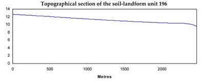
| Elevation range (m) | 6–13 | ||
| Local relief (m) | 5 | ||
| Drainage pattern | Deranged | ||
| Drainage density (km/km2) | 0.8 | ||
| Landform | Low rises | Plains | |
| Landform element | Broad low crest | Low mid slopes | |
| Slope and range (%) | 2 (1–4) | 3 (2–6) | 0 (0–1) |
| Slope shape | Convex | Convex | Straight |
| NATIVE VEGETATION Ecological Vegetation Class | Calcarenite Dune Woodland (6.7%); Coastal Dune Scrub Mosaic (0.4%) | ||
| SOIL Parent material | |||
| Description (Corangamite Soil Group) | Calcarenite, sand, silt and clay | Calcarenite, sand, silt and clay | Sand, silt, clay and Calcarenite |
| Soil type sites | |||
| Surface texture | Loamy sand | Loamy sand | Loamy sand |
| Permeability | High to moderate | Moderate | Moderate to low |
| Depth (m) | <2 | < 2 | <2 |
| LAND CHARACTERISTICS, POTENTIAL AND LIMITATIONS | Texture contrast soils with deep surface and subsurface horizons or deep sands. High permeability in upper soils, restricted in subsoil. Nutirent holding capacity and water holding capacity low in upper soil, but often calcareous particularly subsoil, though generally sodic. | Texture contrast soils with deep surface and subsurface horizons or deep sands. High permeability in upper soils, restricted in subsoil. Nutrient holding capacity and water holding capacity low in upper soil, but often calcareous particularly subsoil, though generally strongly sodic and possibly saline. | Texture contrast soils with deep surface and subsurface horizons or deep sands. High permeability in upper soils, restricted in subsoil. Nutrient holding capacity and water holding capacity low in upper soil, but often calcareous particularly subsoil, though generally strongly sodic and probably saline. |
© State of Victoria (Agriculture Victoria) 1996 - .

This work, Victorian Resources Online, is licensed under a Creative Commons Attribution 4.0 licence. You are free to re-use the work under that licence, on the condition that you credit the State of Victoria (Agriculture Victoria) as author, indicate if changes were made and comply with the other licence terms.
The licence does not apply to ‘branding’ or some ‘images or photographs’ that may be owned by third parties. We ask you to seek prior approval to use images using the VRO feedback form. Access to higher quality images can also be provided on request.
This page was last updated on .