
Soil/Landform Unit 19
Landform Unit Description
Page top
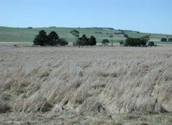
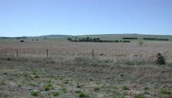
 Undulating low granitic hills south of Pittong. A blue gum plantation is evident on the lower colluvial slopes on these hills |
0.30% of CMA region The undulating to gently undulating low granitic hills south of Pittong are part of the granitic landscapes within the Midlands of the Western Uplands. This Devonian granite unit is located south of Pittong in the north of the catchment. The gentle to undulating slopes graduate into the prominent footslopes, drainage depressions and alluvial fans of Unit 18. Remnant vegetation on the granite is sparse with the Grassy Woodland, Heathy Dry Forest and Riparian Woodland among the major classes. The soils consist of an association of mottled texture contrast soils and deep brown sands. Areas of rocky outcrop occur on the upper slopes and crests with deep sands. Minor mottled sodic texture contrast soils occur on the mid to lower slopes. Unbleached mottled texture contrast soils with lighter textured surfaces may also occur on some of the lower crests. Land use is restricted to grazing and cropping due to the low available water holding capacity and ready leaching of nutrients from these soils. Gully erosion occurs to a moderate extent and is difficult to control on the steeper slopes and valleys of these hills. Salting is also expressed at the surface as evidenced by the presence of spiny rush. | 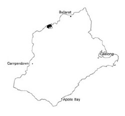 |
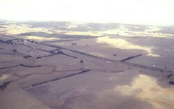
 Undulating hillslopes south of Pittong | 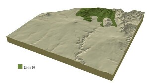 |
|  Looking north-east towards the Late Devonian granite |
Component | 1 | 2 | 3 |
Proportion of soil-landform unit | 15% | 30% | 55% |
| CLIMATE Rainfall (mm) | Annual: 680 | ||
| Temperature (oC) | Minimum 7, Maximum 18 | ||
| Precipitation less than potential evapotranspiration | November-March | ||
| GEOLOGY Age and lithology | Devonian granite | ||
| Geomorphology | |||
| LANDUSE | Uncleared: Nature conservation Cleared: Sheep grazing; limited cropping (cereal) | ||
| TOPOGRAPHY Landscape | Undulating slopes of the low granite hills | ||
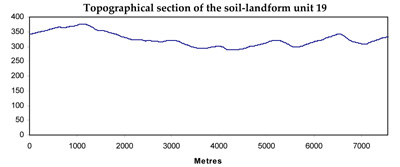
| Elevation range (m) | 266-392 | ||
| Local relief (m) | 60-100 | ||
| Drainage pattern | Dendritic | ||
| Drainage density (km/km2) | 2.0 | ||
| Landform | Hill slopes | ||
| Landform element | Low crests | Upper and mid slopes | Lower slopes |
| Slope and range (%) | 2 (1-5) | 5 (3-10) | 2 (1-5) |
| Slope shape | Convex | Convex | Concave |
| NATIVE VEGETATION Ecological Vegetation Class | Grassy Woodland (0.3%) | ||
| SOIL Parent material | Granite | Granite | Granite |
| Description (Corangamite Soil Group) | Mottled brown, grey or yellow texture contrast soils with light textured surfaces (3) | Acidic mottled brown, grey or yellow texture contrast soils (3) | Sodic mottled brown, grey or yellow texture contrast soils (2) |
| Soil type sites | |||
| Surface texture | Coarse sandy clay loam | Coarse sandy clay loam | Sandy clay loam |
| Permeability | Moderate | High | Very low |
| Depth (m) | <1.5 | >2 | >2 |
| LAND CHARACTERISTICS, POTENTIAL AND LIMITATIONS | Uniform sands with prominent texture contrast, very low nutrient holding capacity and water holding capacity in sandy coils, high in underlying clays. Susceptibility to deep seepage, nutrient decline and sheet erosion. | Moderate slopes, low permeability and hardsetting surfaces result in overland flow. Subsurface flow (deep sandy surface soil) and deep seepage combine in leaching of salts, rilly and gully erosion, as well as sheet erosion. | Moderate slopes, low permeability and harsetting surfaces result in overland flow. Subsurface flow (deep sandy surface soil) and deep seepage combine in leaching of salts, rill and gully erosion, as well as sheet erosion. |
© State of Victoria (Agriculture Victoria) 1996 - .

This work, Victorian Resources Online, is licensed under a Creative Commons Attribution 4.0 licence. You are free to re-use the work under that licence, on the condition that you credit the State of Victoria (Agriculture Victoria) as author, indicate if changes were made and comply with the other licence terms.
The licence does not apply to ‘branding’ or some ‘images or photographs’ that may be owned by third parties. We ask you to seek prior approval to use images using the VRO feedback form. Access to higher quality images can also be provided on request.
This page was last updated on .