
Soil/Landform Unit 18
Landform Unit Description
Page top
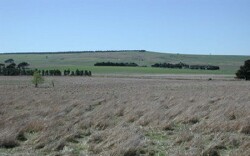 The colluvial footslopes often provide deep sands or texture contrast soils that have higher water holding capacities than the steeper slopes with shallow soils of the neighbouring granite hills |
0.08% of CMA region The alluvial fan deposits and footslopes of this unit received most of their source material from the granitic hillslopes higher in the catchment. Neighbouring Unit 15/19 (Devonian granite) this unit is located south of Pittong in the north of the catchment within the Midlands of the Western Uplands. The footslopes and deposits are characterised by areas of gentle slopes graduating into prominent drainage depressions and drainage lines. The alluvial/colluvial source granitic material is characterised by deep mottled yellow/brown/grey duplex soils graduating into heavier clays in the minor drainage lines. Remnant vegetation includes only 0.1% Grassy Woodland with extensive clearing of the land. Land use is restricted to grazing and cropping due to the low available water holding capacity and ready leaching of nutrients from these soils. Gully erosion occurs to a minor extent and is easier to control than the steeper slopes and valleys of the granite hills due to the gently undulating nature of the slopes. | 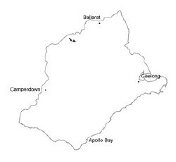 |
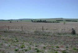 Long colluvial slopes and alluvial fans of these granite hills often have salinity expressed at the break-of-slopes | 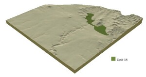 |
| 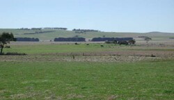 Fan deposits that are derived mainly from the granitic colluvial slopes |
Component | 1 | 2 |
Proportion of soil-landform unit | 80% | 20% |
| CLIMATE Rainfall (mm) | Annual: 680 | |
| Temperature (oC) | Minimum 7, Maximum 18 | |
| Precipitation less than potential evapotranspiration | October-March | |
| GEOLOGY Age and lithology | Recent clay, sand and gravel and Devonian granite | |
| Geomorphology | ||
| LANDUSE | Uncleared: Nature conservation Cleared: Sheep grazing; limited cropping (cereal) | |
| TOPOGRAPHY Landscape | Colluvial footslopes and fans from granite hills | |
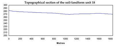
| Elevation range (m) | 260-299 | |
| Local relief (m) | 10 | |
| Drainage pattern | Dendritic | |
| Drainage density (km/km2) | 1.1 | |
| Landform | Footslopes | Colluvial fans |
| Landform element | Long gentle slops | Fans |
| Slope and range (%) | 4 (1-7) | 3 (1-6) |
| Slope shape | Irregular | Concave |
| NATIVE VEGETATION Ecological Vegetation Class | Grassy Woodland (01%) | |
| SOIL Parent material | Granitic, colluvium; sand, clay and silt, in situ granite | Granitic colluvium; sand, clay and silt |
| Description (Corangamite Soil Group) | Mottled brown, yellow or grey texture contrast soils (1) | Mottled brown, yellow or grey texture contrast soils (1) |
| Soil type sites | ||
| Surface texture | Loamy sand | Loamy sand |
| Permeability | Slowly | Slowly |
| Depth (m) | >2 | >2 |
| LAND CHARACTERISTICS, POTENTIAL AND LIMITATIONS | Large texture contrast between topsoil and subsoil, low water holding capacity and low to moderate nutrient holding capacity of subsurface and surface soils, higher in subsoil. Coarse sand component throughout profile. Hardsetting surface soil with some stone. Sodic soil, generally strongly. Deep soil. Very low permeability in heavy clay subsoil, high in upper soil. Moderately rapid site drainage. Variable susceptibility to sheet, rill, gully and tunnel erosion. | Large texture contrast between topsoil and subsoil, low water holding capacity and low to moderate nutrient holding capacity of subsurface and surface soils, higher in subsoil. Coarse sand component throughout profile. Hardsetting surface soil with some stone. Sodic soil, generally strongly. Deep to very deep soil. Very low permeability in heavy clay subsoil, high in upper soil. Moderate rapid site drainage. Variable susceptibility to sheet, rill, gully and tunnel erosion. |
© State of Victoria (Agriculture Victoria) 1996 - .

This work, Victorian Resources Online, is licensed under a Creative Commons Attribution 4.0 licence. You are free to re-use the work under that licence, on the condition that you credit the State of Victoria (Agriculture Victoria) as author, indicate if changes were made and comply with the other licence terms.
The licence does not apply to ‘branding’ or some ‘images or photographs’ that may be owned by third parties. We ask you to seek prior approval to use images using the VRO feedback form. Access to higher quality images can also be provided on request.
This page was last updated on .