
Soil/Landform Unit 178
Landform Unit Description
Page top
 The lower plain at the base of the You Yangs has a suite of geological sediments |
0.06% of CMA region Gently undulating plains on Neogene and Quaternary sediments occur near Anakie East in the east of the Corangamite catchment. Here much of the land has been cleared or highly disturbed, with very little remnant vegetation (less than 1.1% Plains Grassy Woodland). The sedimentary sands, silt and clay have a low inherent fertility and low water holding capacity. The forest in the past has provided sawn timber, posts and firewood, and softwood plantations are likely to fill the void created by protection of these remaining vegetation stands. Soils include alkaline mottled texture contrast soils with structured or massive subsoils. These relatively shallow stony soils are prone to sheet erosion, while the deeper soils in the drainage depression suffer from gully erosion and soil salting. |  |
 Undulating plain of fluvial sediments | 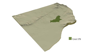 |
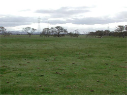
 | 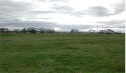 Grazing is a common land use on this unit |
Component | 1 | 2 | 3 |
Proportion of soil-landform unit | 40% | 57% | 3% |
| CLIMATE Rainfall (mm) | Annual: 490 | ||
| Temperature (oC) | Minimum 9, Maximum 20 | ||
| Precipitation less than potential evapotranspiration | September–April | ||
| GEOLOGY Age and lithology | Quaternary fluvial clay, sand and gravel and basalt, Neogene fluvio-marine sand | ||
| Geomorphology | |||
| LANDUSE | Uncleared: Nature conservation Cleared: Sheep and beef cattle grazing; cropping (cereal); softwood plantation | ||
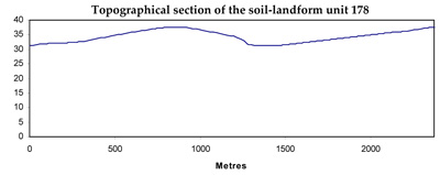
| TOPOGRAPHY Landscape | Gently undulating plain | ||
| Elevation range (m) | 21–63 | ||
| Local relief (m) | 8 | ||
| Drainage pattern | Dendritic | ||
| Drainage density (km/km2) | 1.6 | ||
| Landform | Long gentle slopes | Plains | Drainage lines |
| Landform element | Slopes | Plains | Depression |
| Slope and range (%) | 2 (1–4) | 1 (0–3) | 1 (1–2) |
| Slope shape | Convex | Straight | Straight |
| NATIVE VEGETATION Ecological Vegetation Class | Plains Grassy Woodland (1.1%) | ||
| SOIL Parent material | Sand, silt and clay | Sand, silt and clay | Sand, silt and clay |
| Description (Corangamite Soil Group) | Alkaline mottled brown, grey or yellow texture contrast soils (14) | Alkaline mottled brown, grey or yellow texture contrast soils (14) | Alkaline mottled brown, grey or yellow texture contrast soils (32) |
| Soil type sites | |||
| Surface texture | Fine sandy loam | Fine sandy loam | Fine sandy loam |
| Permeability | Low to moderate | Low | Very low |
| Depth (m) | <2 | >2 | >2 |
| LAND CHARACTERISTICS, POTENTIAL AND LIMITATIONS | Texture contrast. Low water holding capacity and nutrient holding capacity in upper soil, higher in subsoil. Upper soil susceptible to sheet and rill erosion with increasing slope. Strongly sodic, coarse structure or massive. Hardsetting and mottled. Moderate site drainage. | Texture contrast. Low water holding capacity and nutrient holding capacity in upper soil, higher in subsoil. Upper soil susceptible to sheet and rill erosion with increasing slope. Strongly sodic, coarse structure or massive. Hardsetting and mottled. Slow site drainage. | Texture contrast. Low water holding capacity and nutrient holding capacity in upper soil, higher in subsoil. Upper soil susceptible to sheet and rill erosion with increasing slope. Strongly sodic, coarse structure or massive. Hardsetting and mottled. Very slow site drainage. |
© State of Victoria (Agriculture Victoria) 1996 - .

This work, Victorian Resources Online, is licensed under a Creative Commons Attribution 4.0 licence. You are free to re-use the work under that licence, on the condition that you credit the State of Victoria (Agriculture Victoria) as author, indicate if changes were made and comply with the other licence terms.
The licence does not apply to ‘branding’ or some ‘images or photographs’ that may be owned by third parties. We ask you to seek prior approval to use images using the VRO feedback form. Access to higher quality images can also be provided on request.
This page was last updated on .