
Soil/Landform Unit 157
Landform Unit Description
Page top
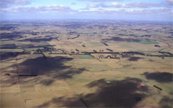 The undulating rises south-east of Cobden provide deep soils with high rainfall that support a variety of land uses |
0.09% of CMA region This grouping of very small dissected remnant cappings occurs within the Western Plains of the Corangamite region. Located south of Cobden and east of Jancourt, the gently undulating rises are derived from Neogene non-calcareous sediments (sands) over Neogene limestone and marl. The surrounding streams and tributraries of the Curdies River are relatively steep and prone to some mass movement. The unit is comprised of broad low crests, gently undulating slopes and plains, with only limited remnant native vegetation (less than 1% Plains Grassy Woodland). Soils of these landform elements include alkaline and neutral (sodic) mottled brown, grey and yellow texture contrast soils (Kurosols/Chromosols). Susceptibility to waterlogging occurs in the depressions but site drainage is moderately rapid elsewhere on the plains and crests. Given the higher rainfall of the area, the susceptibility to nutrient decline is moderate to high, particularly where surface soils are light. Slight susceptibility to sheet erosion occurs on the slopes. Land use is mainly intensive grazing (dairying) with some associated cropping. |  |
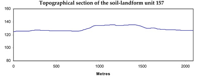
 Undulating rise cappings of sedimentary and volcanic geological source |  |
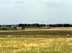
 | 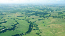 Residual cappings of the undulating rises near Cobden are mainly used for dairying |
Component | 1 | 2 | 3 |
Proportion of soil-landform unit | 25% | 60% | 15% |
| CLIMATE Rainfall (mm) | Annual: 790 | ||
| Temperature (oC) | Minimum 9, Maximum 19 | ||
| Precipitation less than potential evapotranspiration | October-March | ||
| GEOLOGY Age and lithology | |||
| Geomorphology | |||
| LANDUSE | Uncleared areas: Hardwood forestry for sawlogs, posts and poles; softwood plantations; water supply; nature conservation Cleared areas: Dairy farming; sheep and beef cattle grazing; softwood plantations; water supply | ||
| TOPOGRAPHY Landscape | Gently undulating plains | ||
| Elevation range (m) | 67-165 | ||
| Local relief (m) | 15 | ||
| Drainage pattern | Parallel | ||
| Drainage density (km/km2) | 0.6 | ||
| Landform | Rises | Undulating plains | |
| Landform element | Broad low crest | Slopes | Plain |
| Slope and range (%) | 2 (1-4) | 4 (3-10) | 1 (0-3) |
| Slope shape | Convex | Convex | Straight |
| NATIVE VEGETATION Ecological Vegetation Class | Plains Grassy Woodland (0.8%) | ||
| SOIL Parent material | Clay, silt, sand and marl | Clay, silt, sand and marl | Clay, silt and sand |
| Description (Corangamite Soil Group) | Alkaline, neutral and acidic, brown, grey or yellow mottled texture contrast soils (23) | Alkaline, neutral and acidic, brown, grey or yellow mottled texture contrast soils (23) | |
| Soil type sites | |||
| Surface texture | Clay loam, fine sandy loam | Clay loam | Fine sandy loam |
| Permeability | Moderate | Moderate to low | Low |
| Depth (m) | <2 | <2 | <2 |
| LAND CHARACTERISTICS, POTENTIAL AND LIMITATIONS | Large or moderate texture contrast with low to moderate nutrient holding capacity and water holding capacity in subsurface and surface soil, higher in subsoil. Heavy, possibly expansive clay subsoil. Moderately rapid site drainage. | Moderate texture contrast with low to moderate nutrient holding capacity and water holding capacity in subsurface and surface soil, higher in subsoil. Heavy, possibly expansive clay subsoil. Moderately rapid site drainage. | Large texture contrast with low nutrient holding capacity and water holding capacity in subsurface and surface soil, higher in subsoil. Heavy, possibly expansive clay subsoil. Slow site drainage, higher susceptibility to waterlogging and compaction. |
© State of Victoria (Agriculture Victoria) 1996 - .

This work, Victorian Resources Online, is licensed under a Creative Commons Attribution 4.0 licence. You are free to re-use the work under that licence, on the condition that you credit the State of Victoria (Agriculture Victoria) as author, indicate if changes were made and comply with the other licence terms.
The licence does not apply to ‘branding’ or some ‘images or photographs’ that may be owned by third parties. We ask you to seek prior approval to use images using the VRO feedback form. Access to higher quality images can also be provided on request.
This page was last updated on .