
Soil/Landform Unit 186
Landform Unit Description
Page top
 |
0.06% of CMA region The near-level to gently undulating sedimentary plains south of Anakie on the Western Plains are derived from long gentle slopes with minor depressions and occasional stony rises. Geology is quite diverse including Quaternary basalt, Recent clay, sand and gravel, and minor Devonian granite. However the greatest geological source for soils of these plains is the Neogene fluvio-marine sediments. The western margin of this unit abuts a large alluvial floor at the base of an erosional steep slope or scarps that lead to an elevated plateau of volcanic and sedimentary origin. Soils of these plains are alkaline red texture contrast, with heavier clay soils found in the minor drainage depressions. Hardsetting surfaces of these soils are prone to sheet erosion from the lack of infiltration. Nearly all land has been cleared with very few remnants observed in the landscape. Rainfall generally exceeds evaporation between the months of April and October where the land use is sheep and cattle grazing. |  |
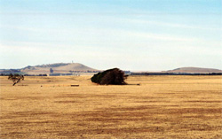
 Long gentle slopes looking towards the You Yangs | 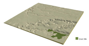 |
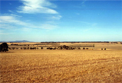
 | 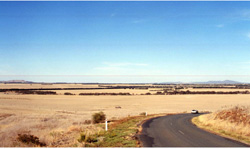 Looking south-east over the plains from Pringles Road. A large alluvial depression at the base of an erosional scarp provides the western boundary of this unit |
Component | 1 | 2 | 3 |
Proportion of soil-landform unit | 95% | 3% | 2% |
| CLIMATE Rainfall (mm) | Annual: 560 | ||
| Temperature (oC) | Minimum 9, Maximum 19 | ||
| Precipitation less than potential evapotranspiration | October–April | ||
| GEOLOGY Age and lithology | Quaternary basalt, Neogene fluvio-marine sediments, Recent clay, sand and gravel and minor Devonian granite | ||
| Geomorphology | |||
| LANDUSE | Uncleared: Nature conservation Cleared: Sheep and cattle grazing, occasional cropping (cereal) | ||
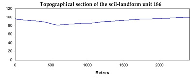
| TOPOGRAPHY Landscape | Near level plains | ||
| Elevation range (m) | 54–115 | ||
| Local relief (m) | 2 | ||
| Drainage pattern | Dendritic | ||
| Drainage density (km/km2) | 2.1 | ||
| Landform | Depressions | ||
| Landform element | Long gentle slopes | Depression | Stony rise |
| Slope and range (%) | 1 (1–3) | 1 (1–2) | 3 (2–5) |
| Slope shape | Straight | Straight | Convex |
| NATIVE VEGETATION Ecological Vegetation Class | Plains Grassy Woodland (0.7%) | ||
| Dominant species | E. ovata, E viminalis, E. rubida, E. obliqua | E. ovata, E viminalis, E. rubida, E. obliqua | E. ovata, E viminalis, E. rubida, E. obliqua |
| SOIL Parent material | Unconsolidated sediments with In situ weathered basalt | In situ weathered rock | |
| Description (Corangamite Soil Group) | Black clay soil, coarse structure (39) | Red shallow, stony gradational soil (40) | |
| Soil type sites | SW103, SW98, SFS4 | ||
| Surface texture | Clay loam | Clay | Clay loam |
| Permeability | Moderate-low | Moderate | High |
| Depth (m) | 1.5 | 1.5 | 0.5 |
| LAND CHARACTERISTICS, POTENTIAL AND LIMITATIONS | Hardsetting surfaces allow little infiltration, therefore high surface runoff. Slowly permeable subsoils are also quite sodic and prone to erosion if surface horizons are removed through sheet erosion. Periodic waterlogging common in wet seasons. Compaction of surfaces can benefit from addition of organic matter. | Clay soils beside creeks. Periodic waterlogging common in wet seasons. Streambank undercutting and stream bank erosion common. Slowly permeable subsoils are also quite sodic and prone to gully erosion. Compaction of surfaces can benefit from addition of organic matter. | Overland flow prominent due to shallow soil depth. Leaching of nutrients (nutrient decline) also a limitation of these rises along with sheet erosion. Compaction of surfaces can benefit from addition of organic matter. |
© State of Victoria (Agriculture Victoria) 1996 - .

This work, Victorian Resources Online, is licensed under a Creative Commons Attribution 4.0 licence. You are free to re-use the work under that licence, on the condition that you credit the State of Victoria (Agriculture Victoria) as author, indicate if changes were made and comply with the other licence terms.
The licence does not apply to ‘branding’ or some ‘images or photographs’ that may be owned by third parties. We ask you to seek prior approval to use images using the VRO feedback form. Access to higher quality images can also be provided on request.
This page was last updated on .