
WP5
Location: Longeranong
Australian Soil Classification: Episodic-Epicalcareous, Epipedal, Red VERTOSOL
Northcote Factual Key: Ug 5.3
Great Soil Group: grey, brown and red clays
Local Soil Type Name: Longeranong Clay
General Landscape Description: Western edge of River Frontage Landscape Unit (also adjacent to Prior Stream Floodplain Landscape)
Site Description: Low rise on edge of a gently undulating plain.
Geology: Quaternary alluvial and aeolian deposits (Woorinen Formation).
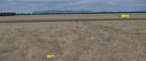 WP5 Landscape |
Soil Profile Morphology:
Surface Soil
| A1 | 0-10 cm | Dark red (2.5YR4/6); light medium clay; surface cracking evident; strong coarse blocky, parting to strong polyhedral structure; very firm consistence dry; some evidence of platy compaction; pH 7.4; clear change to: | 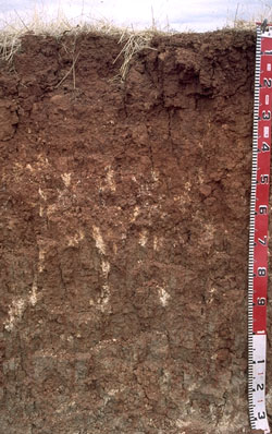 WP5 Profile |
| Subsoil | |||
| B21 | 10-25 cm | Dark red (2.5YR4/8); heavy clay; strong coarse blocky, parting to moderate medium blocky structure; strong consistence dry; pH 8.1; gradual change to: | |
| B22k | 25-45 cm | Dark red (2.5YR4/6) with a few reddish yellow (5YR6/8) mottles; medium clay; strong coarse blocky, parting to moderate medium blocky structure; strong consistence dry; contains a few (5%) carbonate/silica nodules (5-10 mm in size) as well as soft carbonate; slightly calcareous; pH 9.1; gradual change to: | |
| B23k | 45-60 cm | Red (2.5YR5/6) and reddish yellow (5YR6/8); medium clay; strong coarse blocky, parting to moderate medium blocky structure; strong consistence dry; contains a few (5-10 %) soft and semi hard carbonate segregations; slightly calcareous; pH 8.2; gradual change to: | |
| B24 | 60-105 cm | Light grey (2.5Y7/2) with yellowish red (5YR5/8) mottles; heavy clay; strong coarse prismatic,parting to moderate coarse to medium blocky structure; strong consistence dry; contains a few (2-5 %) soft and semi hard carbonates, as well as manganese flecks; slightly calcareous; pH 8.7; gradual change to: | |
| B25 | 105-130 cm | Light grey (2.5Y7/2) with yellowish red (5YR5/8) mottles; heavy clay; slickensides, strong coarse prismatic, parting to strong blocky structure; strong consistence dry; contains a few (2-5 %) soft and semi-hard carbonates as well as manganese flecks; slightly calcareous; pH 8.8. |
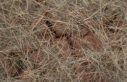
WP5 Surface cracking.
Key Profile Features:
- High clay content throughout soil profile.
- The soil cracks significantly when dry.
- Vertic properties (ie. slickensides present) in deep subsoil.
| - | pH | Salinity | ||
Surface (A1 horizon) | Slightly Alkaline | Very Low | Sodic | None 1 |
Subsoil (B21 horizon) | Moderately Alkaline | Very Low | Sodic | Slight 1 |
Deeper Subsoil (at 1 metre) | Strongly Alkaline | Extremely High | Strongly Sodic | None 2 |
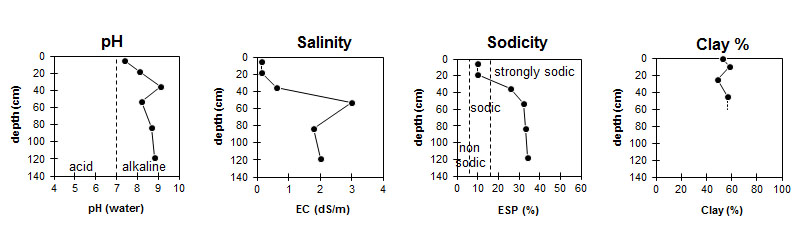
| The surface is slightly alkaline. The subsoil is moderately alkaline, becoming strongly alkaline at 80 cm. | The salinity rating is very low in the upper profile and becomes extremely high at 50 cm depth. | The surface is sodic. The subsoil becomes strongly sodic at 25 cm. |
|
Chemical and Physical Analysis:
Horizon | Horizon Depth (cm) | pH (water) | pH (CaCl2) | EC dS/m | Exchangeable Cations | |||
Ca | Mg | K | Na | |||||
meq/100g | ||||||||
A1 | 0-10 | 7.4 | 6.3 | 0.13 | 8.4 | 8.6 | 1.8 | 1.9 |
B21 | 10-25 | 8.1 | 6.8 | 0.13 | 8.8 | 10 | 1.9 | 2.3 |
B22 | 25-45 | 9.1 | 8.3 | 0.63 | 7.4 | 12 | 1.4 | 7.2 |
B23 | 45-60 | 8.2 | 8.1 | 3.0 | 10 | 14 | 1.6 | 12 |
B24 | 60-105 | 8.7 | 8.3 | 1.8 | 7.7 | 15 | 1.7 | 12 |
B25 | 105-130 | 8.8 | 8.4 | 2.0 | 7.9 | 16 | 1.8 | 13 |
Horizon | Horizon Depth (cm) | Oxidisable Organic Carbon % | Total Nitrogen % | Sodium Chloride % | Wilting Point pF4.2 | Coarse Sand (0.2-2.0 mm) | Fine Sand (0.02-0.2 mm) | Silt (0.002-0.02 mm) | Clay (<0.002 mm) |
A1 | 0-10 | 1.1 | 0.12 | 19.6 | 13 | 20 | 7 | 52 | |
B21 | 10-25 | 23.4 | 11 | 17 | 8 | 58 | |||
B22 | 25-45 | 0.05 | 23 | 12 | 24 | 10 | 48 | ||
B23 | 45-60 | 0.12 | 25.1 | 9 | 18 | 8 | 57 | ||
B24 | 60-105 | 0.17 | 25.7 | ||||||
B25 | 105-130 | 0.24 |
Management Considerations:
Whole Profile
- Plant available water capacity (PAWC) is considered to be low (estimated at 75 mm). This is based on available laboratory data and assumes an effective rooting depth of 45 cm. The effective rooting depth will be restricted in the strongly sodic deeper subsoil which also has a high salinity rating.
Surface (A) Horizon
- The surface soil is sodic and disperses completely after remoulding. This indicates that structural degradation (eg. surface sealing, increased cloddiness) may occur if the soil is cultivated or overstocked in a moist to wet condition. Also, raindrop action on bare surface soil may also promote dispersion and result in surface sealing or surface crust formation. Surface cover should be maintained to protect against raindrop damage. The use of gypsum may assist in ameliorating the surface soil.
- When the soil is dry, heavy rains will move down soil cracks. This rapid recharge can be valuable for the survival of plants near wilting. When wet, the soil will swell and further infiltration of water will be relatively slow.
- Tillage of cracking clay soils should be avoided when the soil is wetter than the plastic limit. At such a moisture condition, excessive tillage, trafficking or overstocking may result in soil structural damage (eg. compaction, smearing) occurring. Ideally, tillage and trafficking should take place when the soil is drier than the plastic limit, down to at least the tillage depth. [See Appendix A for details on clay compaction (page A-20) and plastic limit (page A-31)]. There is some evidence of soil compaction at this site with some platy structure development in the A1 horizon.
Subsoil (B) Horizons
- The coarsely structured upper subsoil is sodic and disperses slightly. This is likely to restrict root and water movement somewhat. The relatively high level of exchangeable magnesium relative to calcium in the upper subsoil is also likely to have a detrimental effect on soil structure.
- Strong dispersion occurs in the upper subsoil after remoulding. This indicates that disturbance to this horizon during tillage when the soil is wet will result in structural degradation occurring. If tillage is to take place then the soil should be drier than the plastic limit to at least the depth of tillage.
- The level of soluble salts becomes extremely high in the deeper subsoil (from 50 cm depth). At these levels, the growth of salt sensitive species (eg. faba beans, linseed, chick peas, lupins) may be restricted. The level of soluble salts becomes high at 60 cm depth.
- The subsoil is mainly strongly alkaline. This indicates that some nutrients (eg. iron, manganese, zinc and copper) may be poorly available to plants and that deficiencies may occur. Deficiencies can be determined by plant tissue analysis. Boron toxicity can also occur in strongly alkaline soils.
- The major part of the subsoil is not likely to shrink and swell as significantly as for the grey clay sites. Slickensides are evident only in the deep subsoil (ie. greater than 1 metre depth).
© State of Victoria (Agriculture Victoria) 1996 - 2025.

This work, Victorian Resources Online, is licensed under a Creative Commons Attribution 4.0 licence. You are free to re-use the work under that licence, on the condition that you credit the State of Victoria (Agriculture Victoria) as author, indicate if changes were made and comply with the other licence terms.
The licence does not apply to ‘branding’ or some ‘images or photographs’ that may be owned by third parties. We ask you to seek prior approval to use images using the VRO feedback form. Access to higher quality images can also be provided on request.
This page was last updated on 25/01/2019.