
WLRA141
|
| WLRA141 | 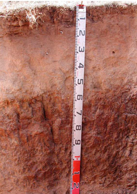 Eutrophic, Mottled-Subnatric, Brown SODOSOL | |
|
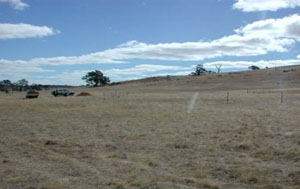
Location | Shays Flat-Malakoff Road, Landsborough, western Victoria | |||
|
Landform | Rolling low hills | |||
|
Geology | Palaeozoic (Cambrian) Warrak Formation: marine sandstone, siltstone, schist | |||
|
Element | Footslope | |||
|
Slope | 5% | |||
|
Aspect | North | |||
Horizon | Depth (cm) | Description | ||
A1 | 0–15 | Brown (7.5YR4/4); sandy clay loam; weak coarse subangular blocky; rough ped-fabric; weak dry consistence; very few small subrounded quartz gravels; many very fine and fine roots; water repellent; pH 5.1; clear and wavy boundary to: | ||
A21 | 15–30 | Brown (7.5YR4/4), conspicuously bleached light brown (7.5YR6/4); loamy sand; massive (structureless) very weak dry consistence; few small subrounded quartz gravels; common very fine and fine roots; pH 4.9; gradual and smooth boundary to: | ||
A22 | 30–55 | Light yellowish brown (10YR6/4), conspicuously bleached very pale brown (10YR8/4); sandy clay loam; massive (structureless) weak dry consistence; few small subrounded quartz gravels; few medium ferromanganiferous nodules; few very fine and fine roots; pH 6.6; sharp and smooth boundary to: | ||
B21 | 55–90 | Brown (10YR4/3) with many medium distinct dark reddish brown (2.5YR3/4) mottles; medium heavy clay; strong coarse to very coarse prismatic, parting to strong coarse to medium angular blocky structure; rough and smooth ped-fabric; very firm moderately moist consistence; very few medium manganiferous nodules; few prominent clay skins; few very fine and fine roots; pH 7.4; gradual and smooth boundary to: | ||
B22 | 90–125+ | Dark yellowish brown (10YR4/4) with common medium faint reddish brown and many medium dark red (2.5YR3/6) mottles; light clay; massive (structureless); strong moderately moist consistence; very few medium manganiferous nodules; no roots; pH 7.8. | ||
| Management Considerations | ||||
| ||||
Horizon | Depth (cm) | pH (water) | pH (CaCl2) | EC dS/m | Exch. Al mg/kg | Exchangeable Cations cmol-/kg | Field Capacity (pF2.5) | Wilting Point (pF4.2) | Coarse Sand % | Fine Sand % | Silt % | Clay % | |||
Ca | Mg | K | Na | ||||||||||||
A1 | 0–15 | 5.1 | 4.5 | 0.06 | 22 | 1.2 | 0.43 | 0.41 | 0.05 | 18.1 | 5.3 | 7.4 | 68.2 | 7 | 14 |
A21 | 15–30 | 4.9 | 4.4 | <0.05 | 31 | 0.81 | 0.26 | 0.17 | <0.05 | 16.3 | 3.7 | 8.7 | 71.4 | 8.5 | 8 |
A22 | 30–55 | 6.6 | 5.9 | <0.05 | |||||||||||
B21 | 55–90 | 7.4 | 6.4 | 0.07 | 7.1 | 5.7 | 0.9 | 1.1 | 33.8 | 19.6 | 1.4 | 28.4 | 14 | 51.5 | |
B22 | 90–125+ | 7.8 | 6.8 | 0.08 | 4.4 | 4.9 | 0.55 | 0.87 | 26.9 | 13 | 3.5 | 44.1 | 8.5 | 40.5 | |
© State of Victoria (Agriculture Victoria) 1996 - .

This work, Victorian Resources Online, is licensed under a Creative Commons Attribution 4.0 licence. You are free to re-use the work under that licence, on the condition that you credit the State of Victoria (Agriculture Victoria) as author, indicate if changes were made and comply with the other licence terms.
The licence does not apply to ‘branding’ or some ‘images or photographs’ that may be owned by third parties. We ask you to seek prior approval to use images using the VRO feedback form. Access to higher quality images can also be provided on request.
This page was last updated on .