
WLRA138
|
| WLRA138 | 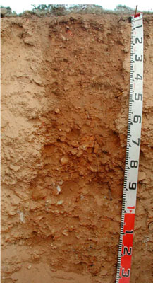 Acidic, Eutrophic, Red KANDOSOL | |
|
Location | Shays Flat-Malakoff Road, Landsborough, western Victoria | |||
|
Landform | Rolling rises | |||
|
Geology | White Hills Gravel: residual fluvial gravel and sand deposits | |||
|
Element | Hillslope | |||
|
Slope | 12% | |||
|
Aspect | North-north-west | |||
Horizon | Depth (cm) | Description | ||
A0 | 0–2 | Very dark greyish brown (10YR3/2); silty loam; massive (structureless); common subangular fine to medium quartz gravels; many very fine and fine roots; water repellent; field pH 6.0; abrupt and smooth boundary to: | ||
A1 | 2–50 | Strong brown (7.5YR5/6); sandy loam; massive (structureless); very weak dry consistence; abundant medium to coarse quartz gravels; common fine and very fine roots; pH 5.1; gradual and smooth boundary to: | ||
B2 | 50–90 | Yellowish red (5YR5/8); sandy clay loam; very weak dry consistence; abundant fine quartz gravels to quartz stones; few fine and very fine roots; pH 5.2; gradual and smooth boundary to: | ||
C | 90–135+ | Massive (structureless); strongly cemented quartz gravels and stones. | ||
| Management Considerations | ||||
| ||||
Horizon | Depth (cm) | pH (water) | pH (CaCl2) | EC dS/m | Exch. Al mg/kg | Exchangeable Cations cmol-/kg | Field Capacity (pF2.5) | Wilting Point (pF4.2) | Coarse Sand % | Fine Sand % | Silt % | Clay % | |||
Ca | Mg | K | Na | ||||||||||||
A1 | 2–50 | 5.1 | 4.7 | 0.05 | 17 | 1 | 0.23 | 0.1 | <0.05 | 11 | 2.4 | 41.8 | 41.1 | 8.3 | 3.8 |
B2 | 50–90 | 5.2 | 4.5 | <0.05 | 35 | 1.2 | 0.81 | 0.14 | <0.05 | 10.9 | 5 | 46.8 | 28.8 | 8.5 | 13.5 |
© State of Victoria (Agriculture Victoria) 1996 - .

This work, Victorian Resources Online, is licensed under a Creative Commons Attribution 4.0 licence. You are free to re-use the work under that licence, on the condition that you credit the State of Victoria (Agriculture Victoria) as author, indicate if changes were made and comply with the other licence terms.
The licence does not apply to ‘branding’ or some ‘images or photographs’ that may be owned by third parties. We ask you to seek prior approval to use images using the VRO feedback form. Access to higher quality images can also be provided on request.
This page was last updated on .