WCFA9
Location: Litchfield
Australian Soil Classification: Hypercalcic, Effervescent, Yellow SODOSOL
Northcote Factual Key: Dy2.13
General Landscape Description: Flat Plain.
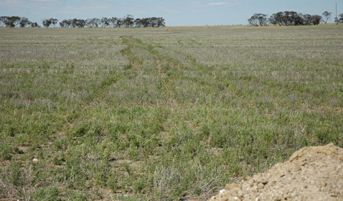
Site Description: Drainage depression with linear gilgai. Cultivated cropping paddock.
Geology: Parra – Woorinen Formation

WCFA9 Landscape
Soil Profile Morphology:
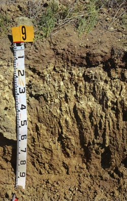
| Surface Soil |  WCFA9 profile | ||
| A1 | 0-10 cm | Dark greyish brown (10YR4/2); fine sandy clay loam; loose self-mulching surface condition; weak medium blocky, parting to weak fine blocky structure; firm consistence dry; contains very few fine manganiferous nodules and very few fine and medium calcareous nodules; moderately calcareous; pH 8.1; sharp and smooth change to: | |
| Subsoil | |||
| B21k | 10-40 cm | Light yellowish brown (2.5Y6/4); medium clay; strong coarse sub-angular blocky, parting to strong fine sub-angular blocky structure; strong consistence dry; contains very few fine manganiferous nodules and many coarse calcareous nodules and soft segregations; moderately calcareous; pH 8.8; clear and irregular change to: | |
| B22k | 40-55 cm | Pale yellow (2.5Y7/4); heavy clay; strong prismatic, parting to moderate angular blocky structure; strong to very strong consistence dry; contains many coarse calcareous nodules and soft segregations and very few fine manganiferous nodules; moderately calcareous; pH 9.1; clear and smooth change to: | |
| B23 | 55-100+ cm | Light yellowish brown (2.5Y6/4); medium heavy clay; moderate medium prismatic, parting to moderate medium angular blocky structure; very firm to strong consistence dry; fine calcareous nodules and soft segregations common, with very few fine manganiferous nodules; moderately calcareous; pH 9.2. | |
Soil Profile Characteristics:
pH | Salinity Rating | |||
Surface (A1 horizon) | Moderately Alkaline | Low | Non-Sodic | None |
Subsoil (B21 horizon) | Strongly Alkaline | Medium | Sodic | None1 |
Deeper Subsoil (at 55-100 cm) | Very Strongly Alkaline | High | Strongly Sodic | Slight |

| The salinity rating in the surface soil is low. The upper subsoil has a medium salinity rating becoming high at depth.
| The surface is non-sodic. The upper subsoil is sodic and the deeper subsoil is strongly sodic. | Boron content increases with depth becoming high in the deeper subsoil. |
|
Chemical and Physical Analysis:
Horizon | Horizon Depth (cm) | pH (water) | pH (CaCl2) | EC dS/m | NaCl % | Exchangeable Cations | |||
Ca | Mg | K | Na | ||||||
meq/100g | |||||||||
A1 | 0-10 | 8.1 | 7.7 | 0.18 | - | 30 | 4.9 | 2.6 | 0.52 |
B21k | 10-40 | 8.8 | 8.2 | 0.52 | 0.05 | 14 | 12 | 1.2 | 4.4 |
B22k | 40-55 | 9.1 | 8.5 | 0.93 | 0.11 | 6.9 | 17 | 1.4 | 8.2 |
B23K | 55-100+ | 9.2 | 8.7 | 1.3 | 0.16 | 4.7 | 20 | 1.8 | 13 |
Horizon | Horizon Depth (cm) | Oxidisable Organic Carbon % | Total Nitrogen % | Available Boron mg/kg | Field Capacity pF2.5 | Wilting Point pF4.2 | Coarse Sand (0.2-2.0 mm) | Fine Sand (0.02-0.2 mm) | Silt (0.002-0.02 mm) | Clay (<0.002 mm) |
A1 | 0-10 | 1.1 | 0.11 | 2.3 | 34.4 | 17 | 18 | 22 | 24 | 26 |
B21k | 10-40 | 7 | 36.9 | 25.2 | 7 | 12 | 7 | 50 | ||
B22k | 40-55 | 20 | 43.5 | 25.9 | ||||||
B23K | 55-100+ | 36 | 49.6 | 28.5 |
Profile Described By: Nathan Robinson, Grant Boyle and John Martin (October 2006).


