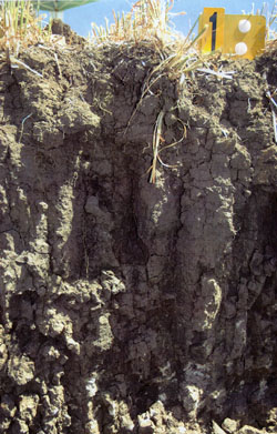
WCFA1
Location: Lower Norton
Australian Soil Classification: Endocalcareous-Endohypersodic, Epipedal, Grey VERTOSOL
Soil Map Unit: Similar to Murtoa Clay.
General Landscape Description: Rise within a ridge spur. Wind erosion evident.
Site Description: Mid to upper hill slope.
Land Use: Cropping paddock.
Geology: Parilla Sand.

WCFA1 Landscape
Soil Profile Morphology:
| Surface Soil |  WCFA1 profile | ||
| A1 | 0-15 cm | Very dark greyish brown (10YR3/2); light clay; loose surface condition; weak fine sub-angular blocky structure; strong consistence dry; rough fabric; contains very few fine gravely sub-angular quartz fragments; pH 7.6; gradual and smooth change to: | |
| Subsoil | |||
| B21 | 15-40 cm | Very dark grey (10YR3/1); light clay; strong coarse prismatic, parting to strong medium angular blocky structure; smooth fabric; strong consistence dry; contains very few soft calcareous segregations; few distinct slickensides evident; pH 8.3; gradual and smooth change to: | |
| B22 | 40-60 cm | Dark grey (2.5Y4/1); medium clay; strong coarse prismatic, parting to strong medium angular blocky structure; smooth fabric; very strong consistence dry; contains very few soft calcareous segregations; many distinct slickensides evident; pH 8.7; clear and irregular change to: | |
| B23k | 60-80+ cm | Medium heavy clay; strong coarse to medium angular blocky structure; smooth fabric; very strong consistence dry; soft calcareous segregations common; many distinct slickensides evident; pH 8.9. | |
Soil Profile Characteristics:
pH | Salinity Rating | |||
Surface (A1 horizon) | Slightly Alkaline | Low | Non-Sodic | None |
Subsoil (B21 horizon) | Moderately Alkaline | Low | Sodic | None |
Deeper Subsoil (at 60-80 cm) | Moderately Alkaline | Low-Medium | Strongly Sodic | None1 |

| The salinity rating is low to medium throughout the whole profile.
| The surface is non-sodic. The upper subsoil is sodic and the deeper subsoil becomes strongly sodic. | The boron content increases with depth. |
|
Horizon | Horizon Depth (cm) | pH (water) | pH (CaCl2) | EC dS/m | NaCl % | Exchangeable Cations | |||
Ca | Mg | K | Na | ||||||
meq/100g | |||||||||
A1 | 0-15 | 7.6 | 7.3 | 0.24 | - | 27 | 4.7 | 1.4 | 0.45 |
B21 | 15-40 | 8.3 | 7.8 | 0.29 | <0.02 | 23 | 9.4 | 0.57 | 2.1 |
B22 | 40-60 | 8.7 | 8.1 | 0.41 | <0.02 | 21 | 14 | 0.55 | 4.1 |
B3k | 60-80 | 8.9 | 8.3 | 0.51 | <0.02 | 18 | 16 | 0.63 | 6.3 |
Horizon | Horizon Depth (cm) | Oxidisable Organic Carbon % | Total Nitrogen % | Available Boron mg/kg | Field Capacity pF2.5 | Wilting Point pF4.2 | Coarse Sand (0.2-2.0 mm) | Fine Sand (0.02-0.2 mm) | Silt (0.002-0.02 mm) | Clay (<0.002 mm) |
A1 | 0-15 | 1.7 | 0.16 | 2 | 34.4 | 21.1 | 12 | 34 | 12 | 35 |
B21 | 15-40 | 2 | 31.6 | 19.2 | 11 | 39 | 9 | 37 | ||
B22 | 40-60 | 5.1 | 38.3 | 21.5 | 11 | 33 | 9 | 43 | ||
B3k | 60-80 | 11 | 40.9 | 23.4 |
Profile Described By: Nathan Robinson, Grant Boyle and John Martin (October 2006).


