
LS10
|
| LS10 | 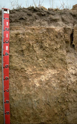 Calcic, Mottled-Mesonatric, Yellow Sodosol (sandy) | |
|
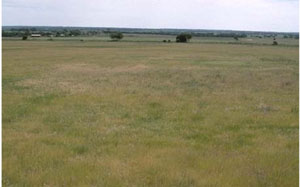
Location | Propodollah Ridge, western Victoria | |||
|
Landform | Ridge | |||
|
Geology | Pliocene Parilla Sand: marine sand and silt | |||
|
Element | Hillslope (middle) | |||
|
Slope | 3% | |||
|
Aspect | North-east | |||
Horizon | Depth (cm) | Description | ||
A1 | 0–10 | Brown (10YR4/3) loamy sand; weakly structured; weak consistence (dry); contains very few (2%) ferromanganiferous nodules; pH 6.3; sharp and wavy boundary to: | ||
A2 | 10–15 | Discontinuous light yellowish brown (10YR6/4) conspicuously bleached sand; single grained (structureless); loose consistence (dry). | ||
B11 | 15–18 | Yellowish red (5YR5/6) and (10YR6/4) mottles; sandy loam (clayey); single grained (structureless), very firm consistence (moist); pH 7.7. | ||
B12 | 18–30 | Yellowish brown (10YR5/4) with (7.5YR5/8) mottles; light sandy clay loam; single grained (structureless), strong consistence (moist); pH 8.1. | ||
B21 | 30–55 | Pale yellow (2.5YR7/4) light clay (sandy); moderate coarse blocky structure; very strong consistence (moist); pH 8.8. | ||
B22 | 55–70 | Light brown (7.5YR6/4) medium clay (sandy); contains a common (10–20%) amount of soft calcareous segregations; pH 9.5. | ||
B23 | 70–90 | Brownish yellow (10YR6/5) with yellowish red mottles; light medium clay (sandy); contains a common (10–20%) amount of ferruginous nodules; pH 9.2. | ||
B24 | 90–110 | Similar to above with more mottling | ||
C | 110+ | Weathered sandstone. | ||
| Management considerations | ||||
| ||||
Site LS10 | Sample depth cm | pH | EC dS/m | NaCl % | Ex Ca cmol-/kg | Ex Mg cmol-/kg | Ex K cmol-/kg | Ex Na cmol-/kg | Ex Al mg/kg | Ex acidity cmol-/kg | FC -30okPa | PWP -1500okPa | KS % | FS % | Z % | C % | |
Horizon | H2O | CaCl2 | |||||||||||||||
A1 | 0–10 | 6.3 | 5.8 | 0.28 | NA | 3.1 | 0.1 | 0.1 | <0.1 | NA | NA | 6.6 | 1.9 | NA | NA | NA | NA |
A2 | 10–15 | NA | NA | NA | NA | NA | NA | NA | NA | NA | NA | NA | NA | NA | NA | NA | NA |
B11 | 15–18 | 7.7 | 6.7 | 0.16 | NA | 2.6 | 2.5 | 0.1 | 1.1 | NA | NA | 10.7 | 4.2 | 56 | 28 | 3 | 12 |
B12 | 18–30 | 8.1 | 6.8 | 0.14 | NA | 2.5 | 3.7 | 0.2 | 1.8 | NA | NA | 13.8 | 5 | 42 | 40 | 2 | 15 |
B21 | 30–55 | 8.8 | 7.9 | 0.38 | <0.05 | 4.2 | 9.3 | 0.4 | 5.6 | NA | NA | NA | NA | 33 | 25 | 3 | 36 |
B22 | 55–70 | 9.5 | 8.7 | 1.09 | 0.17 | 5 | 6.5 | 0.5 | 7.8 | NA | NA | NA | NA | NA | NA | NA | NA |
B23 | 70–90 | 9.2 | 8.5 | 1.08 | 0.19 | 3.2 | 6.6 | 0.5 | 7.4 | NA | NA | NA | NA | 38 | 33 | 2 | 26 |
B24 | 90–110 | 8.2 | 7.5 | 1.2 | 0.24 | 3 | 6.7 | 0.5 | 7.4 | NA | NA | NA | NA | NA | NA | NA | NA |
© State of Victoria (Agriculture Victoria) 1996 - 2025.

This work, Victorian Resources Online, is licensed under a Creative Commons Attribution 4.0 licence. You are free to re-use the work under that licence, on the condition that you credit the State of Victoria (Agriculture Victoria) as author, indicate if changes were made and comply with the other licence terms.
The licence does not apply to ‘branding’ or some ‘images or photographs’ that may be owned by third parties. We ask you to seek prior approval to use images using the VRO feedback form. Access to higher quality images can also be provided on request.
This page was last updated on 25/01/2019.